Serbian Majority Areas Map in Serbo-Croatian States Before WW1

Alex Cartwright
Senior Cartographer & GIS Specialist
Alex Cartwright is a renowned cartographer and geographic information systems specialist with over 15 years of experience in spatial analysis and data...
Geographic Analysis
What This Map Shows
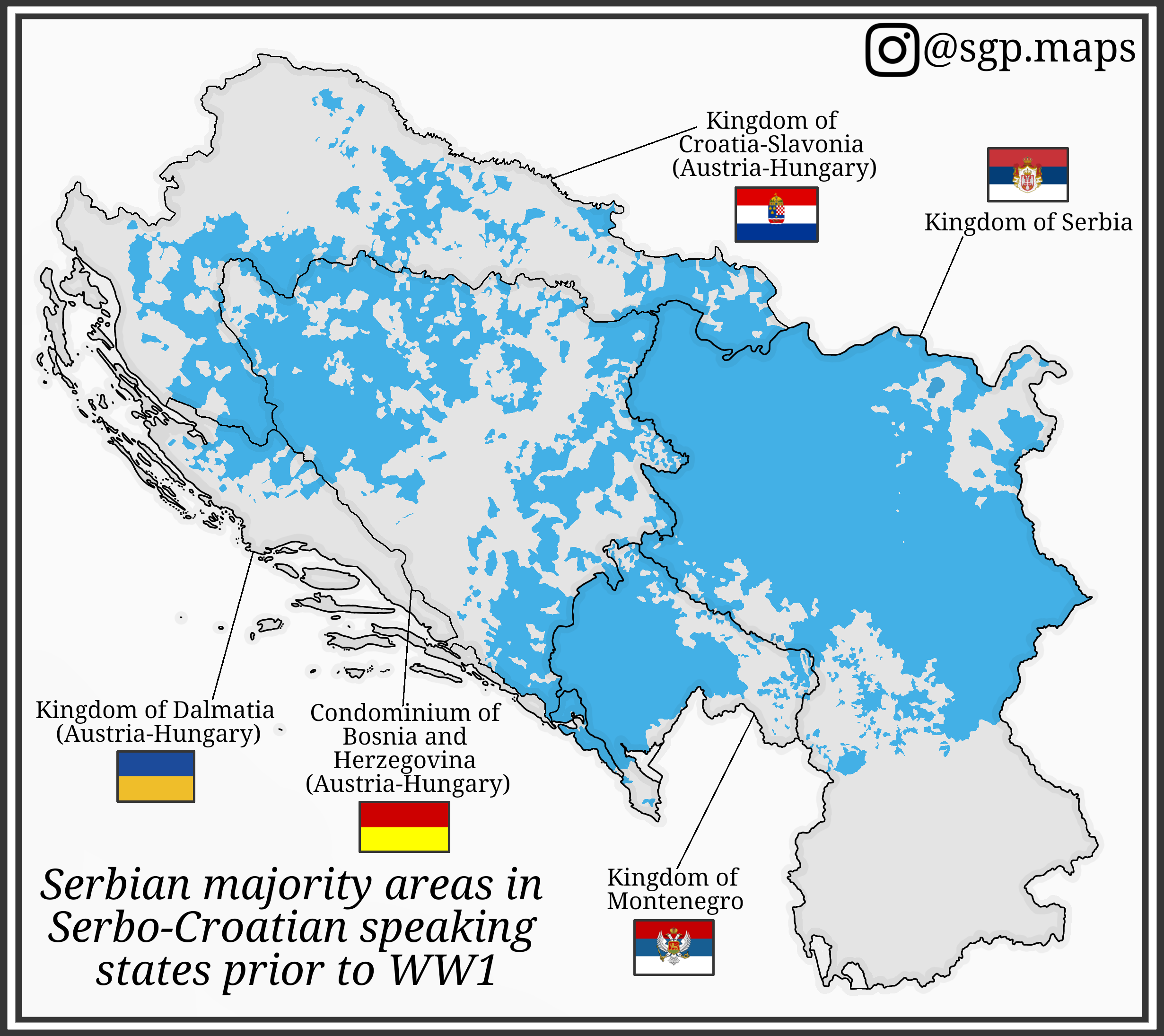
This map illustrates the distribution of Serbian majority areas in the regions where Serbo-Croatian was spoken prior to World War I. It highlights the demographic landscape of the Balkans during a time of significant political and social change, showcasing the concentration of Serbian populations in various territories, particularly within the Austro-Hungarian Empire and the Kingdom of Serbia. By mapping these areas, we can better understand the ethnic and cultural dynamics that influenced the region's history leading up to the war.
Deep Dive into Serbian Demographics
The demographic patterns of the Serbo-Croatian-speaking regions were shaped by a complex interplay of historical migration, political boundaries, and cultural identity. Historically, the Serbian population has been significant in regions that are now part of modern-day Serbia, Bosnia and Herzegovina, Montenegro, and Croatia. In the late 19th and early 20th centuries, these areas were marked by a burgeoning sense of nationalism, which often revolved around ethnic identity and the quest for autonomy.
Interestingly, the Serbian population was not evenly distributed across these territories. For example, in Bosnia and Herzegovina, Serbs were a notable majority in certain areas, particularly in the eastern regions. According to the 1910 census, Serbs constituted roughly 40% of the population in Bosnia and Herzegovina, with significant concentrations in places like East Sarajevo and Banja Luka.
In Croatia, particularly in regions like Slavonia, Serbs also formed a substantial part of the population, often in rural areas, while urban centers like Zagreb had a more diverse demographic. The presence of Serbian communities in these territories can be traced back centuries, illustrating a long-standing connection between the Serbian people and their lands.
Moreover, the emergence of nationalism during this period was not just a Serbian phenomenon; it was part of a broader trend affecting various ethnic groups in the Balkans. This created a patchwork of identities and loyalties that complicated the political landscape. The desire for a Greater Serbia was driven by the belief that all Serbs should live in one nation, which further intensified ethnic tensions.
Regional Analysis
When we analyze the map further, we can see distinct patterns in the distribution of Serbian populations across different regions. In Vojvodina, for instance, the Serbian majority is evident, particularly around cities like Novi Sad and Subotica. This area was part of the Austro-Hungarian Empire, which allowed for a unique blend of cultures, yet it also fostered a strong sense of Serbian identity among its inhabitants.
In contrast, the regions of Dalmatia and Slavonia present a more mixed demographic. Here, Serbs coexisted with Croats and other ethnic groups, leading to both cultural exchanges and tensions. The presence of Serbs in mixed communities often resulted in competition for political power and resources, especially as nationalistic sentiments grew stronger.
Interestingly, the northern areas of Bosnia and Herzegovina, such as the Posavina region, exhibited a higher concentration of Serbs compared to the southern parts, which had a more pronounced Muslim and Croat presence. This demographic shift was significant in the context of World War I, as these regions became critical battlegrounds during the conflict, reflecting the underlying ethnic tensions.
Significance and Impact
Understanding the distribution of Serbian majority areas before World War I is crucial for comprehending the broader historical context of the Balkans. The ethnic compositions laid the groundwork for many of the conflicts that would erupt in the region throughout the 20th century. Furthermore, these demographic patterns have had lasting implications, affecting post-war borders, national identities, and inter-ethnic relations.
Today, the legacy of these ethnic distributions continues to influence politics and social dynamics in the Balkans. The fragmentation of Yugoslavia in the 1990s and the subsequent conflicts were rooted in the same nationalist sentiments that characterized the pre-war era. As we examine current events in the region, it’s vital to remember the historical context provided by maps like this one, which show not only where people lived, but also how their identities were formed and contested.
In conclusion, the map of Serbian majority areas in Serbo-Croatian speaking states prior to World War I serves as a powerful reminder of the intricate tapestry of ethnic identities in the Balkans. By studying these historical patterns, we gain insight into the complexities of national identity and the ongoing impact of history in shaping contemporary issues in the region.
Visualization Details
- Published
- August 21, 2025
- Views
- 94
Comments
Loading comments...