True World Map with Correct Proportions of Continents

Alex Cartwright
Senior Cartographer & GIS Specialist
Alex Cartwright is a renowned cartographer and geographic information systems specialist with over 15 years of experience in spatial analysis and data...
Geographic Analysis
What This Map Shows
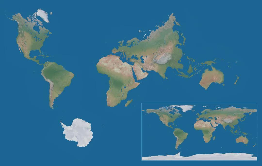
The 'True World Map with Correct Proportions of Continents' presents a fascinating and accurate depiction of our planet's landmasses, emphasizing the true sizes and shapes of continents relative to one another. Unlike traditional maps that often distort reality—like the commonly used Mercator projection—this visualization provides a more authentic view of how the world's continents are proportioned. This accuracy is crucial for understanding global geography more clearly.
However, such a map isn't just about aesthetics; it significantly impacts how we perceive and relate to different regions of the world. The misrepresentation of sizes can lead to misconceptions regarding the importance or size of various countries and continents. For instance, Africa is often portrayed as significantly smaller than it is, leading to a cultural and geographical misunderstanding of its vastness and diversity.
Deep Dive into Continental Sizes and Geographies
When discussing the true sizes of continents, it’s essential to highlight the often-overlooked fact that Africa is the second-largest continent, covering approximately 30.37 million square kilometers. This is nearly three times the size of Europe! What's fascinating is that this size allows for an incredible variety of climates, ecosystems, and cultures, ranging from the arid Sahara Desert to the lush forests of the Congo Basin.
In contrast, North America, with its roughly 24.71 million square kilometers, is often perceived as larger due to its prominent positioning in many traditional maps. This continent boasts diverse geographical features, including the Rocky Mountains, Great Plains, and extensive coastlines along both the Atlantic and Pacific Oceans.
Interestingly, the misconception of sizes extends to South America as well, which, at about 17.84 million square kilometers, is often overshadowed by its northern counterpart. This continent is home to the Amazon Rainforest, the largest tropical rainforest in the world, demonstrating that size isn't just about land area but also about ecological significance.
Australia, the smallest continent, measures around 7.69 million square kilometers, which may seem diminutive, yet it is rich in biodiversity and unique ecosystems. The Great Barrier Reef and various endemic species highlight the continent's ecological importance.
Lastly, Antarctica, while not a permanent resident of the human population, spans about 14 million square kilometers and holds about 60% of the world's fresh water, showcasing how crucial it is to global climate regulation despite its icy appearance.
Regional Analysis
Examining the regions represented in the True World Map allows us to appreciate the varying geographical and cultural landscapes. For instance, Africa, often unfairly labeled as a monolithic entity, consists of 54 sovereign countries, each with its own unique cultural heritage and environmental challenges. Countries like Nigeria and Egypt have substantial populations and rich histories that underscore their importance on the world stage.
In Europe, the contrast between smaller nations like Luxembourg and larger countries like France emphasizes how political and cultural significance often outweighs sheer size. Meanwhile, Asia, the largest continent at about 44.58 million square kilometers, encompasses an astonishing array of cultures, languages, and histories. Countries like China and India, with populations exceeding a billion, dominate discussions on global demographics and economic power.
Significance and Impact
Understanding the true proportions of continents matters more than merely satisfying our visual preferences; it shapes perceptions, policies, and interactions on a global scale. For educators, accurate maps serve as critical tools for teaching geography, helping students grasp not just where countries are located, but also their relative importance and size. Ever wondered why some nations seem larger in global discussions despite their smaller land area? It's largely due to misconceptions fostered by distorted maps.
Moreover, in the age of climate change, recognizing the true geographic extents of continents can inform our understanding of environmental issues. Countries in Africa, often depicted as less significant, are poised to be some of the most affected by climate change, which could lead to significant humanitarian and ecological crises.
As we move forward, the call for more accurate representations of our world on maps becomes increasingly essential. As geographers and map enthusiasts, we must advocate for visualizations that reflect the true nature of our planet, fostering a more informed global citizenry that understands the importance of every continent, country, and culture.
In conclusion, the 'True World Map with Correct Proportions of Continents' not only rectifies visual inaccuracies but also serves as a reminder of the interconnectedness of our world, urging us to appreciate the diversity and significance of every corner of our planet.
Visualization Details
- Published
- August 19, 2025
- Views
- 130
Comments
Loading comments...