De Facto Geopolitical Map of West Asia

Marcus Rodriguez
Historical Geography Expert
Marcus Rodriguez specializes in historical cartography and geographic data analysis. With a background in both history and geography, he brings unique...
Geographic Analysis
What This Map Shows
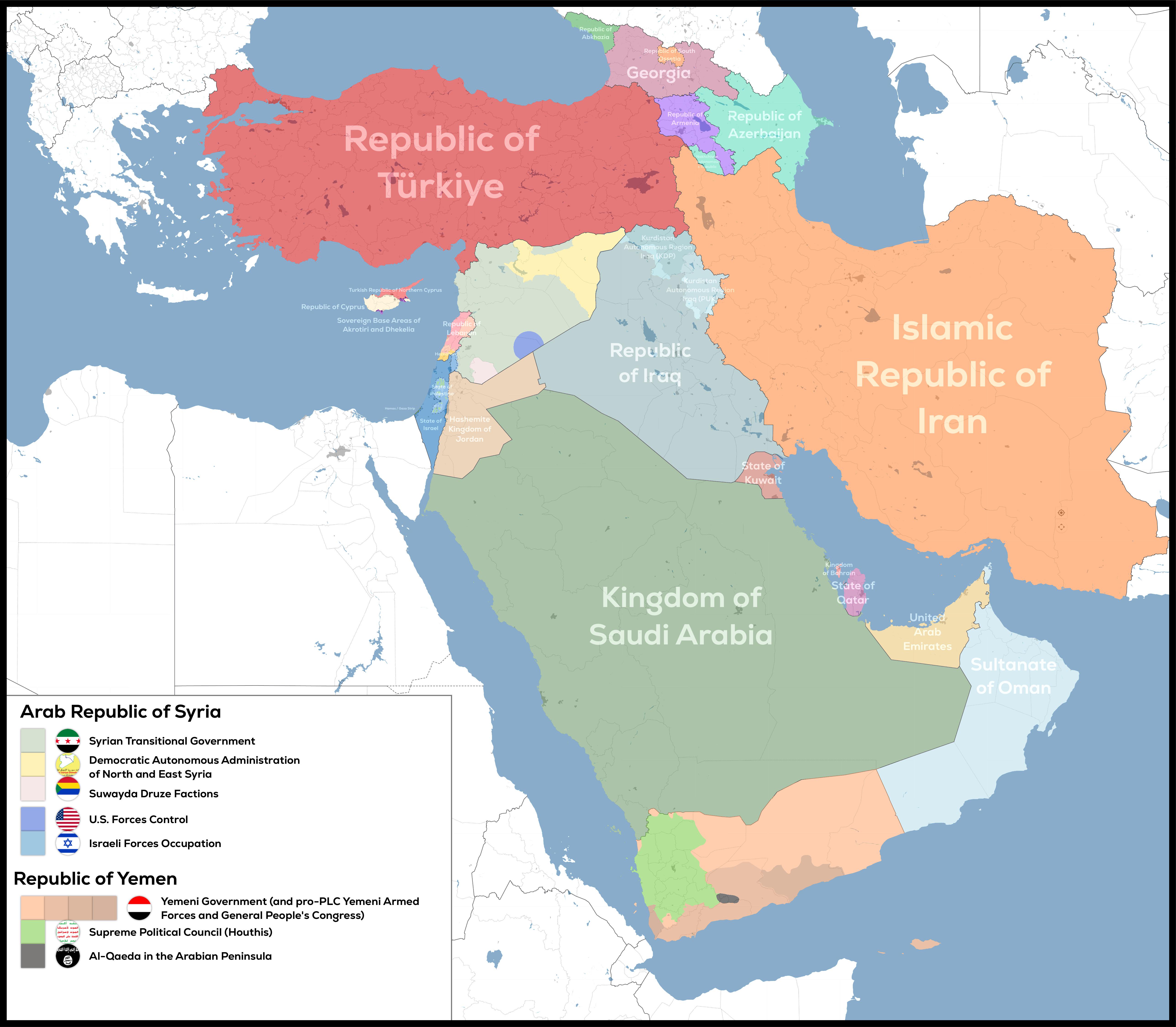
The "De-Facto Geopolitical Map of West Asia" provides a striking illustration of the current territorial control in this complex region. Unlike traditional maps that display internationally recognized borders, this visualization captures the reality of who controls what, regardless of legal status or diplomatic recognition. West Asia, a region steeped in history and conflict, showcases a tapestry of nations, ethnic groups, and geopolitical interests.
This map serves as a crucial tool for understanding the intricate dynamics at play. It highlights the areas of control by various states and non-state actors, including governments, militias, and other factions. For instance, the map unequivocally indicates the fragmented nature of authority in Syria, where multiple groups vie for dominance amid ongoing civil unrest.
Deep Dive into Territorial Control
Territorial control is a fundamental aspect of geopolitics, influencing national security, economic stability, and social structures. In West Asia, the de facto borders are often fluid, shifting with the ebb and flow of political power and conflict.
In countries like Iraq and Syria, the presence of various armed groups complicates the narrative of control. The rise of entities such as ISIS has altered power dynamics, with regions shifting hands frequently. For example, in Iraq, the map illustrates areas still controlled by Kurdish forces in the north, reflecting their significant autonomy and influence following the U.S. invasion in 2003. Interestingly, this Kurdish autonomy has often clashed with the ambitions of both the Iraqi government and neighboring Turkey, which views the Kurdish presence as a security threat.
Moreover, the Syrian civil war has created a patchwork of control where the Syrian government, backed by Russia and Iran, holds significant portions of territory, yet numerous opposition forces and Kurdish groups maintain control over other areas. The map vividly shows these divides, emphasizing the complexity of governance in a war-torn landscape.
Beyond military control, the de facto borders also impact resource distribution. For instance, the control of oil fields in northeastern Syria by the Syrian Democratic Forces (SDF) has significant implications for both local economies and international energy markets. The SDF's control over these resources has led to tensions with the Syrian government and neighboring Turkey, both of which have interests in the region.
Regional Analysis
Examining the West Asian regions depicted in the map reveals stark contrasts in territorial control. In the southern part, Yemen is embroiled in a multi-faceted conflict involving the Houthi movement, the internationally recognized government, and various other factions, including Al-Qaeda and ISIS. The map highlights the division of control between these groups, showcasing the humanitarian crisis that has ensued as a result.
In contrast, the Arabian Peninsula, particularly in countries like Saudi Arabia and the United Arab Emirates, shows a more stable governance structure, albeit with its own internal challenges, such as the ongoing tensions with Qatar and Iran.
Looking at Israel and Palestine, the map underscores the contentious nature of territorial claims. The areas under Palestinian control are fragmented and often surrounded by Israeli settlements, creating a complex and volatile situation that is the focal point of international diplomatic efforts.
On the other hand, the Gulf states, while having their own political intricacies, exhibit a relatively unified front against external threats, notably from Iran. This geopolitical cooperation is reflected in the map through the consistent control these nations maintain over their territories.
Significance and Impact
Understanding the de facto geopolitical landscape of West Asia is pivotal for several reasons. First, it provides insights into the ongoing conflicts and the shifting alliances that characterize the region. These dynamics have profound implications for global security, economic interests, and humanitarian efforts.
Current trends indicate a potential reconfiguration of alliances, especially in light of changing U.S. foreign policies and the increasing assertiveness of regional powers like Iran and Turkey. Interestingly, the normalization of relations between Israel and some Arab states demonstrates the evolving geopolitical landscape, which may further shift the control and influence within the region.
As the world watches these developments, the de facto borders illustrated in this map serve as a reminder of the realities on the ground, urging policymakers to consider the complex and often contradictory nature of territorial control in West Asia. With each shift in power and control, the map will undoubtedly evolve, reflecting the ongoing narrative of this historically rich yet tumultuous region.
Visualization Details
- Published
- August 19, 2025
- Views
- 124
Comments
Loading comments...