Urban Heat Islands Map of Frankfurt (2013-2024)

David Chen
Data Visualization Specialist
David Chen is an expert in transforming complex geographic datasets into compelling visual narratives. He combines his background in computer science ...
Geographic Analysis
What This Map Shows
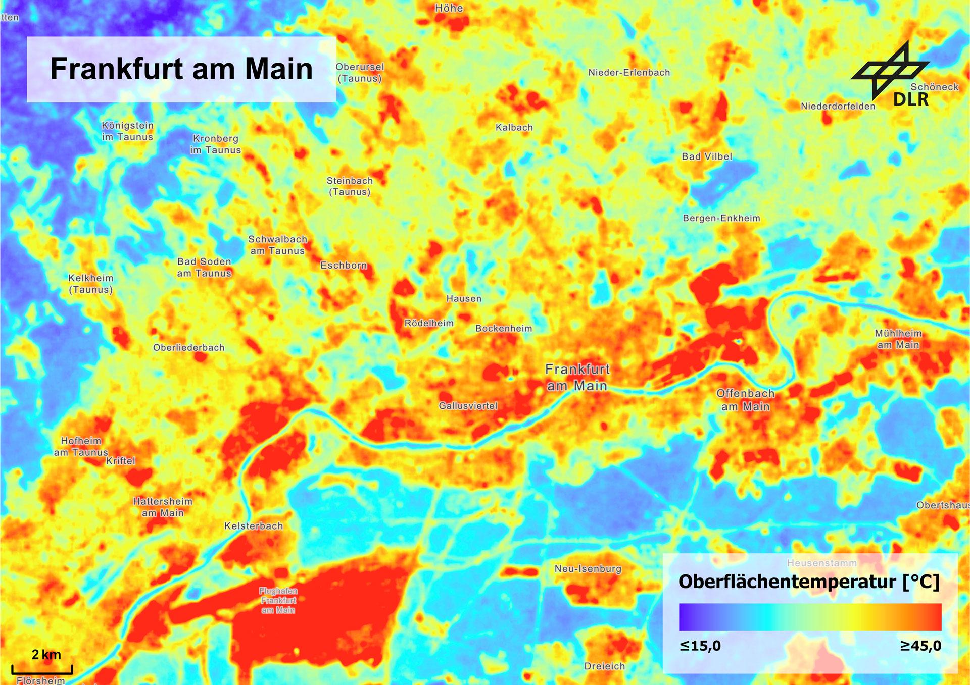
The map titled "How Urban Heat Islands Show Up in Frankfurt: Summer Surface Temperatures (2013–2024) Comparing Built vs. Non-Built Areas" provides a detailed visualization of temperature variations across Frankfurt during the summer months over an eleven-year period. Specifically, it highlights the stark contrast between built environments—such as roads, buildings, and other urban infrastructure—and non-built areas, including parks, forests, and bodies of water. As a result, this map reveals important insights into the phenomenon known as urban heat islands (UHIs).
Urban heat islands occur when urban regions experience significantly warmer temperatures than their rural surroundings. This effect results from human activities and the concentration of heat-absorbing materials in cities, such as asphalt and concrete. The map allows us to see how the temperature disparities evolve over time and how they correlate with urban development in Frankfurt.
Deep Dive into Urban Heat Islands
Urban heat islands are an increasingly pressing concern in metropolitan areas worldwide. The UHI effect is largely driven by several factors: the absorption of solar energy by buildings and pavements, reduced vegetation cover, and the release of waste heat from vehicles and buildings. Interestingly, studies have shown that urban areas can be up to 5-7 degrees Celsius warmer than surrounding rural regions during peak summer months.
In Frankfurt, the situation is no different. The map indicates that the city's densely built areas, particularly the central business district, exhibit significantly higher summer surface temperatures. For instance, while green spaces like the Palmengarten or the extensive parks along the Main River show relatively cooler temperatures, urbanized zones can reach alarming highs. In fact, temperatures in built areas have been recorded at over 40 degrees Celsius on particularly hot days, a stark contrast to the cooler microclimates found in the city’s parks.
What’s fascinating is that this heat disparity is not just a concern for comfort; it also has implications for public health, energy consumption, and environmental quality. Increased temperatures can exacerbate air pollution, leading to respiratory issues, heat strokes, and other health problems. Moreover, as temperatures rise, energy demands for cooling systems increase, leading to higher electricity consumption and subsequent greenhouse gas emissions.
Regional Analysis
When analyzing the map in detail, we can observe significant temperature variations across different districts in Frankfurt. For instance, the district of Innenstadt, characterized by high-density development, consistently shows some of the highest temperature readings. In contrast, neighborhoods like Sachsenhausen, which feature more green spaces and lower building densities, tend to maintain cooler temperature averages, showcasing the effectiveness of vegetation in mitigating UHI effects.
Additionally, the map illustrates the ongoing development trends in Frankfurt. Areas like Westend, which have seen increased residential and commercial development, reflect rising surface temperatures. Conversely, neighborhoods that have retained their green characteristics, such as Bockenheim, display more moderate temperatures. This juxtaposition emphasizes the importance of urban planning that incorporates green spaces to combat the UHI phenomenon.
Significance and Impact
Understanding urban heat islands is crucial for city planners, environmentalists, and public health officials alike. With climate change intensifying, the risks associated with UHIs are projected to worsen. Urban areas are expected to experience higher temperatures, which can lead to an increase in heat-related illnesses, particularly among vulnerable populations such as the elderly and those with pre-existing health conditions.
Moreover, the implications extend beyond health; they influence social equity. Disadvantaged neighborhoods often lack sufficient green space, exacerbating the heat effects and creating disparities in health outcomes. As cities like Frankfurt continue to grow, it becomes increasingly essential to prioritize sustainable urban design that incorporates natural elements to mitigate these effects.
In summary, the insights gained from the map of urban heat islands in Frankfurt provide a critical lens through which to view urban development and its environmental impacts. The challenge ahead lies in balancing growth with sustainability, ensuring that cities remain livable and resilient as climate conditions continue to evolve. Have you noticed similar patterns in your own city? The conversation around urban heat islands is not just about temperatures; it's about creating sustainable environments for future generations.
Visualization Details
- Published
- August 17, 2025
- Views
- 106
Comments
Loading comments...