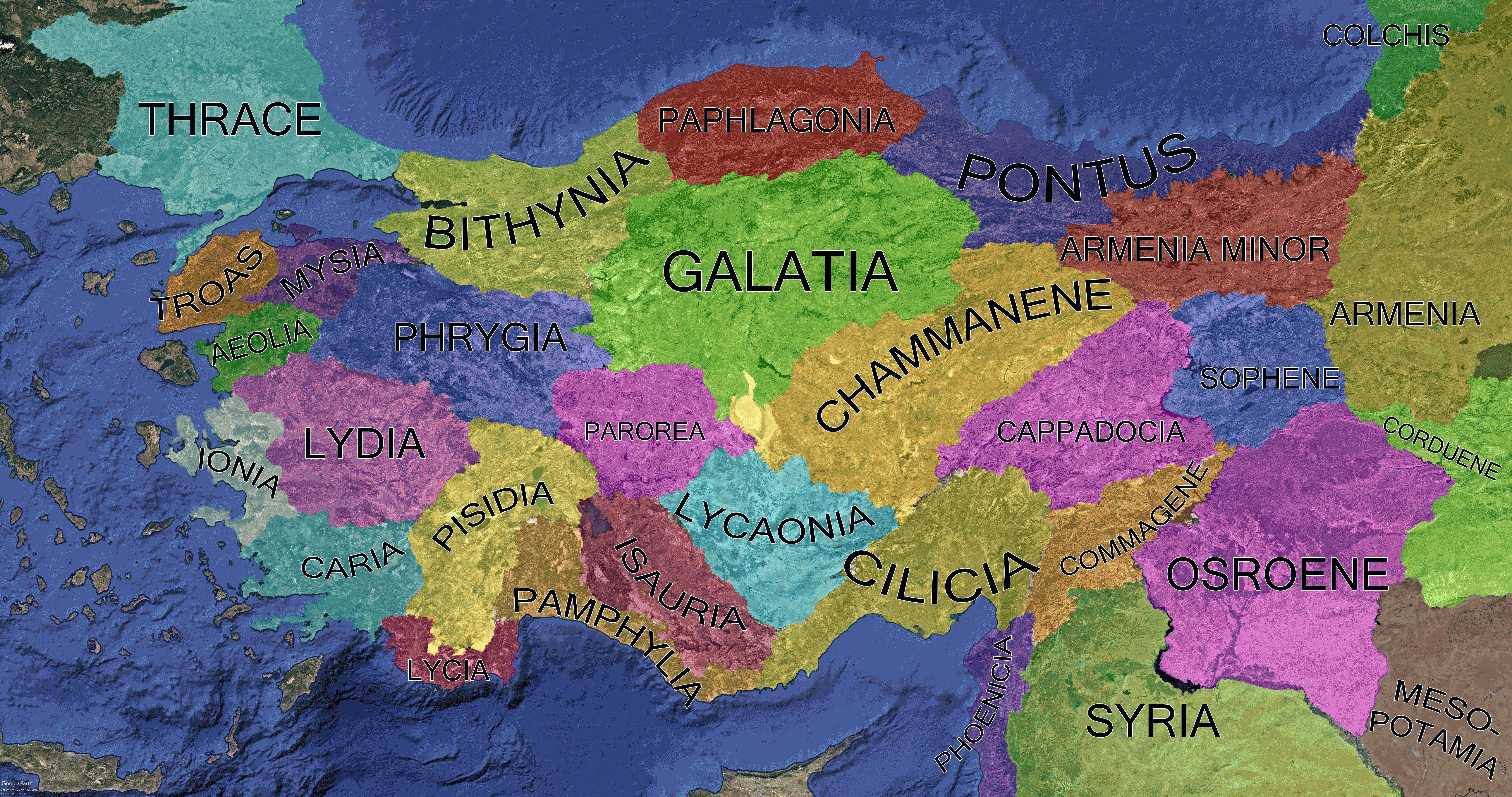
Anatolia Asia Minor Regions Map 200 BCE


Marcus Rodriguez
Historical Geography Expert
Marcus Rodriguez specializes in historical cartography and geographic data analysis. With a background in both history and geography, he brings unique...
Geographic Analysis
What This Map Shows
This detailed map illustrates Anatolia, also known as Asia Minor, during the Greco-Roman period, specifically around 200 BCE. It highlights the classical regions within this fascinating territory, as well as their natural borders, providing a vivid snapshot of how these regions were defined by both human and physical geography. You can see the significant influence of mountains, rivers, and coastlines in shaping these classical regions, which played a crucial role in the cultural and political dynamics of the time.
Deep Dive into the Geography of Anatolia
Anatolia is a rugged peninsula that connects Europe and Asia, and its geography has profoundly shaped its history and development. The landscape is characterized by a mix of mountainous regions, fertile plains, and coastal areas, each influencing the settlement patterns of various peoples throughout history. One of the most significant geographical features is the central Anatolian plateau, bordered by the Pontic Mountains to the north and the Taurus Mountains to the south. Interestingly, these mountain ranges not only provided natural barriers but also influenced climate patterns in the region.
The rivers of Anatolia, such as the Halys (Kızılırmak), Meander (Menderes), and the Cydnus (Tarsus), were vital for agriculture and trade, facilitating communication and commerce among the classical regions. The Halys River, for example, served as a natural boundary between different territories and was essential for the agricultural productivity of the Hittite and Phrygian kingdoms. The Meander River, with its characteristic winding course, is famed for its lush banks and dense settlements, which thrived on the fertile alluvial plains.
What's fascinating is that these rivers also played a role in mythology and literature, inspiring stories that have echoed through centuries. The interplay between the natural landscape and human activity is a defining characteristic of Anatolia's history.
The Mediterranean coast, with its mild climate and rich marine resources, supported thriving port cities like Ephesus and Miletus, which became centers for trade, culture, and philosophy. The Aegean Sea to the west and the Black Sea to the north provided not only trade routes but also strategic military advantages, influencing various powers from the Greeks to the Romans.
Regional Analysis
The map of Anatolia clearly delineates several key regions during the Greco-Roman period:
1. **Lydia**: Located in western Anatolia, Lydia was known for its wealth and luxury, largely derived from its gold resources. The capital, Sardis, exemplified urban development with impressive fortifications and monumental architecture.
2. **Phrygia**: Situated in central Anatolia, Phrygia's economy relied heavily on agriculture and livestock, benefiting from fertile lands nurtured by the rivers flowing from the surrounding mountains. The Phrygian capital, Gordium, was strategically located along major trade routes, enhancing its significance.
3. **Caria**: This region is noted for its rugged terrain, which led to the development of fortified cities like Halicarnassus. Interestingly, Caria's coastal position meant it was heavily influenced by maritime trade and cultural exchanges with neighboring regions.
4. **Bithynia**: Located in the northwest, Bithynia served as a vital link between the Greek world and the interior of Anatolia. Its cities, such as Nicomedia, became important political and cultural centers.
5. **Pontus**: The northern region of Pontus was characterized by its mountainous landscape and access to the Black Sea, making it crucial for trade with regions further north. The diverse geography allowed for varied agricultural practices, which supported local populations.
Each of these regions exhibited unique characteristics shaped by their geography, influencing their development and interactions with one another.
Significance and Impact
Understanding the geography of Anatolia during the Greco-Roman period is not just an academic exercise; it has real-world implications for how we view the historical flow of culture, trade, and human migration. The natural borders defined by mountains and rivers shaped political boundaries and cultural identities, affecting everything from military strategies to trade routes.
Today, as we explore the remnants of these ancient civilizations, the geography of Anatolia continues to impact modern Turkey. The strategic location of Anatolia, bridging Europe and Asia, remains significant in contemporary geopolitics. Furthermore, the region's agricultural potential and diverse ecosystems are critical in addressing current global challenges, such as food security and environmental sustainability.
In conclusion, the map of Anatolia/Asia Minor during the Greco-Roman period serves as a window into understanding how geography can influence human history. The interplay of natural landscapes and human settlement continues to resonate in our modern world, making this a topic of enduring relevance.
Visualization Details
- Published
- August 17, 2025
- Views
- 268
Comments
Loading comments...