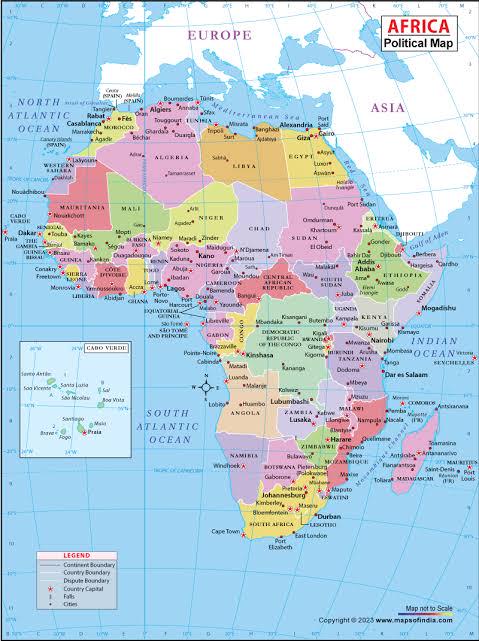
Equal Earth Projection Map for Africa


Alex Cartwright
Senior Cartographer & GIS Specialist
Alex Cartwright is a renowned cartographer and geographic information systems specialist with over 15 years of experience in spatial analysis and data...
Geographic Analysis
What This Map Shows
The visualization titled "African Union Calls for a Fairer World Map" showcases the implications of shifting from the traditional Mercator projection to the more accurate Equal Earth projection. While the Mercator map has long been the standard for representing the world, it distorts the sizes of continents, particularly underrepresenting Africa and South America. The Equal Earth projection, on the other hand, seeks to provide a more proportional representation of land masses, accurately reflecting their true size and significance on a global scale. This is particularly vital for understanding geopolitical dynamics, economic relationships, and cultural contexts.
Deep Dive into the Importance of Accurate Map Projections
Maps are not just tools for navigation; they shape our perceptions of reality. The choice of map projection can influence everything from educational content to international relations. The Mercator projection, developed in 1569, was primarily designed for maritime navigation. However, its cylindrical nature exaggerates the size of land masses closer to the poles, leading to a skewed perception of global geography. For example, Greenland appears much larger than it actually is relative to Africa, which is significantly more expansive.
Interestingly, many people may not realize that Africa is not only the second-largest continent but also holds immense cultural, economic, and natural wealth. It covers about 30.2 million square kilometers, making it larger than the combined areas of the United States, China, and India! Such misrepresentations can reinforce stereotypes and misconceptions about the continent, undermining its importance in global discussions.
The Equal Earth projection, endorsed by the African Union and supported by organizations like Africa No Filter and Speak Up Africa, aims to correct these misconceptions. By accurately representing Africa's size and position, this projection can help in reshaping narratives that often minimize the continent's role on the world stage. Furthermore, teaching this new perspective in schools could lead to a generation that views Africa as it truly is — a vital and influential player in global affairs.
Regional Analysis
When we break down the implications of using the Equal Earth projection by regions within Africa, we can see significant differences in how the continent is perceived. For instance, the North African region, which includes countries like Egypt, Libya, and Algeria, is often seen through a Mediterranean lens, focusing on its historical ties to Europe. However, this overlooks the vast deserts and the rich cultures of Sub-Saharan Africa, which includes West, East, and Southern Africa.
In West Africa, countries like Nigeria and Ghana play crucial roles in the continent's economy and politics. Nigeria, being the most populous country in Africa with over 200 million residents, is a powerhouse in terms of both population and resources. The Equal Earth projection emphasizes the size of these countries and their potential influence on regional stability and growth.
Similarly, in East Africa, the significance of the Great Rift Valley and nations like Kenya and Ethiopia is often overshadowed by the focus on North Africa. The region is not only rich in biodiversity but also crucial for international trade routes, especially with the growth of the African Union and initiatives aimed at boosting intra-African trade.
Southern Africa, home to South Africa, Zimbabwe, and Mozambique, showcases a wealth of natural resources and economic potential. However, the historical context of these nations often leads to narratives that ignore their contributions to global economics and culture. By utilizing the Equal Earth projection, these regions can be presented more accurately, helping to foster a better understanding of their roles on the international stage.
Significance and Impact
The push for adopting the Equal Earth projection is significant beyond mere aesthetics. It represents a broader movement towards equity and representation in global discussions. Inaccurate maps perpetuate stereotypes and inhibit meaningful dialogues about Africa's potential and challenges. By promoting a map that correctly depicts the continent's size and significance, the African Union and its supporters aim to shift the narrative around Africa from one of marginalization to one of empowerment.
This initiative also has real-world implications for policy-making and international relations. As countries and organizations begin to adopt the Equal Earth projection, we may see a shift in how decisions are made regarding trade agreements, developmental aid, and environmental policies. The goal is to create a more balanced perspective that recognizes Africa's contributions and challenges, ultimately leading to better collaboration and mutual respect on the global stage.
As we move forward, it's crucial to understand the power of representation in shaping our worldviews. The Equal Earth projection is not just a new way to visualize geography; it’s a catalyst for change, pushing us towards a more just and equitable understanding of our planet. Have you noticed how different perspectives can influence your understanding of global issues? It's time we embrace a map that reflects the world as it truly is, starting with a fair representation of Africa.
Visualization Details
- Published
- August 16, 2025
- Views
- 204
Comments
Loading comments...