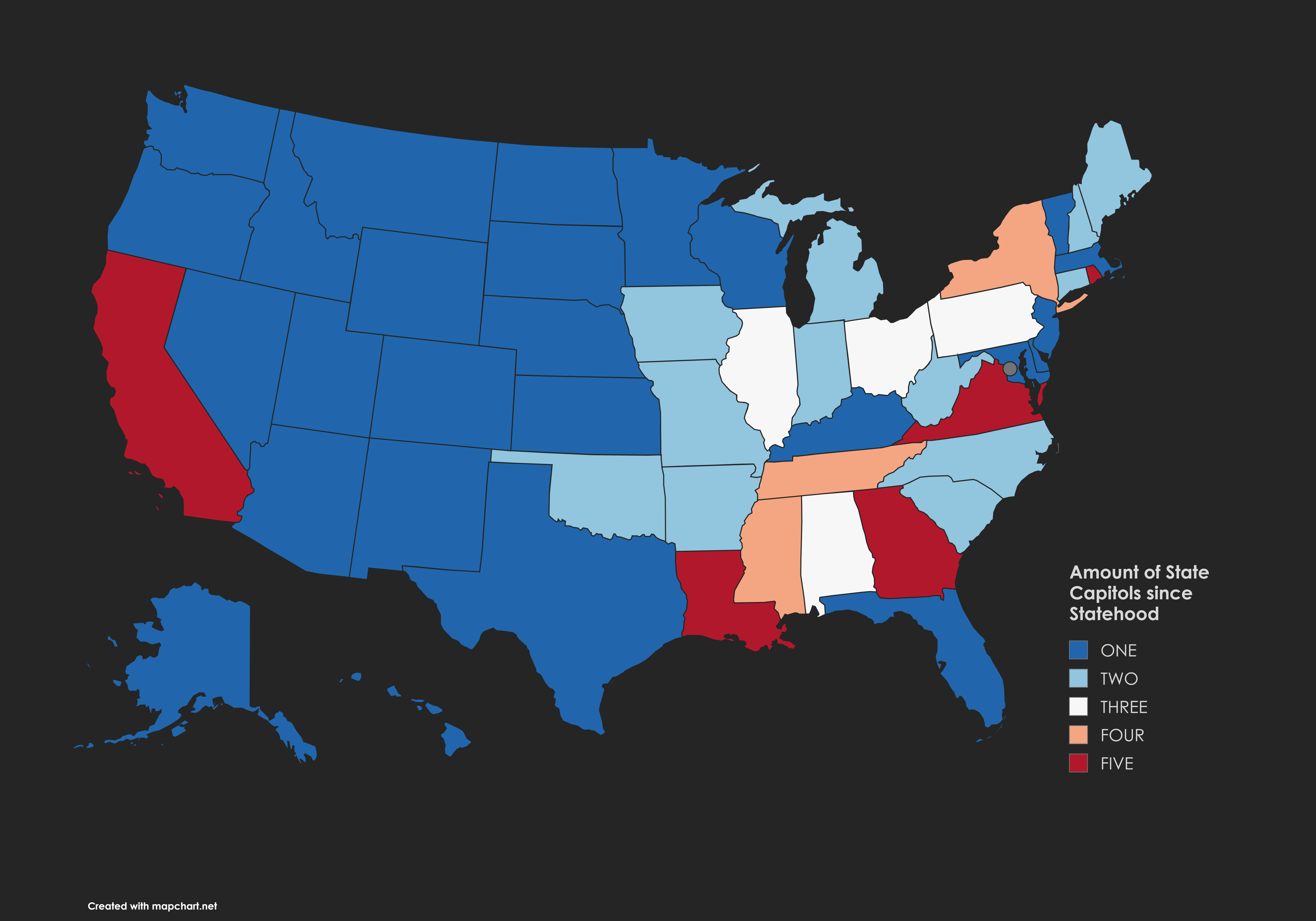
Map of State Capitols Since Statehood

David Chen
Data Visualization Specialist
David Chen is an expert in transforming complex geographic datasets into compelling visual narratives. He combines his background in computer science ...
Geographic Analysis
What This Map Shows
The "Amount of State Capitols Since Statehood" map provides a visual representation of the number of state capitals that have existed in each U.S. state since their respective admissions into the Union. This map highlights the historical evolution of governance in the United States, showcasing how state capitals have shifted, changed, or remained stable over time. Understanding the dynamics of state capitals is crucial to grasping the broader narrative of American political history.
Deep Dive into State Capitals
State capitals serve as the political heart of each state, often embodying its history, culture, and governance structure. Interestingly, the number of capitals a state has had can reflect various historical events, economic shifts, and social changes. For instance, many states established their capitals in locations that were once strategic for trade or defense during the early days of the Republic. Over time, as populations grew and transportation improved, some capitals were moved to more central locations or to cities that could better accommodate the needs of a growing populace.
Take, for example, the state of New York. It originally established its capital in Kingston in 1777 but moved it to Albany in 1797, where it remains today. Albany's location along the Hudson River made it a more strategic choice for trade and governance, solidifying its role as a center for political activity in the region. Conversely, the admission of new states often resulted in the establishment of new capitals. In the case of Arizona, Phoenix was designated the capital in 1889, reflecting the state's rapid growth as a result of the late 19th-century mining boom.
Additionally, the topic of state capitals often intersects with discussions about urban development and demographics. Many state capitals are among the largest cities in their states, acting as hubs for business, culture, and education. However, this is not universally true. For example, Montpelier, Vermont, is the least populated state capital in the U.S. This highlights how state capitals can sometimes be chosen for political rather than demographic reasons, reflecting a diverse landscape of governance across the nation.
What's fascinating is that the frequency of capital changes can also be indicative of political instability or conflict. States like Louisiana, which has had its capital shifted between New Orleans and Baton Rouge, show how historical events such as wars or natural disasters can impact governance. In 1825, Baton Rouge was chosen to be the permanent capital due to concerns over flooding and the growing importance of the area as a political center.
Regional Analysis
When analyzing the map regionally, certain patterns emerge. For example, states in the Midwest often have a higher frequency of capital changes compared to those in the South or Northeast. The Midwest, with its agricultural roots and evolving economy, saw capitals move in response to population shifts and industrialization. Illinois, for instance, moved its capital from Kaskaskia to Vandalia, and finally to Springfield in 1839, reflecting its growth and the need for a centrally located capital.
In contrast, Southern states have tended to maintain their capitals longer, often due to historical ties and a strong sense of tradition. For instance, Montgomery has been Alabama's capital since 1846, reflecting the state's rich history and cultural significance. This stability can be attributed to factors such as the state's historical figures and events that are deeply intertwined with the capital’s identity.
Interestingly, the Western states, which were predominantly formed during the westward expansion, show a mix of both stability and change. States like California have experienced shifts in capitals, with Sacramento being the current capital since 1854, chosen for its accessibility to the growing population driven by the Gold Rush. However, other states like Nevada have remained consistent in their capital selection, with Carson City serving since its statehood in 1864.
Significance and Impact
Understanding the evolution of state capitals matters for various reasons. Historically, the location of a capital has often mirrored the political and economic priorities of the time. As cities grow and change, the significance of having a capital in a particular location can directly affect governance, resource distribution, and public administration.
Furthermore, the historical context surrounding state capitals can provide insights into broader trends in American history, such as migration patterns, economic booms, and even social movements. For instance, the movement of capitals often coincides with the shifts in population due to industrialization, as seen in the changes in the Midwest and West.
Looking to the future, it’s worth considering how the evolution of state capitals might continue to reflect changes in society. With increasing urbanization and the rise of technology, will we see a push for more decentralized forms of governance? As remote communication becomes more prevalent, the physical location of a capital might become less significant, prompting shifts we cannot yet predict.
In summary, the "Amount of State Capitols Since Statehood" map is not just a reflection of where state governments reside but a window into the evolution of American governance and the factors that influence where power is centered.
Visualization Details
- Published
- August 15, 2025
- Views
- 112
Comments
Loading comments...