3-D Relief Map of South America

Alex Cartwright
Senior Cartographer & GIS Specialist
Alex Cartwright is a renowned cartographer and geographic information systems specialist with over 15 years of experience in spatial analysis and data...
Geographic Analysis
What This Map Shows
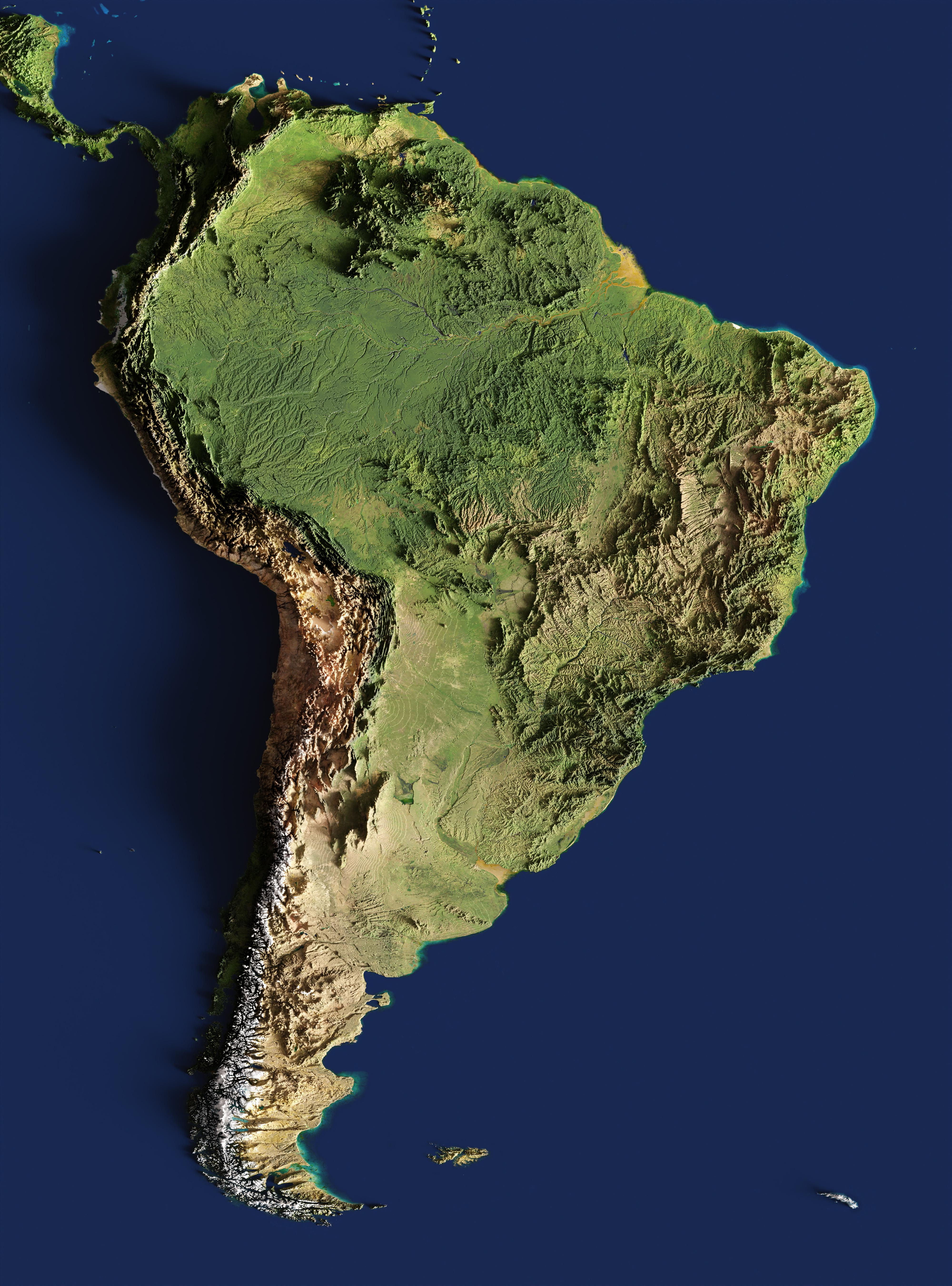
The 3-D relief map of South America provides a striking visual representation of the continent’s topography. This three-dimensional view highlights the dramatic variations in elevation, showcasing mountain ranges, valleys, and plateaus in a way that flat maps simply cannot. From the towering Andes to the expansive Amazon Basin, this map captures the physical landscape that shapes the region’s ecology, climate, and human activities.
Deep Dive into South America's Topography
South America is home to some of the world's most impressive geographical features. The Andes Mountains, which stretch over 7,000 kilometers along the western edge of the continent, are the longest continental mountain range on Earth. These mountains are not just a geographical barrier; they influence weather patterns and biodiversity across the continent. Interestingly, the Andes are made up of multiple ranges, including the Northern Andes and the Southern Andes, each with unique characteristics and ecosystems.
The highest peak, Aconcagua, reaches an elevation of 6,961 meters (22,838 feet) and is a significant landmark not just for climbers, but also for understanding the climatic variations across the region. The elevation drop from the Andes into the Amazon Basin creates diverse climates, leading to the lush rainforests that dominate much of northern South America.
Have you ever wondered why the Amazon River is so significant? Its basin, covering around 5.5 million square kilometers, is the largest rainforest on the planet and plays a crucial role in global water cycles. The river itself is the second longest in the world, flowing over 4,000 kilometers from the Andes to the Atlantic Ocean. Notably, the Amazon River and its tributaries are vital for both biodiversity and local communities, supporting countless species and serving as a primary transportation route.
In contrast, the eastern parts of South America, particularly Brazil, feature vast plateaus and coastal plains. The Brazilian Highlands, for example, are characterized by their rolling hills and numerous rivers. This area is essential for agriculture, particularly for the cultivation of coffee, soybeans, and sugarcane, which are significant to both local economies and global markets.
Regional Analysis
Examining South America through the lens of its topography reveals distinct regional characteristics. In the northwest, countries like Peru and Bolivia showcase the harsh, rugged terrain of the Andes, with significant altitudinal variations influencing settlement patterns. Cities like La Paz, situated at over 3,600 meters (11,800 feet), demonstrate how human habitation adapts to extreme elevations.
Moving northeast into Brazil, the terrain transitions to the low-lying Amazon Basin, where the flat, fertile land supports a different kind of life. Here, rainfall is abundant, and the flatness of the land allows for extensive agricultural practices. However, this area also faces challenges such as deforestation and climate change, which threaten its ecological balance.
In southern regions, such as Argentina and Chile, the landscape shifts once more. Patagonia, known for its dramatic mountains and glaciers, is a stark contrast to the fertile plains of the Pampas in Argentina. This diversity in terrain not only affects agriculture and urban development but also plays a role in tourism, with different regions attracting visitors for their unique natural beauty.
Significance and Impact
Understanding the topography of South America is more than just an academic exercise; it has real-world implications. The continent’s geographical features influence climate, biodiversity, and human settlement patterns. For instance, as climate change continues to impact weather patterns globally, regions like the Andes are experiencing rapid glacial melting, which has implications for water supply in surrounding areas.
Moreover, the Amazon rainforest is under threat from deforestation and industrial development. The topography, which supports rich biodiversity, is crucial for carbon storage and mitigating climate change effects. Protecting these landscapes is not just about preserving nature; it’s about ensuring a sustainable future for millions of people who depend on these ecosystems.
In conclusion, the 3-D relief map of South America serves as a powerful reminder of the continent's complex and varied geography. From the peaks of the Andes to the depths of the Amazon, understanding these features helps us appreciate the interconnectedness of our environment and the importance of protecting it for future generations.
Visualization Details
- Published
- August 14, 2025
- Views
- 118
Comments
Loading comments...