Albigensian Crusade Geography Map

David Chen
Data Visualization Specialist
David Chen is an expert in transforming complex geographic datasets into compelling visual narratives. He combines his background in computer science ...
Geographic Analysis
What This Map Shows
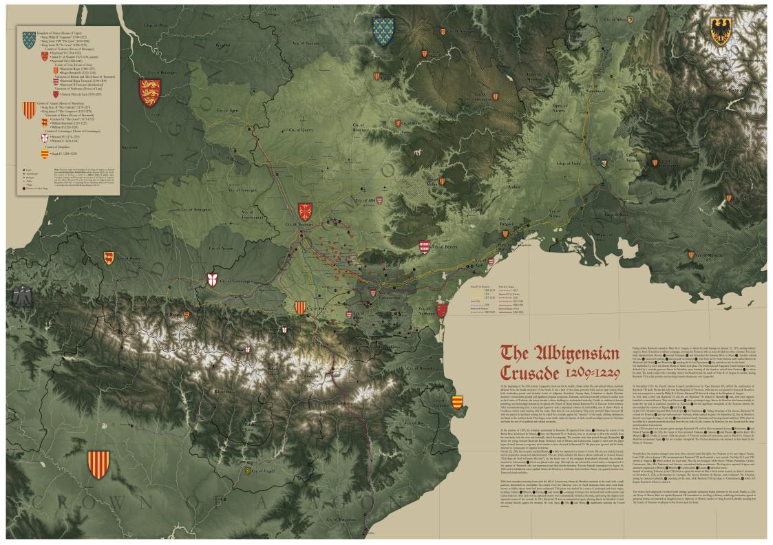
The highly detailed map of the Albigensian Crusade (1209–1229) serves as a visual representation of the significant geographical elements involved in this medieval conflict. Based on Jonathan Sumption's book "The Albigensian Crusade," the map captures a rich tapestry of cities, castles, abbeys, dioceses, and the routes that were crucial to military movements and religious influence during this turbulent period. By integrating data from contemporary chronicles, medieval cartography, and modern historical research, this visualization offers an insightful glimpse into the geographical landscape of Southern France during the crusade.
Deep Dive into the Albigensian Crusade
The Albigensian Crusade was launched by the Catholic Church against the Cathars, a Christian sect deemed heretical. This conflict unfolded across various regions of Southern France, primarily in the Languedoc area, which was known for its diverse geography. The terrain included the rolling hills of the Tarn region, the fortified cities like Carcassonne, and the rich agricultural lands that were crucial for sustaining the armies.
Interestingly, the geography of the region played a pivotal role in the conflict. The map highlights key locations such as Toulouse, a major stronghold of the Cathars, and Montségur, famous for its dramatic castle that became a symbol of resistance. The strategic positioning of these sites is significant; many were situated atop hills or near rivers, making them defensible against siege tactics employed by the Crusaders.
The routes plotted on the map illustrate how the Crusade's military campaigns were influenced by the topography. For instance, the Crusaders often utilized the Rhône River for transportation, while the mountainous regions posed challenges for troop movements. This interplay of geography and military strategy is a fascinating aspect of the Albigensian Crusade, as it reveals how terrain could dictate the success or failure of military endeavors.
Moreover, the involvement of religious institutions such as abbeys and dioceses is crucial to understanding the social fabric of the region. The map marks significant abbeys, which served not just as spiritual centers but also as logistical hubs for the Crusaders. The efforts to eradicate Catharism were deeply intertwined with the geography of these ecclesiastical sites, as they provided both sanctuary for the faithful and resources for the campaigns.
Regional Analysis
The map breaks down the regions of Southern France into distinct areas, each with its unique geographical features and historical significance. For example, in the west, the region of Aquitaine had a more varied landscape, with both fertile valleys and fortified towns. This diversity allowed for different military strategies and alliances.
In contrast, the Languedoc region, marked by its vineyards and fortified cities, became a focal point for the Crusaders. Cities like Béziers and Carcassonne were sites of brutal sieges, and their locations on the map illustrate how their geographical positioning influenced the Crusade's course. Have you noticed how the landscapes of these cities contributed to their defenses? The steep walls and natural barriers often helped in delaying Crusader advances.
Furthermore, the southernmost areas, such as Provence, faced different challenges. The geography here included Mediterranean coastal plains, which facilitated naval support for the Crusaders. This regional analysis not only showcases the diversity of landscapes but also emphasizes the varying degrees of resistance encountered across Southern France.
Significance and Impact
Understanding the geography of the Albigensian Crusade is crucial for comprehending the broader implications of this conflict. The Crusade was not merely a religious war; it reshaped the political landscape of Southern France and influenced the relationship between the Church and the state. The territorial gains made during the Crusade led to the consolidation of power for the French monarchy, effectively altering the region's governance.
Interestingly, the legacy of the Albigensian Crusade can still be seen today. The ruins of castles like Montségur are now historical sites that attract tourists and history buffs alike. They serve as reminders of a tumultuous past shaped significantly by geography. As we look forward, the lessons learned from this period can inform our understanding of contemporary conflicts influenced by geographical and cultural divides.
In conclusion, the detailed map of the Albigensian Crusade not only provides a visual representation of this historical conflict but also serves as a gateway into exploring how geography shapes human events. Whether you're a history enthusiast or a map lover, the intricate connections between terrain, strategy, and society in the Albigensian Crusade offer rich material for further exploration in future historical maps.
Visualization Details
- Published
- August 14, 2025
- Views
- 120
Comments
Loading comments...