1959 Geographic Center of the United States Map

David Chen
Data Visualization Specialist
David Chen is an expert in transforming complex geographic datasets into compelling visual narratives. He combines his background in computer science ...
Geographic Analysis
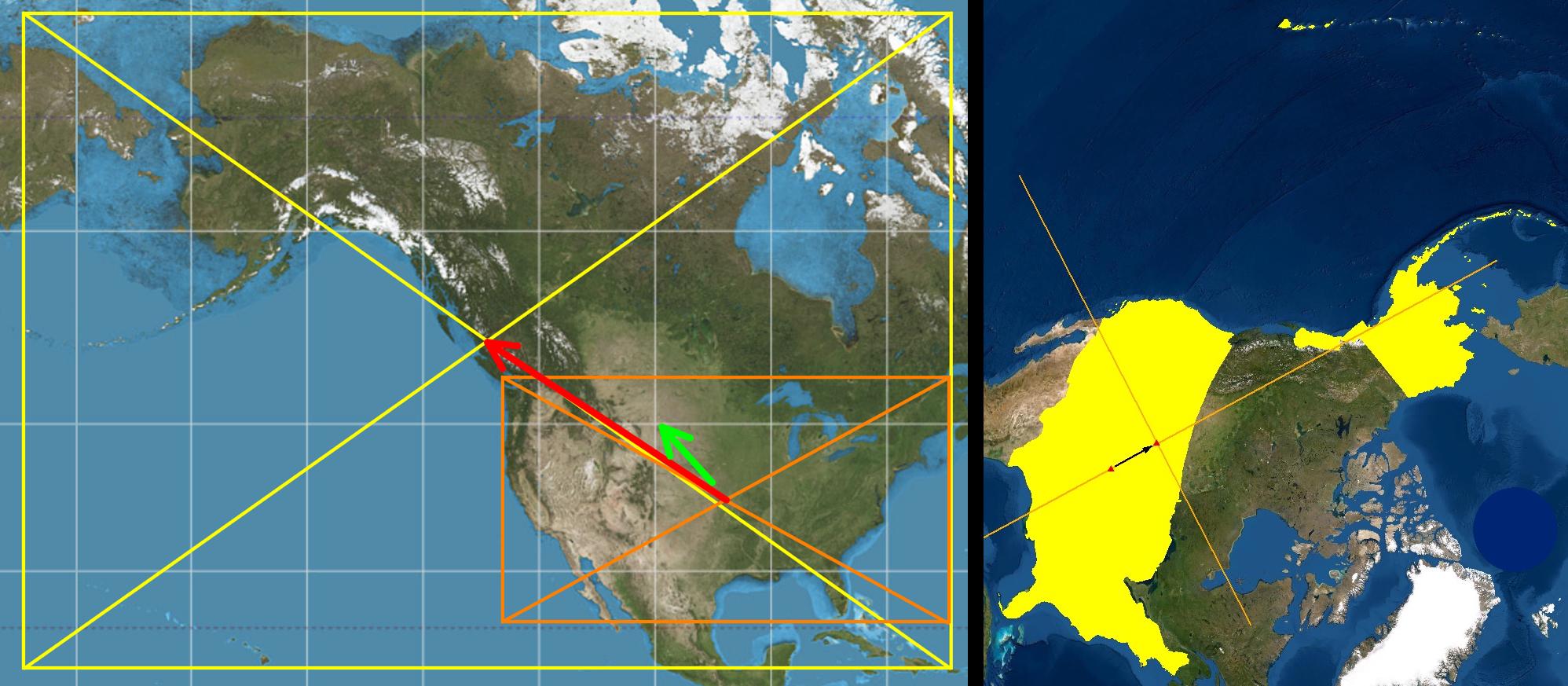
What This Map Shows\nThis map provides a fascinating visual representation of the shift in the geographic center of the United States following the admission of Alaska and Hawaii as states in 1959. Prior to this significant event, the geographic center was located near Lebanon, Kansas. However, upon the inclusion of these two states, the center moved approximately 354 miles northward and 265 miles westward to near Belle Fourche, South Dakota. The visualizations on the left and right employ different map projections to illustrate this shift clearly, showcasing how conventional map views can sometimes mislead our perceptions of geographical relationships.
Deep Dive into the Geographic Center of the United States\nThe concept of the geographic center of a landmass, often referred to as its centroid, is not merely a mathematical curiosity but an interesting way to understand the spatial dynamics of a country. The geographic center is determined based on the outline of the contiguous land area, and in the case of the United States, this means considering the geographical extent of all fifty states.
What’s particularly intriguing about the 1959 shift is how it reflects the broader geopolitical changes occurring within the United States at the time. The admission of Alaska and Hawaii not only altered the physical geography of the nation but also represented a significant expansion of U.S. territory into the Pacific and Arctic regions. This expansion had profound implications for national identity, economic development, and even military strategy during the Cold War era.
Interestingly, many people often assume the shift would have been more pronounced to the west, primarily due to the way maps are traditionally oriented with north at the top. This can lead to misconceptions about the distances involved. The effective shift northward was about 33% greater than the westward move, which can be surprising to those who visualize the geographic layout of the U.S. on a standard Mercator projection. In reality, the map on the left shows the bounding rectangles pre- and post-1959, emphasizing the significant northward movement as a result of Alaska's positioning.
Understanding the geographic center is also crucial for various fields including logistics, urban planning, and environmental studies. For instance, the geographic center can impact transportation networks, resource allocation, and even the distribution of population centers across the country. As the center of gravity shifts, so too can the focus of infrastructure development and economic investment.
Regional Analysis\nBreaking this topic down regionally provides even deeper insights. The shift to Belle Fourche, South Dakota, reflects not only a change in coordinates but also a transformation in how different regions of the country interact with one another. The Midwest, previously seen as the geographical heart of the nation, has seen its centrality challenged by the addition of states that are situated in far-flung corners of the country.
For example, Alaska, with its vast land area and low population density, contrasts sharply with Hawaii's compact size and high population density. This juxtaposition highlights the diverse geographic and demographic realities within the U.S. and how they intersect at the geographic center. The states of the Midwest now share this center with regions that are geographically far apart but play critical roles in the national landscape.
Furthermore, the impact of this shift can be observed in how infrastructure projects are planned. As the geographic center moves, cities and states might find themselves needing to recalibrate their transportation and economic strategies to better connect with areas that are now more 'central' to the nation’s geography.
Significance and Impact\nThe implications of the 1959 shift in the geographic center are far-reaching. Understanding this change helps underscore how geographical perceptions can shape economic, political, and social dynamics within the United States. As we navigate through the 21st century, the geographic center continues to serve as a symbolic reference point for discussions about national identity and unity.
Moreover, with ongoing discussions regarding statehood for territories like Puerto Rico and Washington D.C., the geographic center could potentially shift again, prompting a reevaluation of not only geographical but also political representation. As populations grow and migrate, and as climate change continues to influence where people choose to live, the geographic center may continue to reflect the evolving nature of the United States.
In conclusion, the 1959 shift in the geographic center of the United States is more than just a change in coordinates; it is a reflection of the dynamic and evolving nature of the nation itself. The maps serve as a visual reminder of this evolution, challenging us to reconsider our perceptions of geography while engaging with the real-world implications that come with it.
Visualization Details
- Published
- August 9, 2025
- Views
- 108
Comments
Loading comments...