Map of Most Frequently Occurring Natural Disasters by US County

Marcus Rodriguez
Historical Geography Expert
Marcus Rodriguez specializes in historical cartography and geographic data analysis. With a background in both history and geography, he brings unique...
Geographic Analysis
What This Map Shows
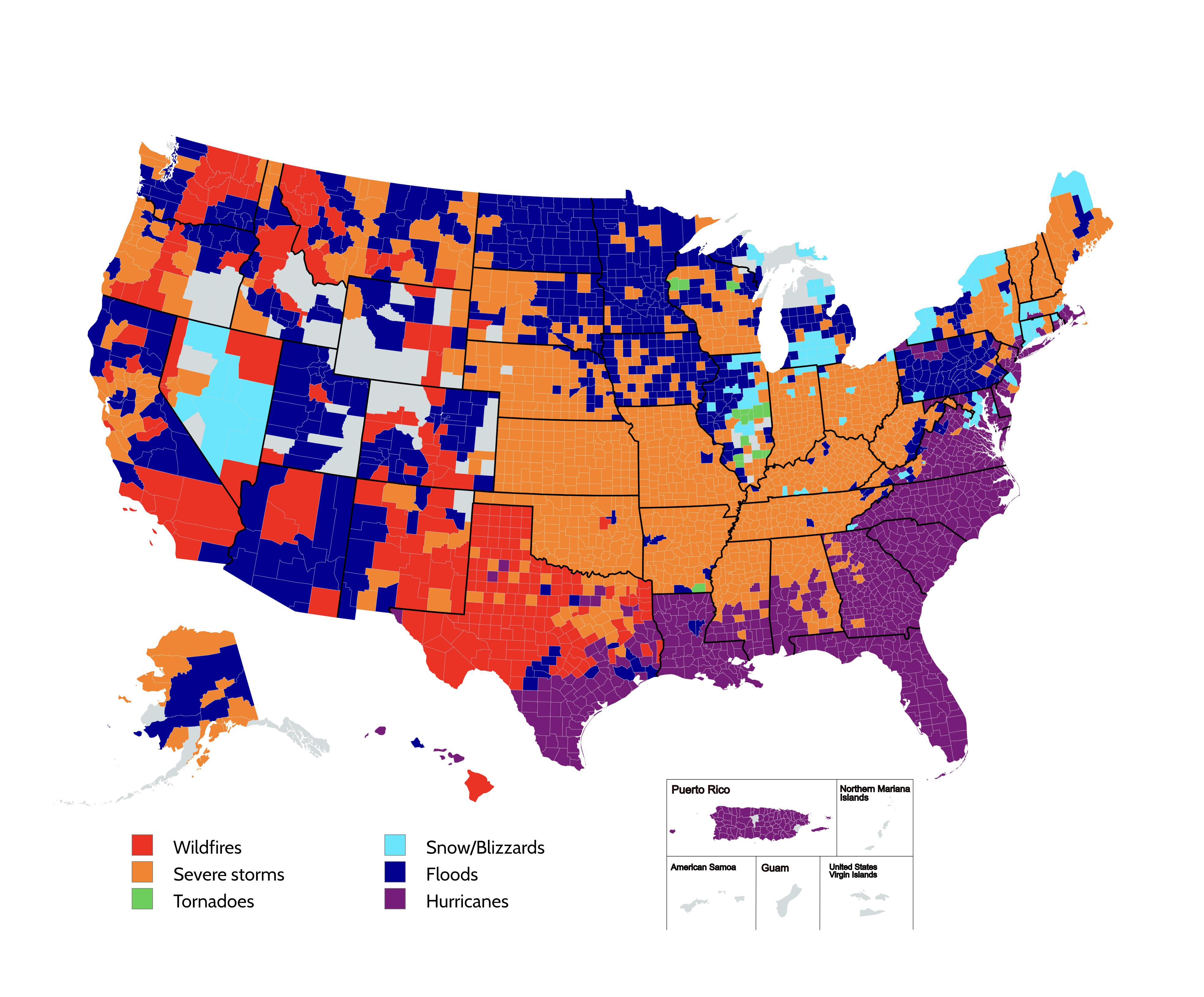
The visualization titled "Most Frequently Occurring Natural Disasters by US County" presents a striking overview of the types of natural disasters that predominantly impact various counties across the United States, based on data collected by the Federal Emergency Management Agency (FEMA) in 2020. Through this map, we can see how different regions are affected by specific natural disasters like hurricanes, tornadoes, floods, and wildfires. Each county is color-coded, reflecting the leading type of disaster that has historically occurred in that area. This information is crucial for understanding not only the geographic distribution of these disasters but also the potential risks and vulnerabilities faced by local communities.
Deep Dive into Natural Disasters in the U.S.
Natural disasters are catastrophic events caused by natural processes of the Earth. They can take many forms, including hurricanes, floods, tornadoes, earthquakes, and wildfires. Understanding the prevalence of these disasters in specific counties is essential for effective emergency planning and mitigation strategies. For instance, hurricanes typically affect the southeastern states, particularly Florida and Louisiana, where coastal counties frequently prepare for hurricane season. On the other hand, tornadoes are most commonly associated with the Great Plains, particularly areas in Kansas and Oklahoma, where conditions are ripe for their formation.
Flooding, a disaster that can occur almost anywhere but is particularly prominent in low-lying regions, has been a significant concern for counties along the Mississippi River and other major waterways. Interestingly, heavy rainfall combined with rapid snowmelt can lead to severe flooding, significantly impacting communities that may not have experienced such disasters before.
Wildfires, fueled by dry conditions and rising temperatures, have become a prevalent concern in western states like California and Colorado. The increase in frequency and severity of wildfires can be attributed to several factors, including climate change, urban development, and changes in land use. In recent years, these fires have not only destroyed homes but also altered ecosystems and affected air quality across vast regions.
While some disasters, like earthquakes, are unpredictable and can happen without warning, others, such as hurricanes and floods, can be anticipated to some extent, allowing communities to prepare. The mapping of these disasters highlights the need for ongoing research and investment in disaster preparedness and response strategies to minimize their impact on human life and infrastructure.
Regional Analysis
Analyzing the map reveals stark contrasts in disaster prevalence across different U.S. regions. For instance, states like Florida and Texas frequently encounter hurricanes, a reflection of their geographical proximity to warm ocean waters and the Gulf of Mexico. In contrast, counties in the Midwest, including parts of Nebraska and Iowa, are often on high alert for tornadoes, particularly during the spring months when conditions are optimal for these severe weather events.
The western U.S. presents a different story, as states like California and Oregon are grappling with increasing wildfire risks. In California, the frequency of wildfires has surged in recent years, prompting state officials to implement stricter building codes and forest management practices. Meanwhile, the Northeast is less prone to these types of disasters but faces its own set of challenges, primarily from flooding due to heavy rainstorms and snowmelt.
Interestingly, while the southeastern U.S. is known for hurricanes, it also faces significant flooding risks, particularly in areas with poor drainage systems. The combination of these two disasters makes it imperative for local governments to develop comprehensive emergency management plans that address the unique threats posed by their specific geographical circumstances.
Significance and Impact
Understanding the frequency and types of natural disasters in various U.S. counties is not just an academic exercise; it has real-world implications for millions of people. Communities must be aware of their vulnerabilities to prepare adequately for potential disasters. This includes developing infrastructure that can withstand extreme weather events, creating emergency response plans, and fostering public education about disaster preparedness.
Moreover, as climate change continues to influence weather patterns, we can expect to see shifts in disaster prevalence. Regions that have historically been safe from certain natural disasters may find themselves increasingly at risk. For example, the rise in global temperatures is contributing to more intense hurricanes and prolonged droughts, which can lead to devastating wildfires in areas previously considered safe.
As we look to the future, it’s crucial for policymakers, urban planners, and community leaders to consider this data when making decisions. The mapping of natural disasters serves as a vital tool for proactive planning and underscores the importance of resilience in the face of an uncertain climate future. By understanding the patterns of past disasters, we can better equip ourselves to face the challenges of tomorrow.
Visualization Details
- Published
- August 8, 2025
- Views
- 126
Comments
Loading comments...