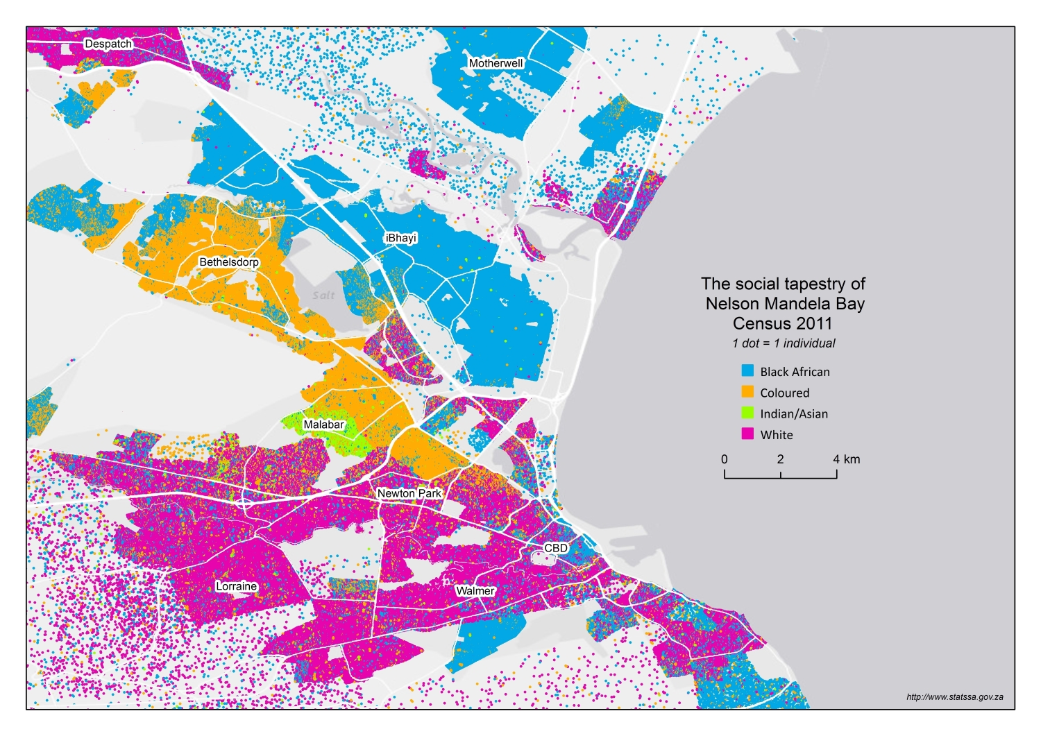
Racial Composition Map of Port Elizabeth

David Chen
Data Visualization Specialist
David Chen is an expert in transforming complex geographic datasets into compelling visual narratives. He combines his background in computer science ...
Geographic Analysis
What This Map Shows\nThe Racial Composition Map of Port Elizabeth (Gqeberha), South Africa, provides a detailed visualization of the demographic distribution of various racial groups within the city. By breaking down the population into distinct categories, this map highlights the complex tapestry of cultural and ethnic identities that make up this coastal city. Port Elizabeth, now officially known as Gqeberha, is not only a hub of economic activity but also serves as a microcosm of South Africa's broader societal dynamics.
Deep Dive into Racial Composition in Port Elizabeth\nUnderstanding the racial composition of Port Elizabeth is crucial for grasping the historical and contemporary context of the region. The city has a diverse population, primarily composed of Black African, Coloured, White, and Indian communities. According to the latest census data, Black Africans constitute around 60% of the population, while Coloured individuals make up approximately 30%. The White population accounts for about 8%, and Indians represent a smaller fraction of less than 2%.
Interestingly, the city's racial demographics echo the complex history of South Africa itself, shaped by colonialism, apartheid, and ongoing socio-economic changes. One striking feature of this map is the significant concentration of Coloured communities in the northern suburbs, which reflects historical settlement patterns influenced by the Group Areas Act during apartheid. This legislation enforced racial segregation, dramatically altering the urban landscape and population distribution.
Have you noticed how certain areas, like the township of Motherwell, show a higher percentage of Black African residents? Such patterns reveal not just historical injustices but also current socio-economic conditions. Motherwell, established as a township during the apartheid era, still struggles with issues like poverty and limited access to services, which are common in many historically marginalized communities.
The White population is predominantly located in the more affluent southern suburbs, such as Summerstrand and Walmer. These areas are characterized by better access to amenities, schools, and job opportunities, highlighting the ongoing disparities that remain rooted in South Africa's divisive past. What's fascinating is how these racial compositions continue to evolve, influenced by migration trends, economic opportunities, and changing social dynamics.
Regional Analysis\nExamining the map closely, we can see distinct regional variations in racial composition. For instance, the northern regions of Port Elizabeth, including areas like New Brighton and Zwide, are predominantly Black African, whereas the southern coastal areas are home to a larger White population. This divide is not merely geographic; it’s laden with historical context that influences social cohesion, economic opportunities, and access to resources.
In contrast, the Coloured population is primarily concentrated in the western parts of the city, reflecting historical settlement patterns. Areas like Schauderville and Korsten are notable for their significant Coloured communities. The differences in racial composition across neighborhoods often correlate with varying levels of infrastructure development, educational attainment, and employment opportunities. For example, while affluent areas boast well-maintained public services, communities in less privileged neighborhoods frequently face challenges such as high unemployment rates and limited access to quality healthcare.
Significance and Impact\nThe racial composition of Port Elizabeth is not just an academic curiosity; it carries real-world implications that affect the lives of its residents. Understanding these demographics is essential for policymakers, urban planners, and community leaders who are tasked with addressing inequality and fostering social cohesion. The legacy of apartheid still looms over the city, influencing everything from housing policies to educational initiatives.
Current trends indicate that as South Africa grapples with its economic challenges, the racial composition of cities like Port Elizabeth will continue to evolve. Increased migration from rural areas to urban centers could lead to shifts in demographic patterns, potentially exacerbating existing tensions or fostering greater integration.
In conclusion, the Racial Composition Map of Port Elizabeth serves as a vital tool for understanding the city's sociocultural landscape. It illustrates not only where people live but also the historical narratives and present realities that shape their everyday lives. By delving into these demographics, we can uncover the layers of complexity that define Port Elizabeth, a city marked by resilience and a quest for equity in a post-apartheid South Africa.
Visualization Details
- Published
- August 8, 2025
- Views
- 182
Comments
Loading comments...