Political Map of Europe 1240 AD

Marcus Rodriguez
Historical Geography Expert
Marcus Rodriguez specializes in historical cartography and geographic data analysis. With a background in both history and geography, he brings unique...
Geographic Analysis
What This Map Shows
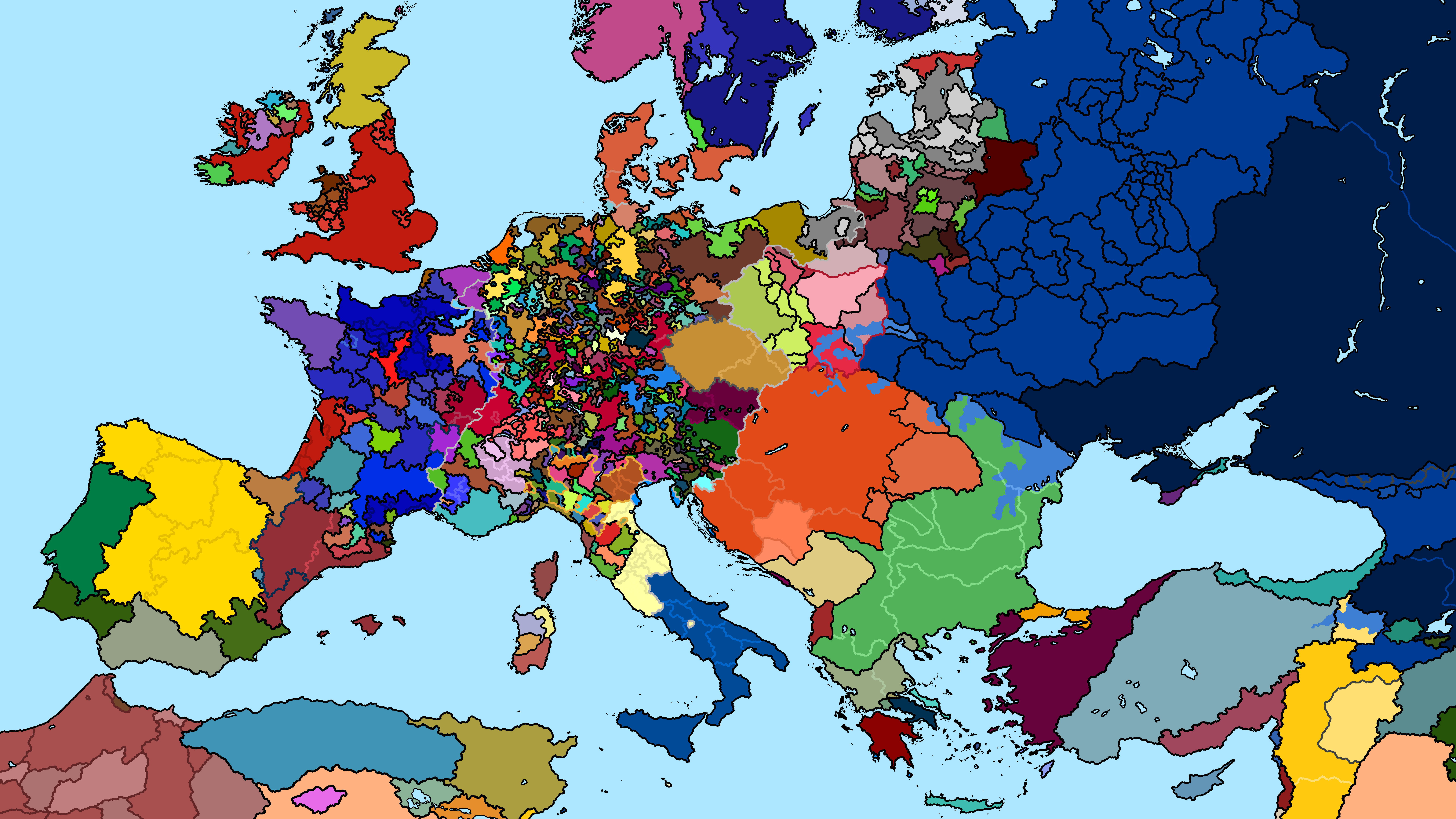
The "Map of Europe 1240 AD" presents a snapshot of the political landscape in medieval Europe. During this time, the continent was a patchwork of kingdoms, principalities, and territories, each vying for power and influence. The map highlights the various feudal states, their borders, and the significant regions that were emerging as centers of power. It serves as a crucial historical document, providing a glimpse into the political dynamics of the time.
Deep Dive into the Political Landscape of 1240 AD
In 1240 AD, Europe was in the midst of the Middle Ages, a period marked by feudalism, territorial conflicts, and the gradual rise of centralized monarchies. The political structure was predominantly feudal, meaning that land was owned by lords who granted portions to vassals in exchange for military service. This feudal system created a complex web of allegiances and conflicts, shaping the political landscape of the continent.
Interestingly, this period saw the emergence of several significant kingdoms. The Kingdom of France was evolving into a powerful monarchy under the rule of King Louis IX, also known as Saint Louis. Meanwhile, in the east, the Holy Roman Empire was a significant entity, comprising numerous semi-autonomous states and principalities. The emperor had limited control over these regions, which often acted independently, leading to a fragmented political structure.
In the British Isles, England was experiencing its own political turmoil. The reign of King Henry III was marked by internal strife, including conflicts with barons and the eventual rise of the baronial movement, which sought to limit the power of the monarchy. On the other hand, Scotland was asserting its identity, with figures like William Wallace emerging in the subsequent century to challenge English dominance.
Meanwhile, in the Iberian Peninsula, the Reconquista was well underway, with Christian kingdoms like Castile and Aragon gradually reclaiming territories from Muslim rule. This struggle not only shaped the political map but also had lasting cultural and religious implications for the region.
In the east, the Mongol invasions were beginning to have a profound impact on Eastern Europe, with the establishment of the Golden Horde affecting the political dynamics of the region. The influence of the Mongols would lead to significant changes in governance, trade, and military strategies across Europe.
Regional Analysis
When analyzing the various regions displayed on the map, distinct differences in political organization and stability become apparent. For instance, Western Europe, particularly France and England, was characterized by stronger centralized authorities, despite internal conflicts. France, under Louis IX, began to consolidate power effectively, while England grappled with baronial dissent.
In contrast, Central and Eastern Europe were more fragmented. The Holy Roman Empire, for instance, consisted of numerous semi-independent states, each with its own ruler and set of loyalties. This led to a lack of cohesion, making it vulnerable to external threats, such as the Mongol invasions.
The Iberian Peninsula presented a unique case, where the coexistence of Muslim and Christian kingdoms created a complex tapestry of alliances and rivalries. The ongoing Reconquista not only reshaped borders but also influenced cultural exchanges between the two religious groups.
What's fascinating is how these regional differences laid the groundwork for future state formations and conflicts. For example, the political instability in England during this time would eventually contribute to the emergence of the Magna Carta and the development of parliamentary democracy.
Significance and Impact
Understanding the political map of Europe in 1240 AD is crucial for contextualizing the historical forces that shaped modern European nations. The feudal system, territorial conflicts, and the shifting balance of power between kingdoms during this period set the stage for significant developments in governance, culture, and society.
Today, when we look back at this era, we can see that the roots of many contemporary political boundaries and national identities trace back to the events and power struggles of the Middle Ages. As global geopolitics continues to evolve, recognizing the historical context behind these changes helps us appreciate the complexities of modern nation-states.
Moreover, the lessons learned from this period, particularly regarding the balance of power, governance, and the importance of alliances, remain relevant today. As nations navigate their relationships with one another in an increasingly interconnected world, the political dynamics of 1240 AD serve as a reminder of the enduring nature of human political behavior.
In conclusion, the "Map of Europe 1240 AD" is more than just a historical artifact; it is a window into the past that helps us understand the present and anticipate the future of European politics.
Visualization Details
- Published
- August 7, 2025
- Views
- 108
Comments
Loading comments...