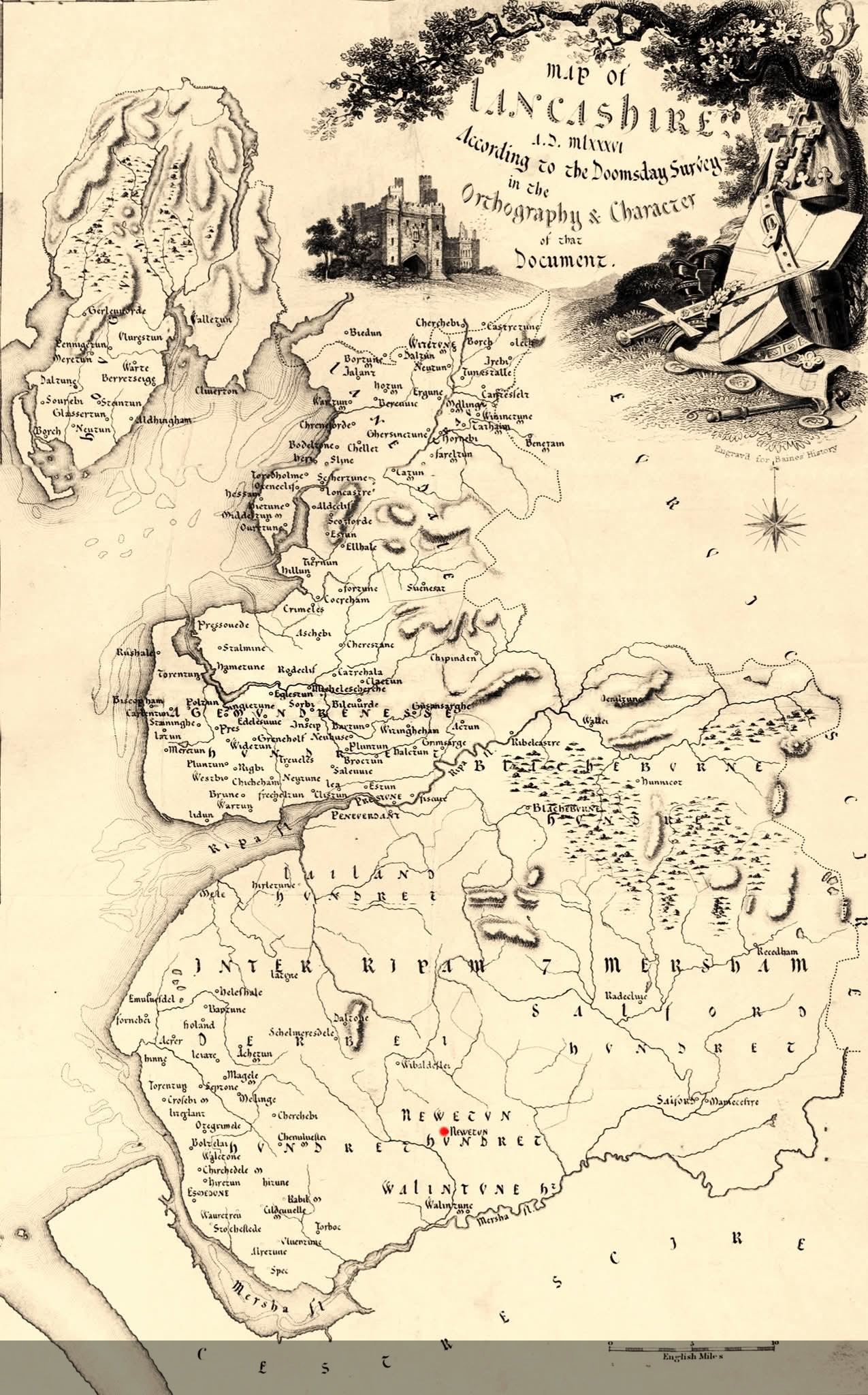
Map of Lancashire, England, from the 1086 Domesday Survey

David Chen
Data Visualization Specialist
David Chen is an expert in transforming complex geographic datasets into compelling visual narratives. He combines his background in computer science ...
Geographic Analysis
What This Map Shows
The "Map of Lancashire, England, according to the 1086 Domesday Survey" presents a fascinating glimpse into the socio-economic landscape of medieval England. This historical document, commissioned by William the Conqueror, aimed to assess the wealth and resources of his newly acquired territories. The map highlights various settlements, land ownership, and agricultural practices that shaped Lancashire during this pivotal time in history.
However, the significance of the Domesday Survey extends beyond mere land ownership; it illustrates the distribution of power and resources in post-Conquest England. With this understanding, we can dive deeper into the implications of the map and the historical context it provides.
Deep Dive into the Domesday Survey and Lancashire
The Domesday Survey represents one of the earliest comprehensive records of land and resource distribution in England. Conducted in 1086, it categorized landholdings, the number of inhabitants, and the productivity of various regions. Lancashire, at that time, was a relatively undeveloped area compared to other parts of England, such as Kent or Wessex.
Interestingly, the Domesday records indicate that Lancashire was home to a variety of settlements, including towns, villages, and farms. Notably, places like Lancaster and Preston emerged as significant centers of trade and administration. The survey detailed the land’s agricultural potential, with entries noting the types of crops cultivated and the number of livestock owned. For instance, it recorded that the region was particularly favorable for sheep farming, which was crucial for wool production—a booming industry in medieval England.
Moreover, the map reveals the feudal system in action. Land was primarily owned by the king and distributed to loyal nobles, who in turn managed the land and its resources. This hierarchical structure is evident in the map, where landownership can be traced to various lords and their holdings. The relationship between land use and social status becomes clear; those controlling more land held greater power and influence in the region.
The Domesday Survey also sheds light on the population distribution. Although specific numbers are elusive, the map suggests that Lancashire had a relatively small population during this era. The majority of inhabitants were likely engaged in agriculture, with a significant portion of the population living in rural areas. Understanding the demographic layout of the time provides insight into the social dynamics that existed, including the reliance on serfs and peasants for labor.
Regional Analysis
Examining the Domesday map of Lancashire reveals regional disparities in wealth and land management. For example, the area around Lancaster was one of the most prosperous, benefiting from its strategic position along the River Lune. This waterway not only provided a means of transportation but also contributed to the fertility of the surrounding lands. In contrast, areas further inland, such as the Forest of Bowland, were less developed and primarily utilized for hunting and timber production.
Furthermore, the map illustrates how certain regions were more resilient to the socio-economic challenges of the time. Coastal areas had access to trade routes, which facilitated commerce and economic growth. In contrast, isolated regions faced difficulties in accessing markets, leading to a dependence on subsistence farming. This variation in economic activity and land use highlights the diverse experiences of communities within Lancashire during the 11th century.
Significance and Impact
The significance of the Domesday Survey and its depiction of Lancashire cannot be overstated. This historical document laid the groundwork for future land management and governance in England. By documenting landholdings and resources, it provided a framework for taxation and feudal obligations that persisted for centuries.
Additionally, the insights gleaned from this map can inform current studies of land use and development in Lancashire. Understanding the historical context of land distribution helps us comprehend contemporary issues such as urbanization, agricultural practices, and even regional identity. Interestingly, many of the settlements noted in the Domesday Survey have evolved into modern towns and cities, reflecting a continuous thread of human habitation and adaptation.
As we look ahead, the implications of this historical mapping extend into discussions about sustainability and land management today. With increasing pressures from urban development and climate change, understanding the historical context of land use in regions like Lancashire can guide future planning efforts to balance heritage preservation with modernization. Ever wondered how a thousand-year-old land survey could influence today's geographic and socio-economic discussions? The answer lies in the enduring legacy of the Domesday Survey, which continues to shape our understanding of land and society.
Visualization Details
- Published
- August 6, 2025
- Views
- 94
Comments
Loading comments...