Largest Freeway Systems in 2025 Map

Alex Cartwright
Senior Cartographer & GIS Specialist
Alex Cartwright is a renowned cartographer and geographic information systems specialist with over 15 years of experience in spatial analysis and data...
Geographic Analysis
What This Map Shows
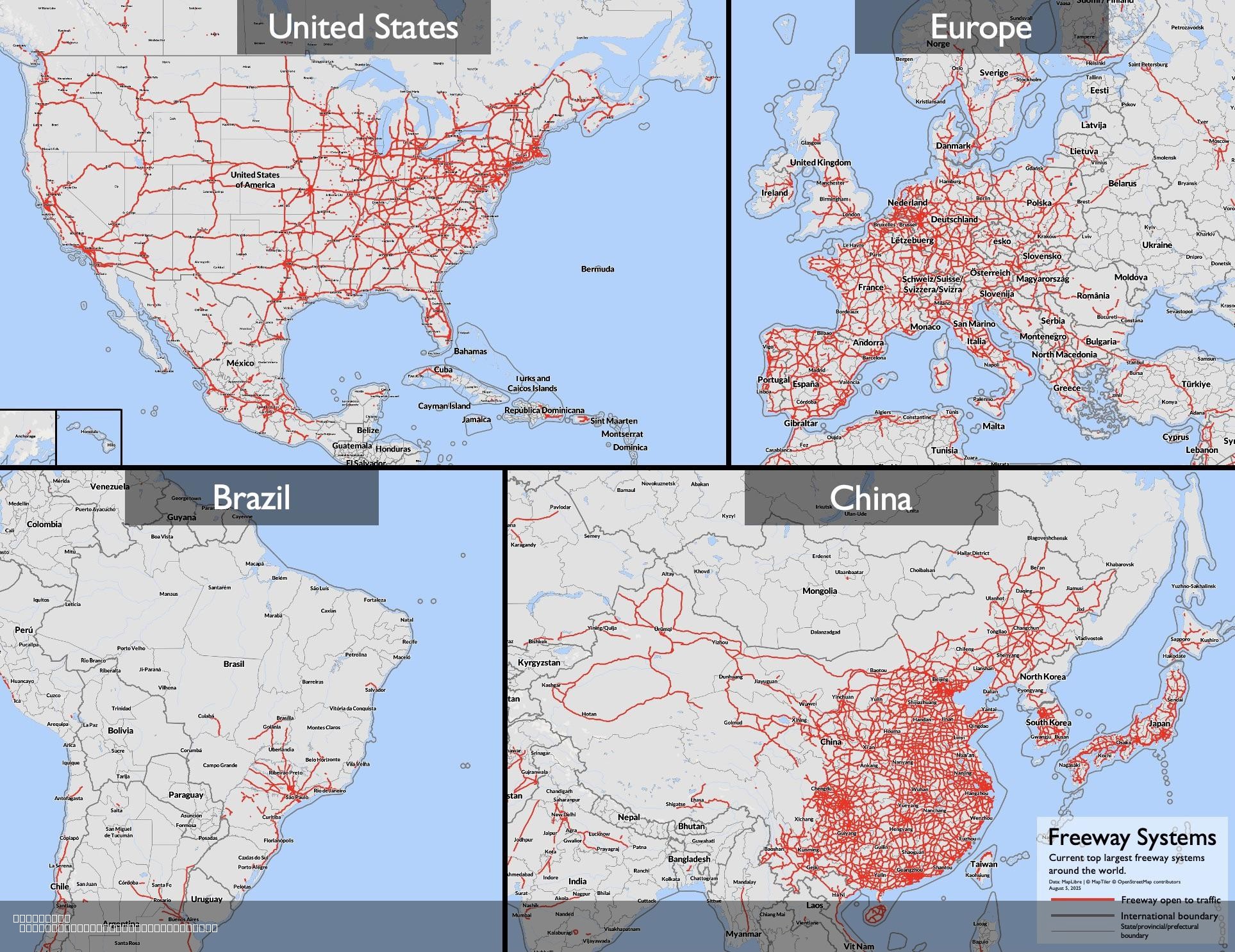
The "Largest Freeway Systems in 2025 Map" provides a comprehensive visualization of major freeway networks across the globe, highlighting the expansive and complex systems that facilitate vehicular movement in urban and suburban areas. This updated map reflects additional freeways that were previously missing, ensuring a more accurate portrayal of the world's busiest freeway systems. As we delve deeper into the topic of freeway systems, we can better understand their role in transportation, urban development, and economic growth.
Deep Dive into Freeway Systems
Freeway systems are vital arteries for modern transportation, designed to accommodate high volumes of traffic while minimizing interruptions. These limited-access highways not only facilitate long-distance travel but also connect cities and regions, serving as critical components of national and international trade networks. The characteristics of freeway systems vary significantly based on geography, population density, and regional development.
The United States boasts one of the largest freeway networks in the world, with over 47,000 miles of interstate highways. These freeways were designed in the mid-20th century, reflecting a post-war boom in automobile ownership and suburbanization. What’s fascinating is that the U.S. interstate system not only connects major urban centers but also plays a significant role in the nation’s economy, enabling the efficient movement of goods and services.
Interestingly, other countries have developed extensive freeway systems as well. For instance, China's freeway network has expanded rapidly over the past few decades, now stretching over 77,000 miles. This growth corresponds with China's urbanization and economic reform, dramatically reshaping the landscape of transportation in the country. The rapid construction of these freeways has facilitated the movement of millions of people and goods across vast distances, impacting regional economies.
In Europe, freeway systems are also noteworthy, with countries like Germany and France leading the way. Germany’s Autobahn is famous for its stretches without speed limits, showcasing a unique approach to speed and efficiency in road design. Meanwhile, France's extensive autoroute network connects major cities and facilitates trade across borders, reflecting the importance of freeways in European integration and cooperation.
Freeway systems are not just about connectivity; they also reflect societal trends. For instance, urban sprawl has led to an increased dependency on personal vehicles, with many cities designed around freeway access. This has implications for urban planning, public health, and the environment. Increased freeway access often correlates with higher rates of car ownership, leading to traffic congestion, air pollution, and urban heat islands. Understanding these dynamics is crucial for addressing the challenges presented by urbanization.
Regional Analysis
When analyzing the map of the largest freeway systems, we notice distinct patterns based on geography and economic development. The United States, with its extensive highway network, stands in contrast to smaller countries with shorter freeway systems. For example, in comparison to the U.S. and China, countries in Africa have limited freeway infrastructure, which significantly impacts trade and mobility. In South Africa, the N1 freeway connects several major cities but still lacks the extensive coverage seen in more developed regions.
In Asia, Japan's expressway system exemplifies a different approach. The country's mountainous terrain has led to innovative engineering solutions, including tunnels and bridges, to ensure connectivity. The expressway network not only supports domestic travel but also plays a role in disaster recovery, providing critical routes during emergencies.
Furthermore, in Latin America, Brazil’s freeway systems, such as the BR-101, are essential for linking the vast country’s regions. However, these systems often face challenges related to maintenance and funding, leading to disparities in roadway quality and safety.
Significance and Impact
The significance of freeway systems extends beyond mere transportation; they influence economic development, urban planning, and environmental sustainability. As urban areas continue to grow, the demand for efficient transportation networks becomes increasingly critical. Freeways shape the way cities expand, affecting where people live, work, and how they interact with their environment.
Moreover, the rise of electric vehicles and autonomous driving technology presents new challenges and opportunities for freeway systems. Planning for these innovations requires a reevaluation of existing infrastructures to accommodate changing transportation paradigms. As we look to the future, understanding the evolution of freeway systems will be essential in addressing issues like congestion, pollution, and climate change.
In conclusion, the "Largest Freeway Systems in 2025 Map" is not just a representation of roads; it is a reflection of our societal choices, economic priorities, and the intricate relationships between geography and infrastructure. As we continue to navigate the complexities of transportation, this map serves as a vital tool for understanding the past, present, and future of freeway systems around the globe.
Visualization Details
- Published
- August 5, 2025
- Views
- 120
Comments
Loading comments...