Administrative Divisions of Democratic Republic of Georgia Map

Marcus Rodriguez
Historical Geography Expert
Marcus Rodriguez specializes in historical cartography and geographic data analysis. With a background in both history and geography, he brings unique...
Geographic Analysis
What This Map Shows
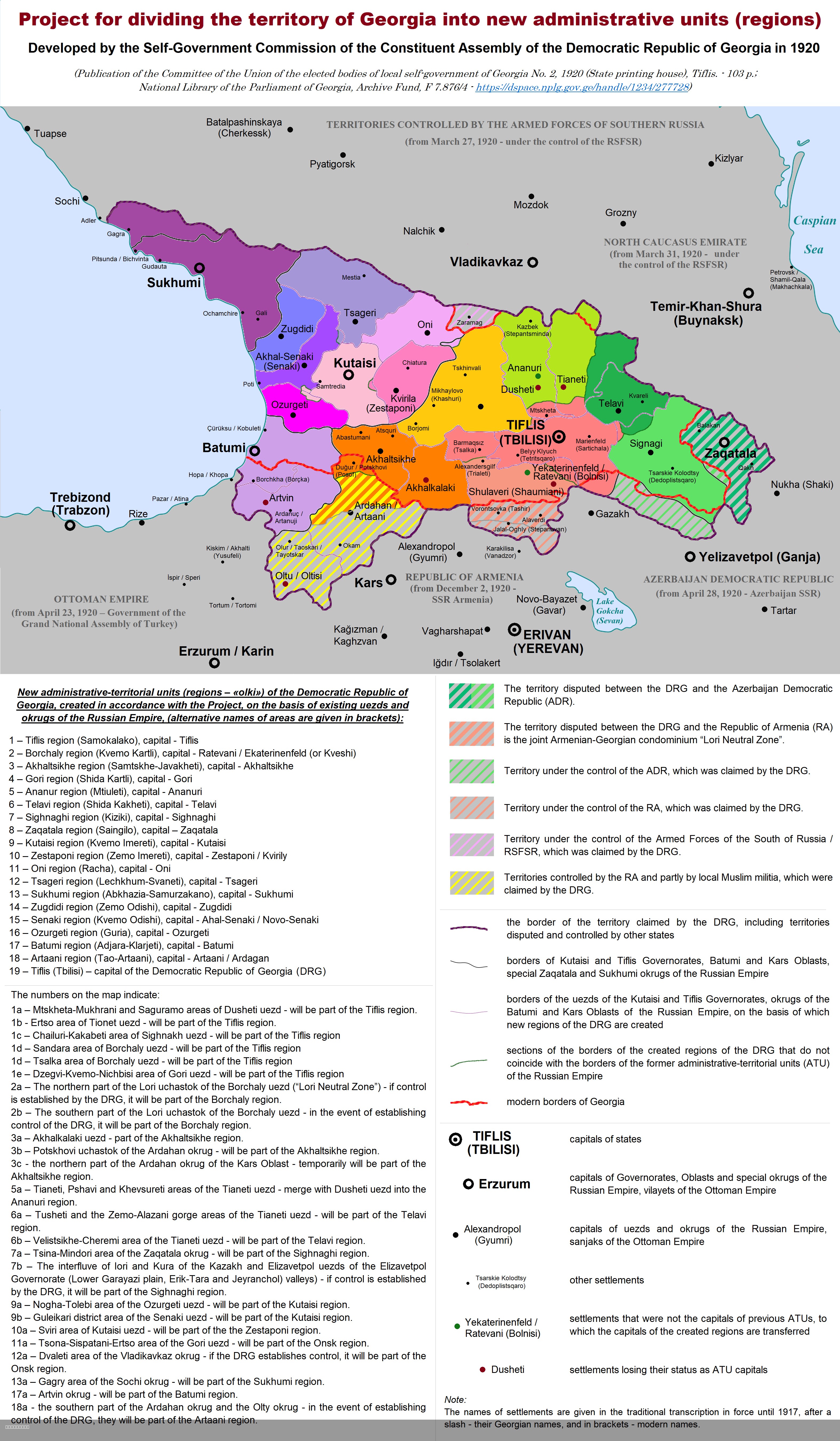
This map illustrates the division of the territory of the Democratic Republic of Georgia (DRG) into new administrative units following a 1920 project. The visual representation not only details the administrative boundaries that were proposed at that time but also serves as a historical document reflecting the geopolitical aspirations and challenges faced by Georgia in the early 20th century. Interestingly, this restructuring came just before a tumultuous period in the nation’s history, as the very next year, the DRG faced invasion and occupation by the Red Army.
Deep Dive into Administrative Divisions
Administrative divisions are crucial for governance, resource distribution, and local representation. They often reflect the historical, cultural, and demographic nuances of a region. In the case of the Democratic Republic of Georgia, the push for new administrative units in 1920 was an attempt to create a more efficient local government system that could respond to the needs of a diverse population.
The DRG was characterized by a mix of ethnic groups, including Georgians, Armenians, and Azerbaijanis, each with distinct cultural identities. The administrative divisions proposed in 1920 aimed to accommodate these differences, potentially creating units that aligned more closely with ethnic and social demographics. This was particularly important in a region that had seen significant political shifts and ethnic tensions over the years.
Interestingly, the number and boundaries of these proposed units were not just a reflection of demographic considerations but also of strategic military and political interests. The mapping of these divisions was likely influenced by the need for effective governance, especially in light of the surrounding geopolitical instability. After the Russian Revolution, many regions, including Georgia, were in flux, grappling with the ramifications of changing political powers.
As we look at the historical context, it’s important to note that Georgia declared independence in 1918, following the collapse of the Russian Empire. The DRG was established with hopes of creating a stable and independent state. Therefore, the 1920 administrative restructuring can be seen as part of a broader effort to consolidate power and establish a cohesive national identity amidst external pressures.
Regional Analysis
Examining the proposed administrative divisions reveals patterns in regional governance that echo the historical complexities of the DRG. For instance, the focus on creating distinct administrative units in areas with strong ethnic identities suggests an understanding of the need for localized governance that could better address community needs.
Interestingly, the proposed divisions may have varied significantly in terms of population density and economic activity. Urban areas like Tbilisi, the capital, would likely have required different administrative considerations compared to more rural regions. This variation emphasizes the importance of tailoring governance to the specific characteristics and needs of different areas. Furthermore, looking at the interactions between these units, one might wonder about the potential for conflict or cooperation among neighboring administrative divisions, especially given their diverse populations.
The administrative map also indicates potential resource allocation patterns. By understanding the geographical distribution of resources like water, agricultural land, and industrial centers, we can infer how the DRG might have prioritized economic development in certain regions over others.
Significance and Impact
The significance of understanding the administrative divisions of the Democratic Republic of Georgia in 1920 lies not only in its historical context but also in its implications for contemporary geopolitical discussions. The DRG's experience serves as a case study in how administrative boundaries can influence national identity, governance effectiveness, and inter-ethnic relations.
Interestingly, the aftermath of the administrative restructuring was overshadowed by the Red Army's invasion in 1921, leading to a Soviet takeover. This highlights how fragile state structures can be in politically volatile regions. In today’s context, as countries grapple with their own administrative challenges, the lessons learned from the DRG’s experience remind us of the importance of inclusive governance that recognizes and respects ethnic diversity.
Moreover, current trends in administrative governance often lean towards decentralization, allowing for greater local autonomy. This move is particularly relevant for countries with diverse populations, as it can facilitate better representation and resource management. As regions around the world reassess their administrative boundaries, the historical example of the DRG may provide valuable insights into the complexities of governance and the need for adaptive strategies in addressing both historical grievances and contemporary challenges.
In conclusion, the map of administrative divisions in the Democratic Republic of Georgia serves as more than just a historical artifact; it is a reflection of the intersection between governance, identity, and the ever-evolving landscape of political power. Understanding these dynamics can enhance our appreciation for the intricate tapestry of human geography that shapes our world today.
Visualization Details
- Published
- August 4, 2025
- Views
- 138
Comments
Loading comments...