Topographic Map of North America

Marcus Rodriguez
Historical Geography Expert
Marcus Rodriguez specializes in historical cartography and geographic data analysis. With a background in both history and geography, he brings unique...
Geographic Analysis
What This Map Shows
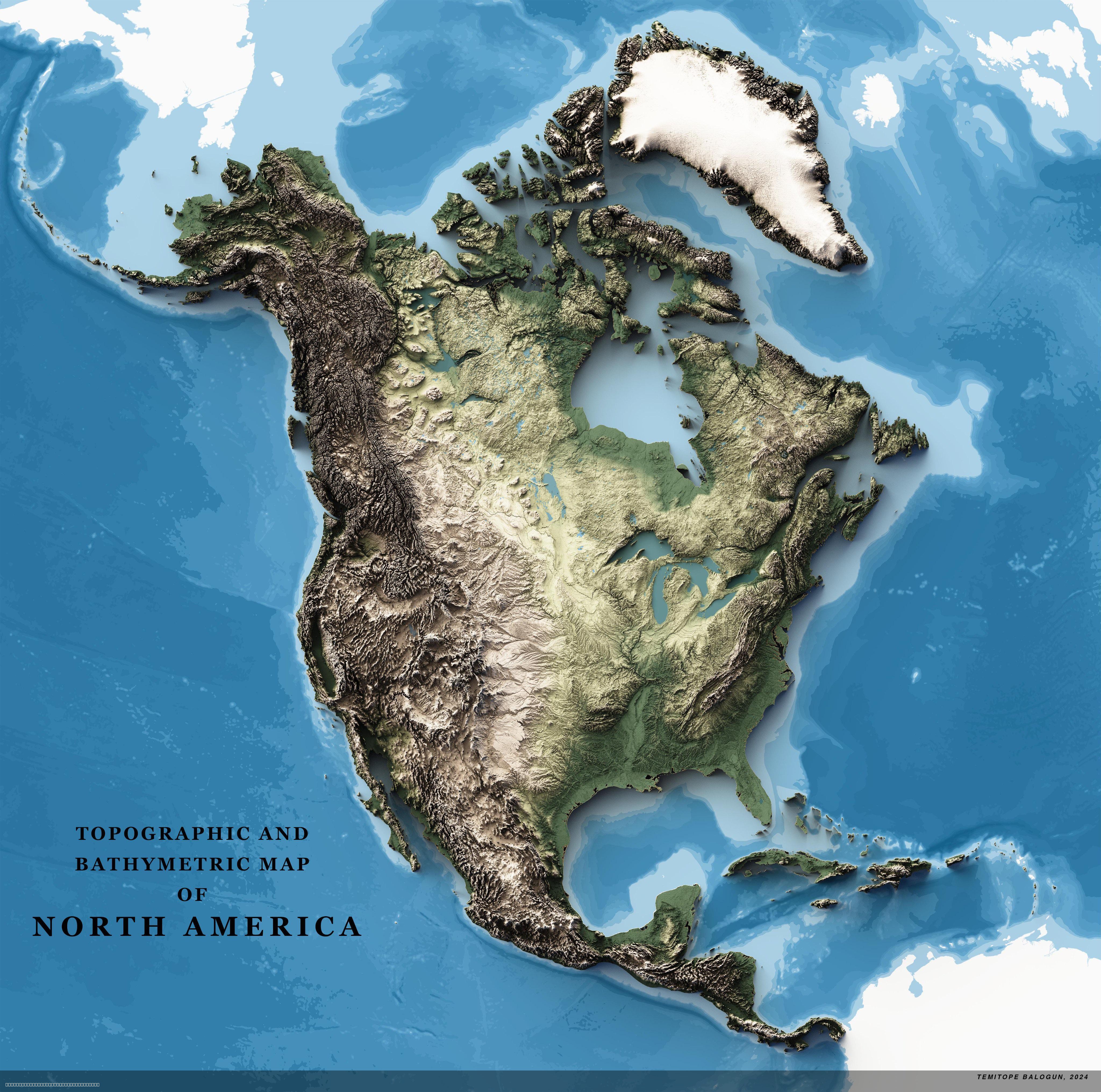
The 4K Topographic Map of North America provides a stunningly detailed view of the continent's diverse terrain, showcasing everything from majestic mountain ranges to sprawling plains and intricate coastlines. This map employs a rich color palette and intricate shading to represent elevation changes, with higher altitudes depicted in vibrant hues while lower areas are illustrated in softer tones. It serves as a tool for understanding the physical geography of North America, highlighting the geological features that shape the continent's landscapes.
Transitioning from the visualization itself, let’s delve into the topic of North America's topography, which is a fascinating interplay of geological processes, climate influences, and ecological diversity.
Deep Dive into North America's Topography
North America is characterized by a variety of landforms that define its geography. The continent is divided into several major geographical regions: the Rocky Mountains, the Appalachian Mountains, the Great Plains, and the coastal plains, among others. Each of these regions has its own distinct features influenced by tectonic activity, erosion, and climate.
The Rocky Mountains, stretching from Canada to New Mexico, are one of the most recognizable features of North America's topography. These rugged mountains rise dramatically, with peaks that often exceed 14,000 feet. Interestingly, the Rockies are still growing due to ongoing tectonic activity. Along their slopes, you'll find a variety of ecosystems ranging from alpine tundra at higher elevations to dense forests at lower levels.
In contrast, the Appalachian Mountains, which are much older and more eroded, provide a different landscape. Running from Newfoundland in Canada down to Alabama in the United States, the Appalachians are characterized by rolling hills and valleys. The elevation here rarely exceeds 6,000 feet, but the range is rich in biodiversity, housing numerous species of flora and fauna that depend on its unique microclimates.
Moving to the interior of the continent, the Great Plains dominate a significant portion of North America. Known for their vast expanses of flat land, these plains are crucial for agriculture and have been dubbed the "breadbasket" of the continent. Composed primarily of fertile soil, the Great Plains have a relatively low elevation but are subject to various climatic conditions, including tornadoes and droughts, which can significantly impact farming practices.
Additionally, the coastal areas of North America present a unique topographical aspect. The Pacific Coast features rugged cliffs and deep fjords, while the Atlantic Coast is characterized by sandy beaches and barrier islands. The Gulf Coast, with its marshes and wetlands, plays a crucial role in biodiversity and acts as a buffer against storms.
Regional Analysis
When examining North America by regions, stark contrasts in topography become apparent. For instance, the western region, dominated by the Rocky Mountains, experiences a much different climate than the eastern region, where the Appalachian Mountains prevail. The Rockies, with their elevation, have a much colder climate, while the Appalachians benefit from warmer temperatures conducive to agriculture.
In the Midwest, the flat landscapes of the Great Plains differ dramatically from the mountainous terrains of the West. This region is essential for grain production, contributing significantly to the U.S. economy. Interestingly, the shift from the plains to the foothills of the Rockies can be seen in the transition from agricultural land to more rugged terrain, showcasing how topography influences land use.
Looking at the coastal regions, the Pacific Northwest's rugged coastline contrasts sharply with the smooth sandy beaches of the Southeast. This difference affects not only the local climate but also the types of ecosystems present. For example, the temperate rainforest of the Pacific Northwest supports diverse species, while the subtropical climate of the Gulf Coast fosters a different set of flora and fauna.
Significance and Impact
Understanding the topography of North America is vital for several reasons. Not only does it influence local climates and ecosystems, but it also plays a critical role in human activities, such as agriculture, urban development, and resource extraction. For instance, the fertile soils of the Great Plains have made it a hub for agricultural production, while the mineral-rich Rocky Mountains have facilitated mining operations.
Moreover, as climate change continues to impact weather patterns, the topography of North America becomes even more significant. With rising sea levels, coastal areas are at greater risk, and understanding the geography can inform urban planning and disaster preparedness. Additionally, as natural disasters such as wildfires and floods become more frequent, knowing the topographical variations can help in developing effective response strategies.
In conclusion, the 4K Topographic Map of North America not only serves as a beautiful visualization of the continent’s physical features but also highlights the complex interactions between geography and the environment. The interplay of mountains, plains, and coastlines shapes not only the landscape but also the lives of the people who inhabit this vast and diverse continent.
Visualization Details
- Published
- August 3, 2025
- Views
- 152
Comments
Loading comments...