1515 World Map of the New World

David Chen
Data Visualization Specialist
David Chen is an expert in transforming complex geographic datasets into compelling visual narratives. He combines his background in computer science ...
Geographic Analysis
What This Map Shows
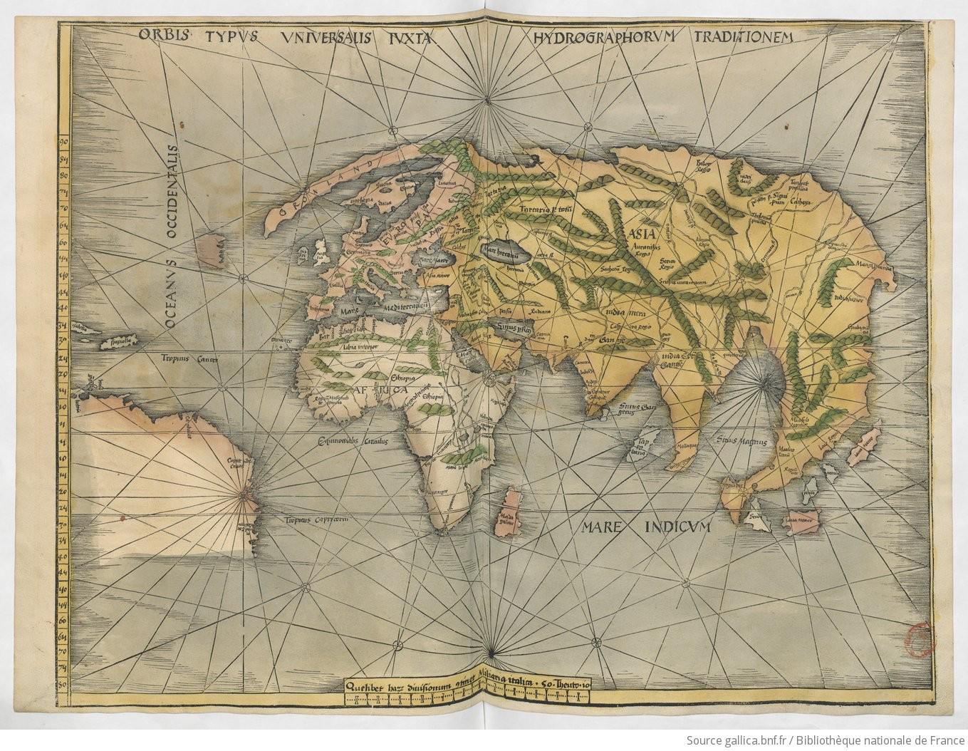
The 1515 world map, titled *Orbis Typus Universalis iuxta Hydrographorum Traditionem*, is a fascinating representation created by Martin Waldseemüller and Matthias Ringmann. This map showcases not only Europe, Africa, and Asia but also presents a fragmented view of the New World, which intriguingly isn't referred to as 'America' yet. The map provides a unique glimpse into the geographical knowledge of the time, illustrating how the understanding of the world was rapidly evolving, particularly in light of recent discoveries. However, it does not encompass the entire globe; it halts at the Antilles in the west and barely extends into eastern Asia, leaving the Pacific Ocean almost entirely absent. This lack of completeness speaks volumes about the limited maritime exploration that had occurred up to that point.
Deep Dive into the New World
The New World, as depicted on this map, offers a tantalizing look at early European perceptions of the Americas. Notably, Greenland is illustrated as a peninsula of Europe, a geographical misconception that persisted for centuries. The Caribbean is simplified to only three islands: Isabella (Cuba), Jamaica (unnamed), and Spagnola (Hispaniola). This limited representation reflects the early stages of European exploration and colonization, highlighting the gaps in knowledge that still existed.
Interestingly, the coast of South America appears truncated, stopping near the Gulf of Venezuela. The islands named Giga and Brasil, along with inscriptions like Canibiles and Alta pago de S. paulo, indicate a nascent understanding of the continent but also suggest the cartographers' reliance on hearsay rather than firsthand exploration. The descriptions and names used on the map highlight the blend of myth and reality that characterized early cartography.
As we delve deeper into the specifics, it’s vital to note how the map integrates Portuguese discoveries, especially in Asia, which are represented accurately with India and Sri Lanka. However, it still clings to aspects of Ptolemaic geography, such as the phantom peninsula southeast of Asia. This remnant emphasizes the transitional phase of cartographic evolution, where new information was slowly being absorbed into existing frameworks.
Regional Analysis
Examining the regions depicted in the 1515 map reveals intriguing contrasts and developments. In Europe, the map aligns closely with contemporary knowledge, showcasing familiar territories and their political boundaries. Moving towards Africa, the representation reflects both the known and the unknown, with regions such as the Sahara being largely detailed while others remain vague and undefined.
In the Americas, the Caribbean islands are prominent but limited. The absence of names for other islands suggests either a lack of exploration or a conscious choice to focus on the more prominent territories. The South American coast, as mentioned, is notably incomplete, which may indicate the limitations of early explorers in mapping the continent's extensive coastline.
Interestingly, the map does not connect Asia and America, which reflects a still-embryonic understanding of global geography. The separation suggests that the cartographers were unaware of the vast Pacific Ocean that lay between these two landmasses, a crucial oversight that would later be rectified as exploration expanded.
Significance and Impact
The significance of this map extends beyond its immediate geographical representation. It serves as a historical document that encapsulates the transitional nature of early 16th-century cartography. The map's limitations illustrate the gaps in knowledge that explorers faced during this era of discovery. As maritime exploration continued to evolve, the representation of the New World would undergo substantial changes, leading to a more interconnected view of the globe.
Today, understanding these historical maps is essential for grasping how geographical knowledge has transformed. The evolution from this fragmented world view to our current, more comprehensive understanding highlights not only advancements in exploration but also the cultural and political implications of these discoveries. As we consider the trajectory of cartography, it’s fascinating to think about how future maps will continue to reflect our understanding of the world, potentially revealing new continents or features yet unknown to us. The 1515 world map, therefore, stands as a testament to a pivotal moment in history, capturing the essence of a world on the brink of discovery.
Visualization Details
- Published
- October 27, 2025
- Views
- 8
Comments
Loading comments...