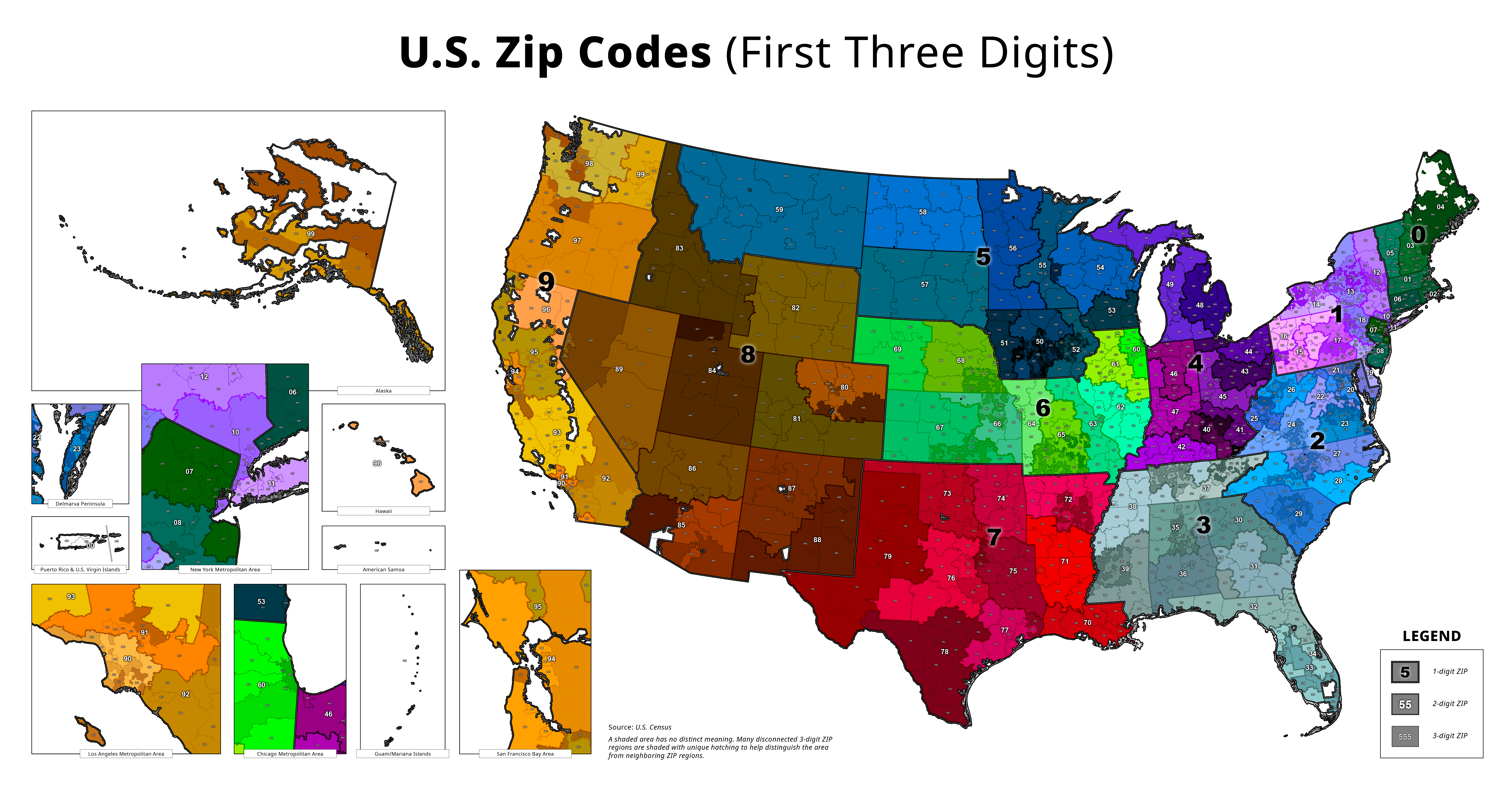
Map of America's Zip Codes


Alex Cartwright
Senior Cartographer & GIS Specialist
Alex Cartwright is a renowned cartographer and geographic information systems specialist with over 15 years of experience in spatial analysis and data...
Geographic Analysis
What This Map Shows
The "Map of America's Zip Codes" provides a comprehensive visualization of the postal code system across the United States. Each zip code area is delineated, showcasing the geographic distribution and boundaries of these codes that play a crucial role in mail delivery, demographic analysis, and even marketing strategies. This map serves as a crucial tool for understanding not just where people live, but also how they are connected across the vast expanse of the country.
Deep Dive into Zip Codes
Zip codes, introduced in the U.S. in 1963, are more than just a series of numbers; they provide insight into the demographic and economic landscape of an area. Each zip code corresponds to a specific region, often encompassing neighborhoods or communities, and helps to streamline the mailing process. However, their significance extends far beyond simple logistics.
Interestingly, zip codes can reveal a wealth of information about the characteristics of the residents within that area. For instance, urban zip codes tend to have higher population densities, diverse demographics, and a range of socioeconomic statuses. In contrast, rural zip codes might cover larger land areas with lower population counts, often reflecting agricultural or undeveloped regions.
In terms of demographics, areas with similar zip codes often share characteristics such as income levels, education attainment, and even health outcomes. For example, the zip code 10001 in New York City is known for its vibrant culture and high cost of living, contrasting sharply with the more suburban zip code 12345 in Schenectady, NY, which has a very different economic profile.
A fascinating aspect of zip codes is how they can influence marketing strategies for businesses. Companies often target their advertisements based on the zip code demographics, ensuring that their messages resonate with the specific audiences they want to attract. As a result, understanding the layout of zip codes is vital for effective business operations and urban planning.
Regional Analysis
When breaking down the nation by regions as shown on the map, one can observe significant variations in zip code distribution. For instance, the densely populated Northeast, including states like New York and New Jersey, has a complex web of zip codes reflecting its urbanized nature. This region often showcases high-income areas alongside economically challenged neighborhoods, highlighting stark contrasts in living conditions.
On the other hand, the Midwest presents a different picture. States like Nebraska and Iowa have vast stretches of rural zip codes, often indicating agricultural communities with lower population densities. However, cities such as Chicago in Illinois show a concentration of diverse zip codes, each representing unique cultural and economic hubs.
In the South, zip codes often reflect historical patterns of migration and economic development. For example, areas around Atlanta, Georgia, have seen rapid growth and diversification of zip codes in recent years, while rural areas in Mississippi may still reflect older demographic trends. The West Coast, particularly California, showcases zip codes that range dramatically from affluent neighborhoods in Beverly Hills to less affluent regions in parts of Los Angeles.
Significance and Impact
Understanding the distribution and characteristics of zip codes is crucial for various stakeholders, including urban planners, businesses, and social scientists. Zip codes influence everything from political representation to public health initiatives. For instance, areas identified by specific zip codes can be targeted for resources such as clinics or educational programs based on the demographics of that region.
Moreover, the impact of technology and data analytics has made zip code information increasingly valuable. With the rise of e-commerce, businesses can harness this data to optimize delivery routes, tailor marketing campaigns, and even predict shopping trends. As the U.S. continues to evolve, the importance of zip codes will only increase, making maps like this one invaluable for understanding the ever-changing landscape of American society.
In conclusion, America's zip codes are more than just postal designations; they are a lens through which we can view the complex tapestry of demographics, economics, and culture. So, next time you glance at a zip code map, consider the rich stories and data that lie behind those numbers!
Visualization Details
- Published
- October 22, 2025
- Views
- 24
Comments
Loading comments...