Map of Greenland and Antarctica Without Ice Sheets

Marcus Rodriguez
Historical Geography Expert
Marcus Rodriguez specializes in historical cartography and geographic data analysis. With a background in both history and geography, he brings unique...
Geographic Analysis
What This Map Shows
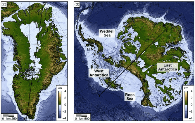
The visualization titled "Greenland and Antarctica Without Their Ice Sheets" presents a striking depiction of what these two vast regions would look like if their iconic ice cover were to disappear. This dramatic alteration reveals the underlying topography and geography that typically remains obscured beneath layers of ice. The map prompts us to consider not just the surface features of these areas, but the profound implications that the loss of ice would entail for global sea levels, ecosystems, and climate.
Deep Dive into Ice Sheets and Their Impact
Ice sheets are colossal masses of glacial ice that cover vast land areas, primarily found in Greenland and Antarctica. Greenland's ice sheet is the second-largest in the world, while Antarctica's ice sheet is the largest, containing about 60% of the world's fresh water. A fascinating aspect of these ice sheets is their role in regulating global sea levels. Currently, the melting of these ice sheets contributes significantly to rising sea levels—approximately 0.5 mm per year from Greenland and about 1.5 mm from Antarctica.
Interestingly, the map illuminates features such as ancient mountain ranges, river valleys, and coastal contours that are typically hidden from view. For example, without the ice, Greenland's rugged terrain would become more prominent, revealing a landscape marked by deep fjords, volcanic mountains, and plateaus. In contrast, Antarctica's dry valleys and mountain ranges would be starkly visible, showcasing a region that appears almost otherworldly.
The melting ice sheets would also lead to the exposure of subglacial lakes and rivers, altering the hydrology of these regions. Take, for instance, Lake Vostok in Antarctica, one of the largest subglacial lakes in the world, which remains insulated by miles of ice. As the ice melts, this lake could interact with the ocean, potentially influencing marine ecosystems and currents in ways we are just beginning to understand.
Moreover, the geographical features revealed by this map serve as a reminder of the past climate conditions that shaped these regions. During the last interglacial period, around 125,000 years ago, sea levels were significantly higher, and the landscapes we see today would have looked very different. This historical context helps us grasp the potential future scenarios as climate change accelerates the melting process.
Regional Analysis
Examining the map more closely, we can see distinct differences between Greenland and Antarctica. Greenland's terrain is more varied, with elevations reaching over 3,000 meters (9,800 feet) in the central region. The map reveals several prominent features such as the Greenland Ice Cap, which is characterized by its vast plateaus and deep fjords. As the ice recedes, areas like Disko Bay and the Nuup Kangerlua fjord would become crucial locations for new ecosystems to thrive, revealing potential for increased biodiversity.
Conversely, Antarctica is more uniform in its geography, dominated by the Antarctic Plateau. The map highlights features like the Transantarctic Mountains, which divide East and West Antarctica, and shows how the continent’s ice sheet covers vast expanses of flat land interspersed with mountain ranges. The unique landscape of Antarctica, including its dry valleys, presents an opportunity for scientists to study extremophiles—organisms that thrive in harsh conditions—offering insights into the resilience of life.
Significance and Impact
Why does this topic matter? The implications of ice sheet loss extend well beyond the picturesque landscapes revealed in the map. The melting of Greenland and Antarctica significantly impacts global sea levels, which could displace millions of people living in coastal regions. Projections indicate that if current trends continue, sea levels could rise by over a meter by the year 2100, with dire consequences for cities like Miami, New Orleans, and Jakarta.
Additionally, the changing landscapes could affect global weather patterns. The loss of ice alters albedo—the reflectivity of Earth's surface—potentially leading to accelerated warming and changes in precipitation patterns worldwide. This is a complex feedback loop that scientists are racing to understand.
In conclusion, the map of Greenland and Antarctica without their ice sheets is more than just a fascinating visualization; it serves as a crucial reminder of the ongoing impacts of climate change. As we continue to study these regions and their transitions, it is imperative to consider the broader implications for our planet's future. Understanding the geography beneath the ice not only informs us about past climates but also prepares us for the environmental challenges ahead.
Visualization Details
- Published
- October 20, 2025
- Views
- 50
Comments
Loading comments...