Topographic Map of the Indian Subcontinent

Alex Cartwright
Senior Cartographer & GIS Specialist
Alex Cartwright is a renowned cartographer and geographic information systems specialist with over 15 years of experience in spatial analysis and data...
Geographic Analysis
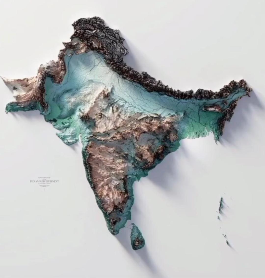
What This Map Shows
The topographic map of the Indian subcontinent is a detailed representation that illustrates the physical features of the land, including mountains, valleys, plains, and plateaus. This visualization provides insights into the diverse terrain that characterizes this region, making it a critical tool for understanding the geographical layout and the natural processes shaping the area. The subcontinent is marked by significant topographical variations that influence everything from climate patterns to human settlement.
Deep Dive into the Topography of the Indian Subcontinent
The Indian subcontinent is a tapestry of contrasting landscapes. At its heart lies the majestic Himalayas, the highest mountain range in the world, which stretches across five countries: India, Nepal, Bhutan, China, and Pakistan. Interestingly, the Himalayas are not just a physical barrier; they play a crucial role in the climate of the region. The towering peaks capture moisture-laden air from the Indian Ocean, resulting in heavy rainfall on their southern slopes. This phenomenon gives rise to the lush greenery of the Western Ghats and the northeastern states of India, which are among the wettest places on Earth.
To the north of the Himalayas lies the Tibetan Plateau, often referred to as the 'Roof of the World.' This high-altitude region is characterized by its arid climate and sparse vegetation, contrasting sharply with the more humid conditions found in the southern parts of the subcontinent. The plateau also serves as a crucial water source, feeding major rivers like the Indus, Brahmaputra, and Ganges, which are vital for the livelihoods of millions.
Moving southward, we encounter the Indo-Gangetic Plain, a fertile region that stretches from Punjab in the west to West Bengal in the east. This plain is one of the most densely populated areas in the world due to its rich alluvial soil, which supports extensive agriculture. Have you ever wondered why rice, wheat, and sugarcane are staple crops in this region? It's because of the favorable conditions created by the river systems flowing through this plain.
Further south, the Deccan Plateau emerges, characterized by its volcanic rock and distinct topography. This region has a unique climate, being shielded by the Western Ghats from the coastal monsoons. The Deccan is home to several major cities, including Hyderabad and Pune, which have seen rapid urban development in recent decades. The plateau also features important geological formations, including the Nilgiri Hills and the Western Ghats, both recognized for their biodiversity.
Regional Analysis
Analyzing the topographical variations across different regions of the Indian subcontinent reveals striking contrasts. For example, the northern regions, dominated by the Himalayas, experience harsh winters and significant snowfall, leading to glacial melt that feeds the rivers. In contrast, the southern coastal areas, like Tamil Nadu and Kerala, enjoy a tropical climate, which supports a diverse range of flora and fauna.
In the eastern part of the subcontinent, the Sundarbans mangrove forest is a unique ecosystem that thrives in the delta formed by the confluence of the Ganges, Brahmaputra, and Meghna rivers. This region is not just ecologically significant; it's also crucial for the local communities that depend on fishing and agriculture. However, rising sea levels due to climate change pose a significant threat to this delicate ecosystem.
Moving towards the western part, the Thar Desert in Rajasthan showcases a different side of the subcontinent's topography. This arid landscape is characterized by sand dunes and sparse vegetation, illustrating the diversity of environments present in the region. Interestingly, despite its harsh conditions, the Thar Desert is home to various nomadic communities that have adapted to the environment over generations.
Significance and Impact
Understanding the topography of the Indian subcontinent is essential for several reasons. Firstly, it informs us about the natural resources available in different regions, influencing economic activities such as agriculture, mining, and tourism. For instance, the fertile plains support agriculture, while the mineral-rich Deccan Plateau is crucial for mining industries.
Moreover, the topography has a profound impact on human settlement patterns. Urban areas often develop in regions with favorable topographical features that provide access to resources, transportation routes, and safety from natural disasters. As urbanization continues to rise, particularly in cities like Mumbai and Delhi, the implications of topographical constraints become increasingly significant.
Furthermore, the ongoing challenges posed by climate change, such as flooding in the low-lying areas and droughts in the western regions, highlight the need for effective environmental management and planning. Policymakers must consider topographical features when addressing these issues to develop sustainable solutions for future generations.
In conclusion, the topographic map of the Indian subcontinent offers not just a glimpse into its physical features but also serves as a reminder of the intricate relationship between geography and human activity. As we continue to study and understand these landscapes, we can better appreciate the complexities of life within this vibrant region.
Visualization Details
- Published
- October 18, 2025
- Views
- 72
Comments
Loading comments...