Simplified History Map of The British & Irish Isles

David Chen
Data Visualization Specialist
David Chen is an expert in transforming complex geographic datasets into compelling visual narratives. He combines his background in computer science ...
Geographic Analysis
What This Map Shows
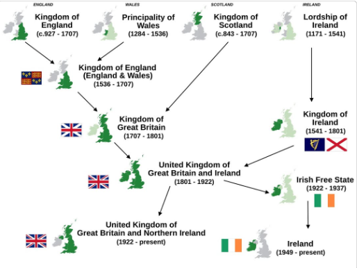
This visualization titled "Simplified History of The 4 Countries Of The British & Irish Isles" provides a clear overview of the historical developments and territorial changes that have shaped England, Scotland, Wales, and Ireland over time. The map outlines key historical events, conflicts, and cultural shifts that have led to the current political boundaries and identities of these regions. By breaking down complex histories into digestible segments, this map serves as a useful tool for understanding the intricate past of the British and Irish Isles.
Deep Dive into Historical Context
The history of the British and Irish Isles is a tapestry woven from various threads of conquest, colonization, and cultural exchange. England, Scotland, Wales, and Ireland each possess a unique narrative that contributes to the overarching story of the isles. Interestingly, the interactions among these countries have been characterized by both conflict and cooperation.
Starting with England, its rise as a powerful entity can be traced back to the Norman Conquest in 1066 when William the Conqueror transformed the political landscape. This event set the stage for the establishment of a centralized monarchy and the gradual expansion of English influence over the other regions. Throughout the Middle Ages, England engaged in numerous wars, including the Hundred Years' War with France and various conflicts with Scotland, which culminated in significant territorial shifts and changing allegiances.
Scotland, on the other hand, has a history marked by its fierce independence. From the early medieval period, when it emerged as a unified kingdom, Scotland resisted English domination. The famous Battle of Bannockburn in 1314 was a pivotal moment in Scottish history, where Robert the Bruce secured a significant victory. However, the eventual union with England in 1707 through the Acts of Union led to Scotland becoming part of a larger British state, though its distinct identity has persisted.
Wales, often overshadowed by its larger neighbor, has its own rich history of independence and struggle. The unification of Wales under the English crown in the 16th century was not without resistance, and the country has maintained a strong cultural identity, evidenced by the revival of the Welsh language and traditions. Interestingly, the devolution movements in recent decades have granted Wales greater autonomy, allowing it to reassert its unique heritage.
Ireland’s history is perhaps one of the most tumultuous. The long-standing conflict with England, marked by the English conquest in the 16th century and the subsequent establishment of Protestant rule, has left deep scars on Irish identity. The Great Famine in the mid-19th century further exacerbated tensions, leading to a push for independence. The partition of Ireland in 1921 resulted in the creation of Northern Ireland, which remains part of the United Kingdom, while the Republic of Ireland pursued a separate path as an independent nation, emphasizing its distinct cultural legacy.
Regional Analysis
When examining the territories represented on the map, we can observe stark contrasts in cultural and political developments. For instance, Northern Ireland has a complex identity shaped by both British and Irish influences, leading to ongoing sectarian tensions that are a direct result of its historical context. The Troubles, a violent conflict that spanned several decades, were rooted in historical grievances and differing national identities.
In contrast, the cultural renaissance in Wales showcases a different trajectory. The Welsh Parliament, established in 1999, symbolizes a significant reclamation of power and identity, highlighting the importance of local governance in preserving cultural heritage. Furthermore, Scotland's ongoing discussions about independence reflect a desire to redefine its historical narrative and assert its autonomy in a modern context.
Interestingly, the geographic proximity of these countries contributes to their intertwined histories. For example, trade routes across the Irish Sea have facilitated cultural exchange, while historical conflicts often spilled over borders, influencing public sentiments on both sides.
Significance and Impact
Understanding the historical context of the British and Irish Isles is crucial for grasping current socio-political dynamics. The colonial legacies, national identities, and ongoing debates about independence and autonomy all stem from the complex histories outlined in this map. For instance, the recent movements for Scottish independence and the implications of Brexit have reignited discussions about national sovereignty and identity.
Moreover, as globalization continues to reshape political landscapes, the historical narratives captured in this map remain relevant. The push for greater autonomy in regions like Wales and Scotland illustrates a broader trend of regionalism across Europe. In this era of interconnectedness, understanding these historical threads can foster better regional cooperation and cultural appreciation.
In conclusion, this map serves not just as a historical record, but as a lens through which we can examine the evolving identities and relationships of the British and Irish Isles. By appreciating the intricate history of these countries, we can better understand their current challenges and aspirations, paving the way for a more informed and empathetic dialogue about their future.
Visualization Details
- Published
- October 13, 2025
- Views
- 30
Comments
Loading comments...