Recent Earthquake in the Philippines Map

David Chen
Data Visualization Specialist
David Chen is an expert in transforming complex geographic datasets into compelling visual narratives. He combines his background in computer science ...
Geographic Analysis
What This Map Shows
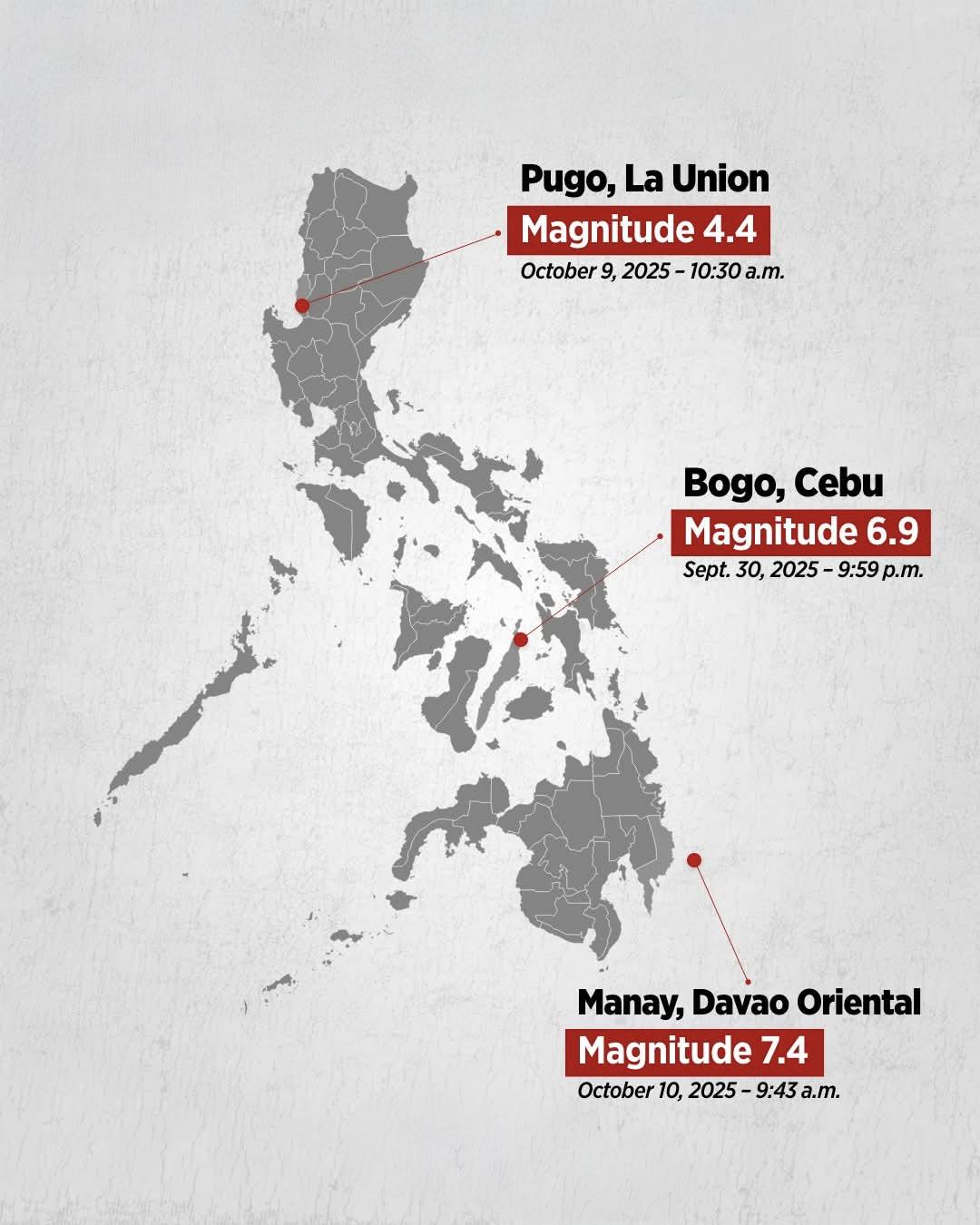
The "Recent Earthquake in the Philippines Map" provides a detailed representation of seismic activity within the archipelago, showcasing recent earthquake occurrences, their magnitudes, and epicenters. This visualization highlights how earthquakes are distributed across the islands, which are located along the Pacific Ring of Fire—a region notorious for its tectonic activity. By examining this map, we can gain insights into the geological dynamics of the Philippines and understand the risks associated with living in such a seismically active area.
Deep Dive into Earthquakes in the Philippines
Earthquakes are a natural phenomenon caused by the sudden release of energy in the Earth’s crust, resulting in seismic waves. The Philippines, being positioned on the converging boundaries between the Philippine Sea Plate and the Eurasian Plate, experiences significant tectonic activity. This makes it one of the most earthquake-prone countries in the world. According to the Philippine Institute of Volcanology and Seismology (PHIVOLCS), the Philippines records thousands of earthquakes each year, but only a fraction is felt.
Interestingly, the country’s most significant earthquake events are often linked to major tectonic faults. The Philippine Fault System, a major geological feature, runs the length of the archipelago and is responsible for many of the region's most powerful quakes. For instance, the magnitude 7.2 earthquake that struck Bohol in 2013 caused extensive damage, demonstrating the destructive potential of seismic events.
The recent earthquakes depicted in this map vary in magnitude and depth. Magnitudes can range from minor tremors that go unnoticed to catastrophic quakes exceeding 7.0. Notably, the depth of these earthquakes is also crucial; shallower quakes tend to cause more damage at the surface than deeper ones. In fact, the deadly 1990 Luzon earthquake, which had a magnitude of 7.7 and a shallow depth, resulted in significant casualties and infrastructural damage.
Understanding the distribution of earthquakes displayed on the map is vital for disaster preparedness. Areas with higher concentrations of seismic activity, such as Mindanao, are frequently monitored, and residents are educated on earthquake preparedness. Additionally, the Philippines has implemented building codes and disaster response strategies to mitigate risks associated with these natural disasters.
Regional Analysis
When analyzing the recent earthquake data on the map, one can see distinct patterns across different regions of the Philippines. Luzon, the largest island, is home to the capital, Manila, and experiences a variety of seismic activities, particularly along the Sierra Madre mountain range and the West Valley Fault. The latter is particularly concerning for residents of Metro Manila due to the potential for devastating earthquakes.
Meanwhile, Mindanao has been marked by significant seismic events as well. The region's complex geology, characterized by several active faults, has led to notable earthquakes, including a series of tremors in 2019 that affected various provinces. Interestingly, the map also shows that some remote areas experience earthquakes yet often lack the infrastructure to respond effectively.
Visayas, the central group of islands, serves as a bridge between Luzon and Mindanao. Its seismic activity, while less intense than that of Luzon and Mindanao, is still noteworthy. It has experienced its share of damaging earthquakes, such as the 2013 Bohol quake, which not only caused fatalities but also damaged historical landmarks, highlighting the region's vulnerability.
Significance and Impact
Understanding earthquake patterns in the Philippines is essential not only for local residents but also for urban planners, governments, and international aid organizations. The implications of these earthquakes extend far beyond the immediate physical damage. They affect economic stability, community resilience, and public health. For instance, the economic impact of a major earthquake can be devastating, disrupting local businesses and leading to costly rebuilding efforts.
Furthermore, with climate change leading to more extreme weather patterns, the interplay between natural disasters becomes increasingly complex. It raises questions about how communities can adapt and prepare for both earthquakes and the potential for other disasters like typhoons. Interestingly, the Philippines has been proactive in integrating disaster risk reduction in its development plans, emphasizing the importance of resilience in communities.
As we analyze this map and observe the recent seismic activity, it's vital to keep in mind that preparedness and awareness can save lives. The Philippines has a rich cultural heritage, and understanding the geological forces at play helps ensure that future generations can thrive in this beautiful and diverse archipelago.
Through educational initiatives and community engagement, we can better prepare for the inevitable earthquakes that will continue to shape the Philippines’ landscape. Have you noticed how awareness and education can significantly influence disaster response and recovery efforts? It's a fascinating aspect of geography that underscores the importance of knowledge in mitigating risks associated with living in a seismically active zone.
Visualization Details
- Published
- October 10, 2025
- Views
- 338
Comments
Loading comments...