16th Century Jester Map of the World

Marcus Rodriguez
Historical Geography Expert
Marcus Rodriguez specializes in historical cartography and geographic data analysis. With a background in both history and geography, he brings unique...
Geographic Analysis
What This Map Shows
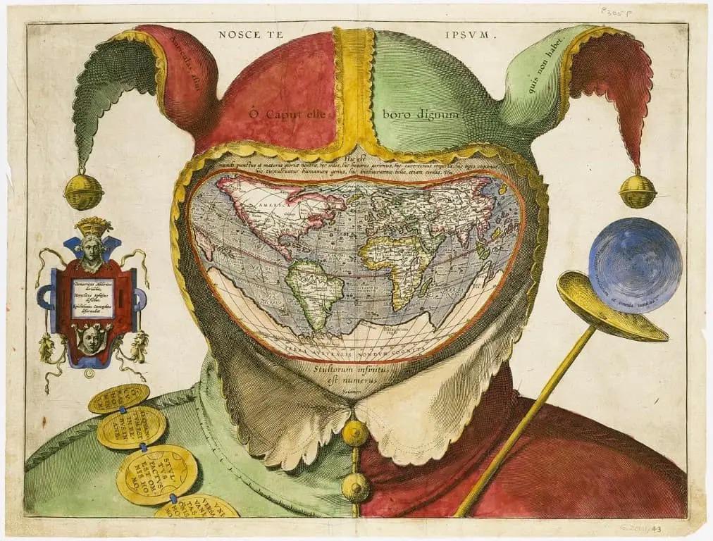
The enigmatic 16th-century cartographic work, "The map of the world in the head of a jester," presents a unique and thought-provoking visualization of the globe. Instead of the traditional geographic representation we might expect, this map creatively substitutes the face of a court jester for the world itself, offering a rich tapestry of continents and seas interwoven with societal commentary. The jester's features are crafted from the contours of landmasses, with oceans and rivers serving as the backdrop to this striking imagery. Accompanying Latin inscriptions, such as "Vanitas vanitatum et omnia vanitas" and "Stultorum infinitus est numerus," add layers of philosophical critique regarding human folly and the transient nature of worldly pursuits.
However, this map goes beyond mere artistic expression; it invites a deeper examination of the themes it embodies. At its core, it presents not just a geographical layout but also a reflection on the human condition—one that resonates through the ages. By analyzing the geographic elements depicted in this jester's visage, we can explore the broader implications of humanity's relationship with the world.
Deep Dive into Human Folly and Vanity
The jester, often perceived as a figure of humor and folly, serves as a powerful symbol of the inherent contradictions in human nature. The map reflects how geographic boundaries often mirror the arbitrary divisions we create, whether through politics, culture, or class. In this way, the map symbolizes not just physical geography but also the follies that arise from our ignorance and vanity.
Interestingly, the Latin phrase "Nosce te ipsum" or "Know thyself" invites us to consider our own understanding of the world. Have you ever wondered why certain regions are more affluent than others? The answer lies in the complexities of history, resources, and human ambition. For instance, Europe, depicted prominently in the jester's face, is characterized by a rich tapestry of cultural heritage and economic power, which stands in stark contrast to other regions that may struggle with development due to historical exploitation or environmental challenges.
As we delve deeper, we can examine how geographic features such as rivers, mountains, and deserts shape human activity. The rivers that weave through the map can be seen as lifelines for civilizations, serving as conduits for trade, culture, and communication. The Nile, Amazon, and Yangtze rivers have historically been central to the development of the societies that flourished along their banks. These waterways not only support agriculture but also influence migration patterns and urbanization.
What’s fascinating is that even in our contemporary world, these natural features continue to dictate human interaction and development. For example, cities like Cairo and London have thrived due to their access to significant waterways, while regions cut off from such resources often face economic hardships.
Regional Analysis
Examining the map through a regional lens allows us to appreciate the diversity of human experiences. In Europe, the compactness of nations and their interconnectivity foster a rich cultural exchange, yet it also breeds competition and conflict. Countries like Germany and France benefit from central location and economic strength, while others may lag behind.
Moving to Asia, we find a different narrative. The vastness of the continent means that geographic and cultural diversity is immense. Countries like China and India, with their sprawling populations and historical significance, illustrate both the richness and challenges of governance and resource management. The economic rise of these nations over the past few decades has reshaped global dynamics, yet they still face significant issues related to poverty and environmental sustainability.
In contrast, Africa, often depicted in a less favorable light on the map, represents a continent rich in resources but burdened by historical exploitation and political instability. Countries like Nigeria and South Africa are rich in potential yet face challenges that stem from both internal strife and external pressures.
Significance and Impact
Understanding the themes presented in "The map of the world in the head of a jester" is crucial as it highlights the folly of human hubris. The map serves as a reminder that as we pursue progress, we must remain grounded in self-awareness. The implications of this message are profound; they urge us to recognize our responsibilities toward each other and the planet.
In contemporary society, issues such as climate change, resource depletion, and geopolitical tensions illustrate the relevance of the map's themes. As we confront these global challenges, it becomes increasingly important to embrace a mindset of humility and introspection. The questions posed by the jester's map echo through time: Are we aware of our impact on the world? Are we learning from the follies of the past?
As we move forward, engaging with history through unique artifacts like this jester map can inspire us to approach our future with a sense of responsibility and awareness. After all, understanding our past is essential to shaping a better tomorrow.
Visualization Details
- Published
- October 9, 2025
- Views
- 32
Comments
Loading comments...