Map of Operation Al-Aqsa Flood Attacks Overview

David Chen
Data Visualization Specialist
David Chen is an expert in transforming complex geographic datasets into compelling visual narratives. He combines his background in computer science ...
Geographic Analysis
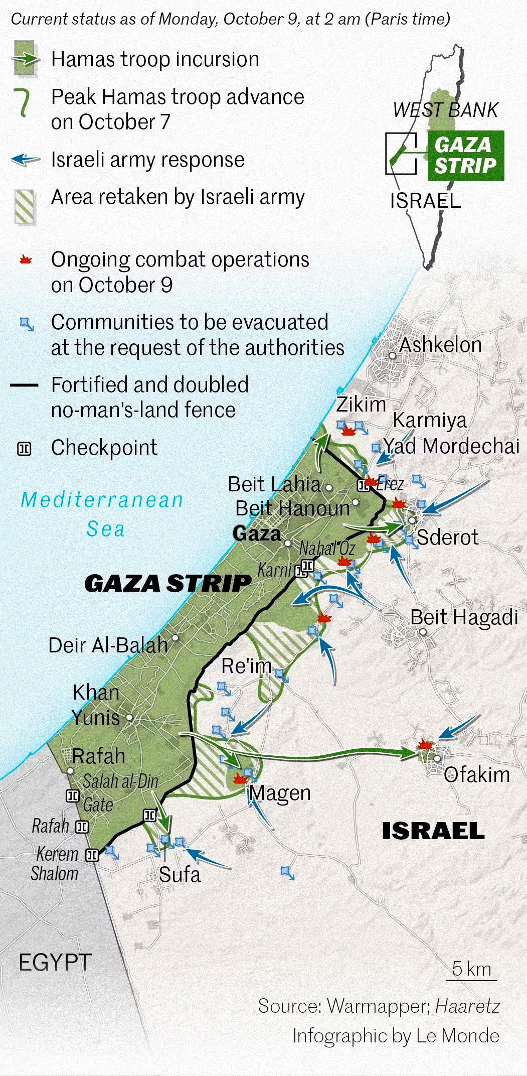
What This Map Shows\nThe 'Map of Operation Al-Aqsa Flood' provides a geographical visualization of the key locations and movements involved in the Hamas attacks on October 7th, 2023. This map highlights the regions of Israel and Gaza impacted during the initial days of the conflict, illustrating the areas most affected by military engagements, rocket launches, and subsequent responses from the Israeli Defense Forces (IDF).
As tensions escalated, this map serves as a crucial tool in understanding the geographical dynamics of the conflict. It delineates not only the frontlines of the violence but also the movement patterns of displaced populations and military responses, giving viewers a clearer picture of the situation on the ground during these critical days.
Deep Dive into the Conflict Landscape\nThe geography of the Israeli-Palestinian conflict is complex, shaped by decades of political tension, territorial disputes, and varying control over land. The recent attacks under 'Operation Al-Aqsa Flood' occurred in a landscape that is heavily urbanized and densely populated, particularly in Gaza, which spans roughly 140 square miles and houses approximately 2 million residents.
Interestingly, the map illustrates how geographical features, such as the proximity of Gaza to major Israeli cities like Ashkelon and Sderot, have significant implications for the conflict. Ever wondered why the attacks have such a profound impact on these areas? It's because the short distances involved mean that rocket fire can reach populated areas within minutes, leading to heightened levels of fear and urgency among civilians.
Moreover, the map highlights the varying responses and military logistics from both sides. For instance, the IDF’s operations are predominantly focused on areas along the Gaza border, where they can deploy ground troops and artillery most effectively. This spatial distribution forms a critical aspect of military strategy, as both sides navigate the challenges posed by urban warfare in densely populated settings.
In addition, the geographical layout also influences humanitarian issues. The map reveals the concentration of refugees fleeing from conflict zones, often moving towards areas perceived as safer, which can lead to overcrowding and increased strain on local resources. The narrow confines of Gaza make it exceedingly difficult for humanitarian aid to flow freely, exacerbating the already dire living conditions.
Regional Analysis\nAnalyzing the map reveals stark contrasts between various regions involved in the conflict. In southern Israel, cities like Be'er Sheva and Eilat have historically experienced less frequent attacks than the towns along the Gaza perimeter. This discrepancy can be attributed to the geographical distance from Gaza, as well as different military strategies employed by Hamas, which often focuses on more immediate targets.
Furthermore, the map illustrates the situation in the West Bank, which, while not the immediate focus of the attacks, is influenced by the escalating tensions. The geographical separation between Gaza and the West Bank creates a unique dynamic, as residents in these areas have different levels of access to resources and security. The West Bank's mountainous terrain contrasts sharply with the flat coastal plain of Gaza, affecting mobility and military operations.
Significance and Impact\nUnderstanding the geographical implications of the 'Operation Al-Aqsa Flood' is essential for grasping the broader context of the Israeli-Palestinian conflict. The map not only serves to inform viewers about the immediate aftermath of the attacks but also sheds light on long-term implications for regional stability. As the conflict evolves, the geographical landscape will continue to play a pivotal role in shaping military strategies, humanitarian responses, and international diplomacy.
What’s fascinating is that maps like this one can influence public perception and policy decisions. They serve as visual narratives that encapsulate the complexities of conflict, allowing individuals and leaders to better understand the stakes involved. With ongoing tensions, future maps will likely depict further changes in territorial control, population displacement, and military engagements, continuing to reflect the ever-evolving nature of this conflict.
In conclusion, the 'Map of Operation Al-Aqsa Flood' not only charts the immediate impacts of violence but also opens a dialogue about the geographic realities that underpin the Israeli-Palestinian conflict, emphasizing the need for nuanced understanding and solutions in the pursuit of peace.
Visualization Details
- Published
- October 7, 2025
- Views
- 50
Comments
Loading comments...