True Size of Every Country in Eurasia Map

Marcus Rodriguez
Historical Geography Expert
Marcus Rodriguez specializes in historical cartography and geographic data analysis. With a background in both history and geography, he brings unique...
Geographic Analysis
What This Map Shows
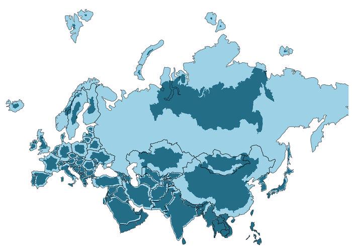
The visualization titled "The True Size of Every Country in Eurasia" provides a unique perspective on the geographical size of each country across this vast continent. By using a method that allows for the true proportional representation of land area, the map sheds light on the often-misleading perceptions of country sizes that we might have from conventional maps like the Mercator projection. This is particularly relevant in Eurasia, a region that encompasses some of the largest countries in the world, including Russia, China, and India, as well as a myriad of smaller nations. It reveals how our understanding of a country’s size can drastically change when viewed accurately on a flat plane.
Deep Dive into Country Sizes in Eurasia
Have you ever wondered why certain countries seem larger or smaller than they actually are? This phenomenon can be attributed to the way maps distort land areas to fit the spherical shape of the Earth onto a flat surface. The map in focus corrects these distortions, allowing us to see the true sizes of countries in Eurasia.
Eurasia is home to diverse geographical landscapes, ranging from the vast steppes of Kazakhstan to the mountainous terrains of the Himalayas in India and Nepal. For instance, while Russia is often depicted as a massive landmass on conventional maps, this visualization accurately represents its staggering size, making it the largest country in the world, covering over 17 million square kilometers. Interestingly, despite its vastness, approximately 77% of Russia's population resides in the western part, which is only a fraction of its total area.
Conversely, smaller nations like Armenia and Georgia, which might appear insignificant on distorted maps, come into clearer focus regarding their territorial extents. With around 29,743 square kilometers and 69,700 square kilometers respectively, these countries are quite substantial when seen in the context of their neighbors. They boast rich histories and diverse cultures that have shaped the region for centuries.
In terms of land area, the map also highlights the surprising size of countries like Kazakhstan, which is the ninth-largest country in the world, covering approximately 2.7 million square kilometers. It’s fascinating to note that despite its size, it has a relatively low population density, with vast stretches of land remaining uninhabited.
Additionally, this map allows us to appreciate the vast differences in land area among countries. For example, while China and India are often perceived as close in size, China's area is around 9.6 million square kilometers, making it significantly larger than India’s 3.29 million square kilometers. This size disparity has profound implications on their geopolitical strategies, resources, and population distributions.
Regional Analysis
Breaking down Eurasia into regions reveals intriguing contrasts. In Northern Eurasia, Russia dominates, but the landscape is starkly different in Central Asia, where countries like Uzbekistan and Kyrgyzstan showcase a more varied topography, featuring mountains and deserts. Uzbekistan, with an area of about 447,400 square kilometers, is the most populous country in Central Asia, highlighting the relationship between land size and demographic concentration.
Meanwhile, in East Asia, countries like Mongolia and Japan offer an interesting comparison. Mongolia, covering approximately 1.56 million square kilometers, is known for its expansive nomadic traditions, while Japan, with just about 377,975 square kilometers, supports a dense urban population in its major cities such as Tokyo. This contrast brings to light how geographic size does not always correlate with population density or economic power.
In South Asia, the size differences are equally compelling. The sheer land area of India compared to its neighbors like Nepal and Bhutan illustrates significant socio-economic implications. India’s size allows for a robust agricultural sector, whereas smaller countries may face challenges in sustaining their economies with limited arable land.
Significance and Impact
Understanding the true sizes of countries in Eurasia matters more than just geographical trivia. It has real-world implications, especially in terms of resource allocation, political power, and environmental management. Countries with larger land areas often possess greater natural resources, which can lead to economic advantages. For example, Russia's vast territories are rich in oil and natural gas, giving it significant leverage in global energy markets.
Moreover, as the world faces challenges like climate change and urbanization, recognizing the geographic realities of each country will be crucial for effective collaboration on international policies. Countries like Kazakhstan, which are located in sensitive ecological zones, will need to manage their resources carefully to mitigate environmental impacts.
In conclusion, the "True Size of Every Country in Eurasia" map not only reshapes our perceptions of land area but also invites us to consider the broader implications of geography in our interconnected world. As we continue to navigate complex global challenges, a clear understanding of each nation’s geographical context will be essential for making informed decisions and fostering cooperation across borders.
Visualization Details
- Published
- October 1, 2025
- Views
- 56
Comments
Loading comments...