Geometric Map of Galicia by Domingo Fontán

David Chen
Data Visualization Specialist
David Chen is an expert in transforming complex geographic datasets into compelling visual narratives. He combines his background in computer science ...
Geographic Analysis
What This Map Shows
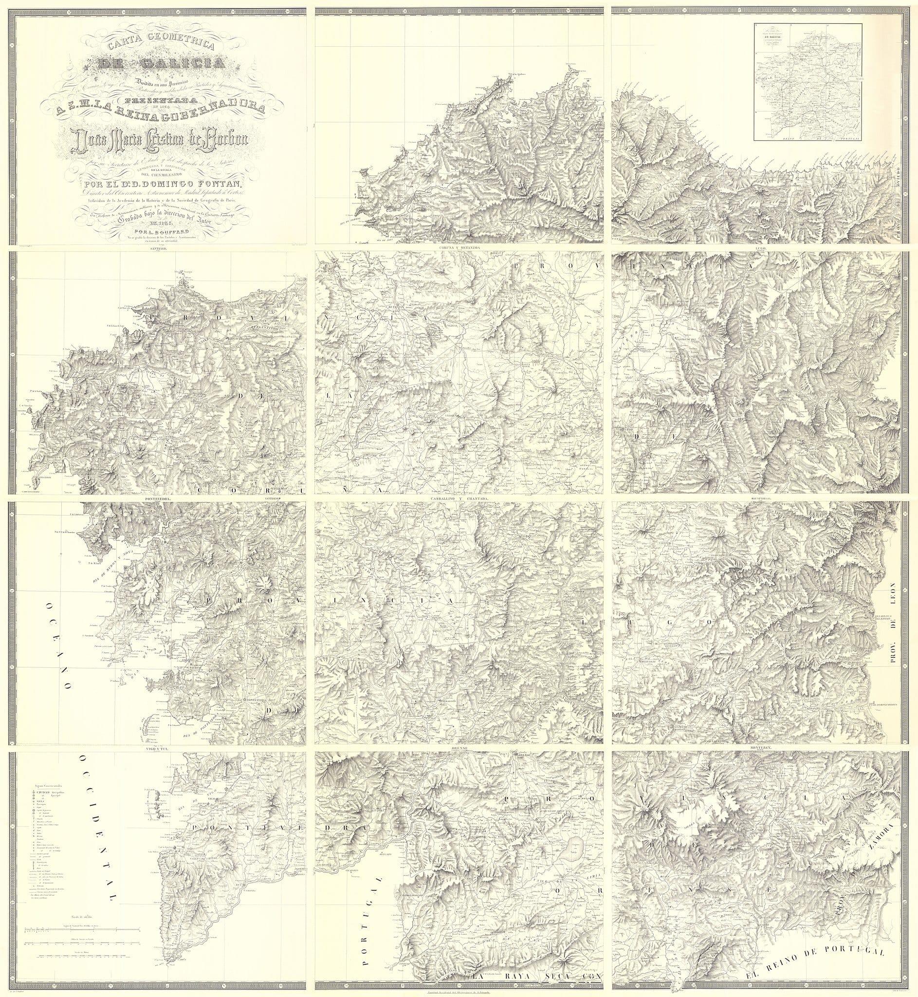
The "Carta Geométrica de Galicia" by Domingo Fontán, created in 1834, is a remarkable representation of the geographical landscape of Galicia, a region in the northwest of Spain. This map is noteworthy for its geometric precision and detail, showcasing the topographical features, settlements, and administrative divisions of the region during that time. Fontán's work stands out as one of the earliest attempts to accurately depict Galicia's geographical characteristics using scientific surveying techniques, making it a seminal piece in the history of cartography.
Deep Dive into Geographical Features of Galicia
Galicia is known for its diverse geographical features, which are vividly illustrated in Fontán's map. The region is characterized by its rugged coastline along the Atlantic Ocean, which includes numerous inlets, estuaries, and islands. Interestingly, the Rías Baixas and Rías Altas are particularly significant; these estuaries are formed by the drowned river valleys and are crucial for both biodiversity and the local fishing economy. Did you know that these areas are also famous for producing Albariño wine, a product that thrives in the unique climatic conditions created by the nearby ocean?
Inland, Galicia features a mix of mountainous terrain and fertile valleys. The Sierra de los Ancares and the Montes de León are prominent mountain ranges that contribute to the region's biodiversity and influence local weather patterns. The elevation variations create microclimates that support a variety of ecosystems, from lush forests to agricultural lands. The map illustrates these features, allowing viewers to appreciate the interplay between geography and climate.
What's fascinating is that Fontán's map also highlights the rivers that cut through the landscape, such as the Miño and the Ulla. These rivers are vital not only for their ecological roles but also for their historical significance in shaping human settlement patterns. The map indicates how these waterways facilitated trade and transportation, which were crucial for the development of the region's economy.
Regional Analysis
As we delve deeper into the regions depicted in Fontán's map, we can observe distinct geographical and cultural characteristics. For example, the coastal areas, particularly those near A Coruña, are heavily urbanized and serve as economic hubs. The map shows the concentration of settlements along the coast, indicating the importance of maritime activities.
In contrast, the inland areas, such as Ourense and Lugo, are more rural and less densely populated. These regions are characterized by agriculture and forestry, which are depicted in the map's detailed representations of land use. Interestingly, the differences in settlement patterns raise questions about how geography influences economic activities and population distribution. Why do you think some areas are more urbanized than others?
Furthermore, the map reflects the historical administrative divisions of Galicia, which can be compared to modern boundaries. Fontán's work laid the groundwork for understanding how these divisions impacted local governance and resource management. For instance, the delineation of parishes and municipalities can be seen as early attempts at organizing civic life in accordance with geographical realities.
Significance and Impact
The significance of Fontán's "Carta Geométrica de Galicia" extends beyond its artistic and cartographic merit. This map serves as a historical document that provides insights into the early 19th-century understanding of geographical space in Galicia. It underscores the importance of accurate mapping in facilitating regional planning and resource management, which remain relevant today.
In contemporary discussions about geography, understanding the physical landscape is crucial for addressing issues such as environmental conservation, urban planning, and climate change. As we face growing challenges related to land use and sustainability, looking back at detailed maps like Fontán's can inform our strategies for the future. Current trends indicate a renewed interest in regional planning that respects historical boundaries while accommodating modern needs. Have you noticed how maps continue to evolve alongside our understanding of geography?
In conclusion, the "Carta Geométrica de Galicia" is more than just a map; it is a window into the past that reveals the intricate relationship between geography, culture, and society. Whether you're a history buff or a geography enthusiast, Fontán’s map offers a rich tapestry of information worth exploring.
Visualization Details
- Published
- September 26, 2025
- Views
- 46
Comments
Loading comments...