Drive Time to Nando’s in the UK Map

David Chen
Data Visualization Specialist
David Chen is an expert in transforming complex geographic datasets into compelling visual narratives. He combines his background in computer science ...
Geographic Analysis
What This Map Shows
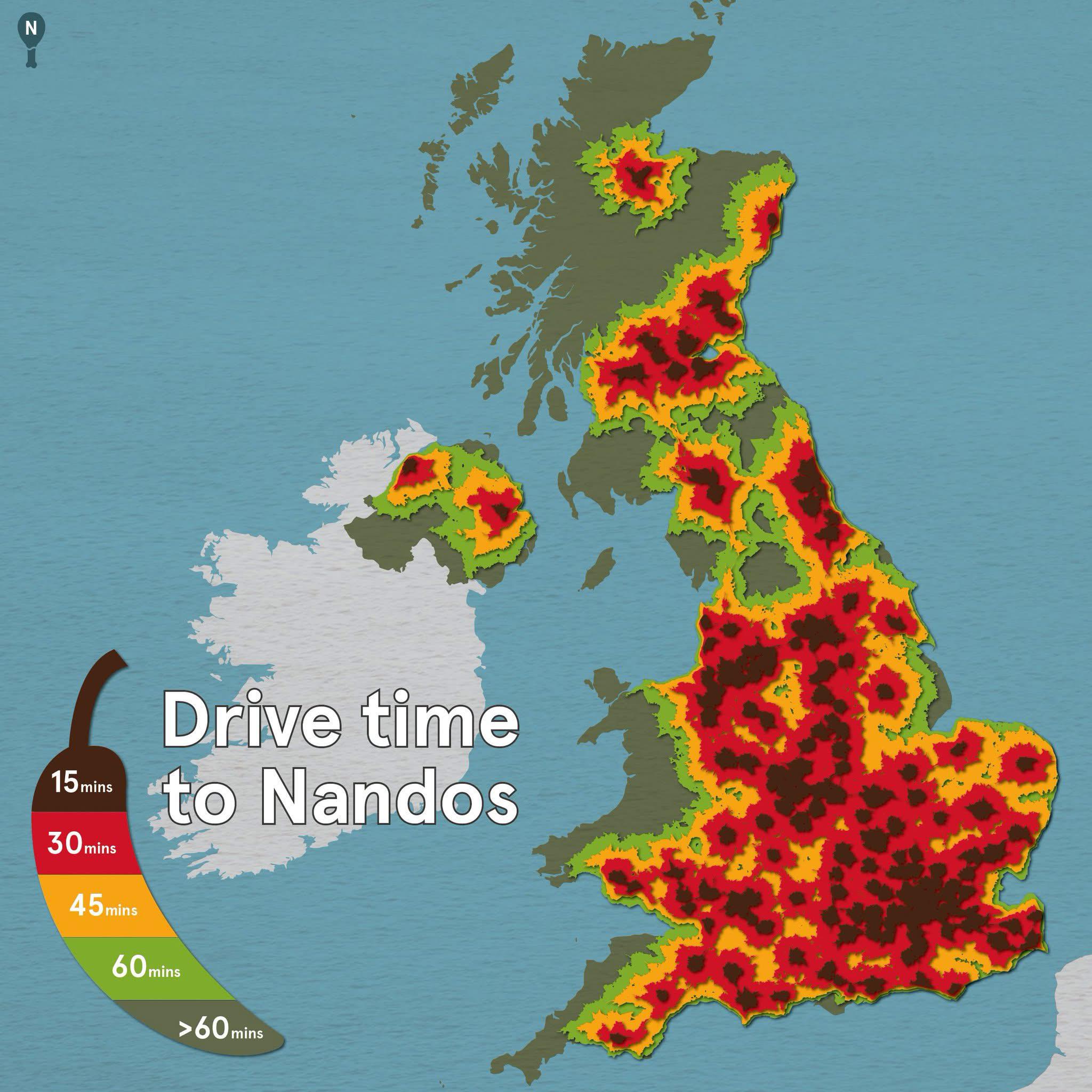
The "Drive Time to Nando’s in the UK" map provides a visual representation of how long it takes to reach various Nando’s locations across the country by car. This unique map highlights accessibility to one of the UK's favorite restaurant chains, known for its peri-peri chicken and vibrant atmosphere. By illustrating the time it takes to drive from different areas to the nearest Nando’s, this map offers insights into the geographical spread of the restaurant and the travel dynamics involved in reaching it.
Deep Dive into Fast Food Accessibility
Accessibility to dining options is an increasingly pertinent topic in urban geography. Fast food restaurants like Nando's are not only about food; they reflect cultural eating habits, economic factors, and urban planning. The average drive time to a fast food outlet can shed light on socio-economic disparities and population distribution in urban versus rural settings.
Interestingly, the rise of fast food chains has transformed dietary habits in the UK, with consumers often prioritizing convenience. According to recent statistics, fast food consumption has increased by over 15% in the past decade, highlighting a shift in lifestyle choices. These restaurants cater to busy individuals and families who may not have the time to prepare meals at home.
The prominence of Nando’s, in particular, can be attributed to its unique offering of grilled chicken, which stands out in a market saturated with burgers and fries. Furthermore, Nando’s has successfully marketed itself as a casual dining experience, appealing to younger demographics seeking a social dining atmosphere.
From a geographical perspective, the drive time to a Nando's can be influenced by several factors, including population density, road infrastructure, and urban planning policies. For instance, urban areas like London and Manchester typically have shorter drive times due to the higher concentration of restaurants and better road networks. In contrast, rural areas may experience longer drive times, reflecting fewer restaurant locations and less developed transport infrastructure.
Moreover, the variance in drive times also illustrates how cultural preferences are regionally influenced. For example, areas with a higher multicultural population may have more diverse dining options, including chains like Nando's that cater to varied tastes.
Regional Analysis
When examining the map, we can see distinct regional differences in accessibility to Nando's. In major metropolitan areas such as London, drive times to Nando’s locations are often under 15 minutes, thanks to the high density of outlets and efficient transport networks. For instance, residents in neighborhoods like Camden or Shoreditch can easily find a Nando’s within a short drive, underscoring the brand's popularity in urban centers.
Conversely, regions like the Scottish Highlands or parts of Wales exhibit longer drive times, often exceeding 30 minutes or more. These areas are characterized by lower population densities and fewer restaurants, reflecting broader trends in food accessibility in rural settings. Interestingly, this disparity raises questions about food equity, as residents in less accessible areas may rely heavily on home-cooked meals or local food sources.
In regions where Nando’s is present, the restaurant often becomes a community gathering place, reflecting local demographics and socio-economic conditions. The East Midlands, for example, showcases a unique blend of accessibility and community engagement, with drive times averaging around 20 minutes, providing a balance between urban and rural settings.
Significance and Impact
Understanding the geography of fast food accessibility can have significant implications. As urban areas continue to grow, so too does the need for accessible dining options that cater to diverse populations. This map is not just about how long it takes to reach a Nando's; it highlights broader themes of urban development, mobility, and lifestyle changes in the UK.
With the growing focus on health and nutrition, there’s a rising trend of consumers seeking healthier fast food options. Nando’s has capitalized on this trend by promoting its grilled chicken as a healthier alternative to traditional fast food items. Additionally, the company’s focus on sustainability and ethical sourcing of ingredients is becoming increasingly important to consumers, illustrating how geographical accessibility can intersect with ethical considerations in food choices.
In conclusion, the drive times to Nando’s in the UK map opens up conversations about food accessibility, urban planning, and cultural dining preferences. As we continue to navigate the complexities of modern eating habits, such visualizations serve as valuable tools for understanding how geography shapes our daily lives and choices.
Visualization Details
- Published
- September 26, 2025
- Views
- 44
Comments
Loading comments...