Turkey Population and GDP Distribution Map

David Chen
Data Visualization Specialist
David Chen is an expert in transforming complex geographic datasets into compelling visual narratives. He combines his background in computer science ...
Geographic Analysis
What This Map Shows
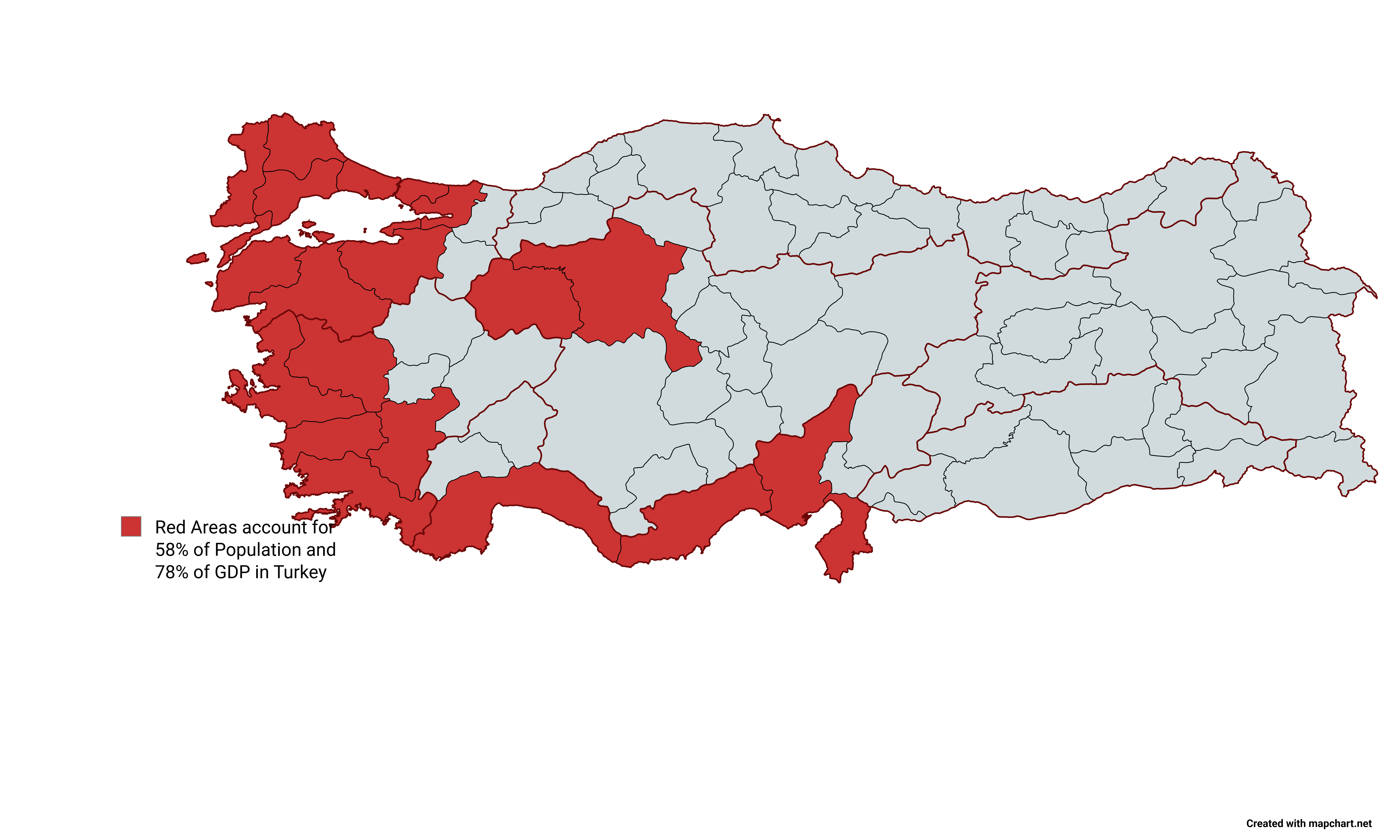
The map titled "Red Areas Accounts for 58% of Population and 78% of GDP in Turkey" visually represents the distribution of Turkey's population and economic output across different regions. The areas marked in red indicate the regions that collectively house over half of the country's population and generate a significant portion of its Gross Domestic Product (GDP). This stark visual contrast not only highlights population density but also underlines the economic disparities and urban concentration present in Turkey.
Deep Dive into Population and GDP Distribution
Turkey, a transcontinental nation straddling Eastern Europe and Western Asia, showcases a unique demographic and economic landscape. The country's population is estimated to be over 84 million, with a significant concentration in urban areas. In fact, urbanization has transformed Turkey's demographic fabric, with approximately 75% of its population now residing in cities. This migration trend has led to the emergence of vibrant urban centers, primarily in regions like Marmara, Aegean, and parts of Central Anatolia.
Interestingly, the red areas on the map represent key urban hubs such as Istanbul, Ankara, and Izmir. Istanbul, the largest city and economic powerhouse, is a prime example of this phenomenon. The city alone accounts for nearly 30% of Turkey's GDP, thanks to its diverse economy that includes finance, trade, and tourism.
These densely populated regions not only drive economic growth but also influence various socio-economic factors, such as education, healthcare, and employment opportunities. For instance, higher income levels are typically found in urban areas, where job prospects are abundant compared to rural regions, where agriculture predominates.
The disparity between urban and rural areas is stark. While the red regions flourish with economic activity, rural areas often struggle with lower GDP contributions and higher unemployment rates. This uneven distribution raises questions about resource allocation and development strategies, particularly as Turkey aims to enhance its overall economic performance.
Moreover, the concentration of population and economic activity in specific areas poses challenges, such as overcrowding, environmental degradation, and increased demand for infrastructure. Urban planners and policymakers must address these issues to ensure sustainable development moving forward.
Regional Analysis
Breaking down the map further reveals intriguing regional variances. The Marmara region, home to Istanbul, is not only the most populated but also the most economically productive, contributing around 40% of the national GDP. In contrast, the Eastern Anatolia region, which is less populated and economically active, faces significant challenges, including poverty and underdevelopment. This region accounts for less than 5% of the country’s GDP despite having a substantial land area.
The Aegean region, with cities like Izmir, also plays a crucial role, benefiting from trade and tourism due to its coastal location. Interestingly, the Central Anatolia region, including the capital Ankara, has a growing economic footprint, primarily due to its status as a political and administrative center. However, it still lags behind the more affluent coastal regions in terms of GDP per capita.
This regional contrast highlights the need for targeted economic policies that foster development in less affluent areas while managing the growth and sustainability of the bustling urban centers.
Significance and Impact
Understanding the population and GDP distribution in Turkey is essential for various reasons. For one, it provides insights into the socio-economic landscape of the nation, revealing disparities that could impact policy decisions. Have you noticed how urban centers often attract investment and talent while rural areas struggle? This phenomenon can lead to a cycle of neglect, making it crucial for the government to implement strategies that encourage balanced development.
Moreover, as Turkey continues to grapple with challenges such as housing shortages, transportation issues, and environmental concerns, this map serves as a vital tool for urban planners and decision-makers. By recognizing the regions that contribute most to the economy, stakeholders can better allocate resources and design policies aimed at improving living standards across the country.
In conclusion, the concentration of Turkey's population and economic output in specific red areas is not merely a statistic; it reflects a complex interplay of urbanization, economic development, and regional disparities. Addressing these challenges will be critical for Turkey's future growth and equity, paving the way for a more balanced and inclusive society.
Visualization Details
- Published
- September 22, 2025
- Views
- 60
Comments
Loading comments...