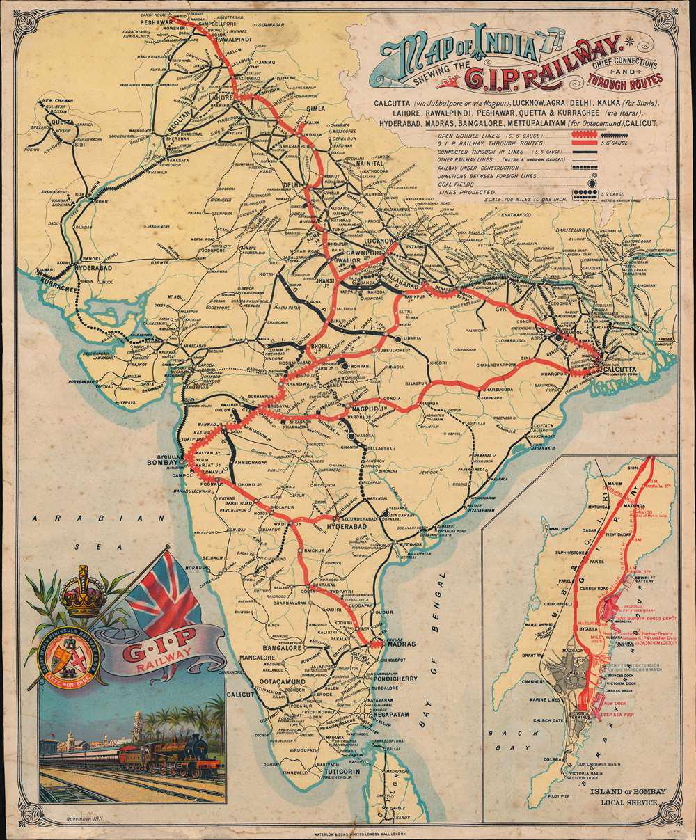
Railway Map of British India in 1911

Alex Cartwright
Senior Cartographer & GIS Specialist
Alex Cartwright is a renowned cartographer and geographic information systems specialist with over 15 years of experience in spatial analysis and data...
Geographic Analysis
What This Map Shows
This visualization presents the railway network of British India as it stood in 1911, reflecting a significant period during the British colonial era. The map distinctly marks passenger routes with red lines, highlighting the main rail corridors that facilitated movement for people across this vast subcontinent. In contrast, black lines indicate the railways primarily used for transporting coal and other goods, essential for fueling the industrial ambitions of the British Empire. The dotted lines signify railway lines that were under construction at the time, hinting at the expansion plans that were underway to enhance connectivity and exploit the region's resources further.
Deep Dive into Railway Development in British India
The railway system in British India was a monumental achievement and represented the technological advancements of the 19th and early 20th centuries. Spanning over 40,000 miles by 1911, it was one of the largest railway networks in the world at that time. The British saw the railways not only as a means to facilitate trade but also as a tool to consolidate control over the region.
Interestingly, the introduction of railways played a crucial role in transforming the socio-economic landscape of India. It enabled the movement of raw materials such as coal, iron, and agricultural produce to ports and factories, significantly contributing to the growth of industries. For instance, coal transported from the rich deposits in Jharkhand and West Bengal fueled the burgeoning industrial sector, while agricultural goods moved swiftly from rural areas to urban markets, reshaping consumption patterns.
Passenger services also expanded rapidly, making travel more accessible for the Indian populace. Railways connected major cities like Calcutta (now Kolkata) and Bombay (now Mumbai), providing a lifeline for commerce and communication. However, the railways were not just an economic tool; they also influenced cultural exchanges, with people from diverse backgrounds sharing experiences during their journeys.
The technology behind the railways was heavily influenced by British engineering practices, with a focus on broad gauge lines that enhanced stability and speed. This choice of gauge became a defining characteristic of the Indian railway system, and its implementation was crucial in determining the efficiency of transportation across the subcontinent.
Regional Analysis
Examining the map, we notice distinct regional railway patterns. In the north, cities like Lahore and Peshawar were well-connected, reflecting the importance of these regions as trade hubs. Railways facilitated the movement from these areas into the heart of India, linking up with the extensive network serving Delhi and Agra. Interestingly, the railways also connected regions that were historically significant, such as the routes leading to the Himalayan foothills, where towns like Kalka served as gateways to Shimla.
Moving southward, the railway network reached vital economic centers like Madras (now Chennai) and Bangalore, which were essential for agricultural output and trade. The southern railways played a pivotal role in transporting spices and textiles, further integrating local economies with the global market. Conversely, the western region, particularly around Bombay, served as a critical maritime link, facilitating international trade through its ports. The railways here connected the hinterlands to the bustling docks, ensuring that goods could be exported efficiently.
Interestingly, the dotted lines on the map indicate areas of future expansion, particularly in less developed regions. This foresight represented British aspirations to tap into the untapped resources of eastern India, where railways were seen as essential for promoting colonial interests. The construction of these lines would later foster economic development in areas that were previously isolated, showcasing the long-term impact of railway infrastructure.
Significance and Impact
The significance of the railway system in British India extends beyond mere transportation; it was a catalyst for modernization and economic transformation. The railways not only facilitated the movement of goods and people but also played a pivotal role in the political landscape, enabling the British to exert control over vast distances and diverse populations.
Today, the legacy of these railways is still evident in modern India, where the railway system remains one of the largest in the world, serving millions of passengers daily. However, the historical implications of railway construction during the colonial period are complex, intertwining narratives of exploitation and development. As we move forward, understanding this history helps us appreciate the intricate balance of heritage and progress in contemporary India.
In conclusion, the Railway Map of British India in 1911 serves as a window into a transformative era, showcasing how transportation infrastructure shaped the socio-economic fabric of the subcontinent. It prompts us to reflect on the implications of such developments, not just in historical contexts but also in understanding ongoing issues related to transportation, economy, and cultural exchange today.
Visualization Details
- Published
- September 22, 2025
- Views
- 36
Comments
Loading comments...