Thirteen Colonies Map of the United States

Marcus Rodriguez
Historical Geography Expert
Marcus Rodriguez specializes in historical cartography and geographic data analysis. With a background in both history and geography, he brings unique...
Geographic Analysis
What This Map Shows
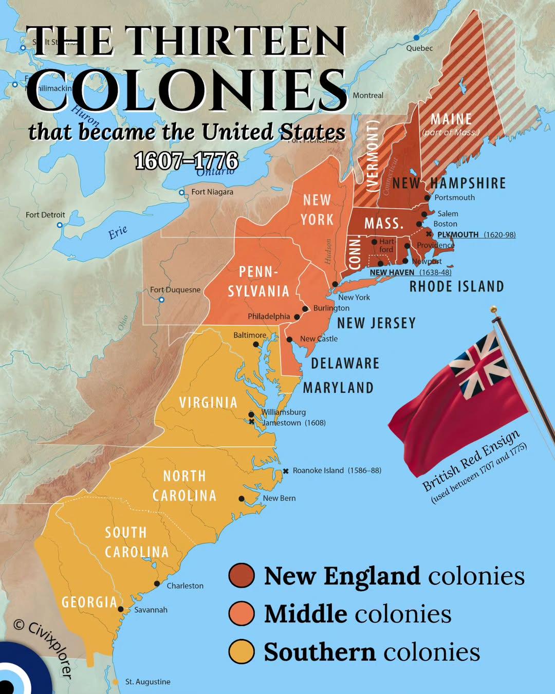
This map illustrates the geographic distribution of the thirteen colonies that ultimately formed the United States of America between 1607 and 1776. Each colony, with its unique geographical features and socio-economic characteristics, played a crucial role in the historical context leading up to the Revolutionary War. Understanding these colonies provides insight into the early American landscape and the diverse motivations for settlement that shaped the nation’s future.
Deep Dive into the Thirteen Colonies
The thirteen colonies were established primarily along the Atlantic coast and were divided into three distinct regions: New England, the Middle Colonies, and the Southern Colonies. This geographical categorization is not just a matter of location; it reflects significant differences in culture, economy, and governance that influenced the development of early American society.
In New England, which included colonies like Massachusetts, Rhode Island, and Connecticut, the harsh climate and rocky soil limited agricultural production. Consequently, these colonies developed a more diversified economy focused on trade, shipbuilding, and fishing. Interestingly, this region became a hotbed for early democratic ideals, partly due to the Puritan influence on community governance. Town meetings were common, and local governance was a fundamental aspect of life.
Conversely, the Middle Colonies, including New York, Pennsylvania, and New Jersey, boasted fertile land ideal for agriculture, leading to a diverse economy centered around farming grains, which earned the nickname "the breadbasket of America." The Middle Colonies were also notable for their religious and cultural diversity, as they attracted settlers from various European backgrounds, including Quakers, Dutch, and Germans. This multicultural environment fostered a unique social fabric that influenced the colonies' governance and economic practices.
Finally, the Southern Colonies, which encompassed Virginia, Maryland, the Carolinas, and Georgia, developed a plantation-based economy heavily reliant on cash crops such as tobacco, rice, and indigo. The fertile lands and warm climate made these colonies economically prosperous but also heavily dependent on enslaved labor, which had profound implications for social structures and human rights in America. The economic model established in the South would create lasting divisions in the United States that continue to resonate today.
What’s fascinating is how the geographical landscape influenced settlement patterns. Coastal access allowed for trade and communication, while the Appalachian Mountains created a natural barrier that affected westward expansion. The rivers flowing through these regions also played crucial roles in transportation and agriculture, shaping economic opportunities and community connections.
Regional Analysis
When we analyze the map regionally, the distinctions become even clearer. In New England, for example, the rocky terrain led to smaller farms and a focus on community-based industries. The population density was higher in urban centers like Boston, where trade flourished. This is in stark contrast to the Southern Colonies, where vast plantations dominated the landscape, and populations were more dispersed. Cities like Charleston emerged as significant economic hubs but remained fewer in number compared to their New England counterparts.
In the Middle Colonies, the combination of urban centers and rural areas created a unique demographic balance. Philadelphia, as one of the largest cities, became a cultural and economic melting pot, reflecting the region's diversity. The availability of rich agricultural land encouraged population growth, but the region also saw significant urban development, contributing to its economic vitality.
Significance and Impact
Understanding the thirteen colonies is essential not only for grasping the historical context of the United States but also for recognizing how these early settlements laid the foundation for modern American society. The varied economic models and cultural practices set the stage for future conflicts, including the American Revolution and the Civil War. Moreover, the legacy of these colonies can still be felt today in the political and social landscapes of the United States.
Today, the historical significance of the thirteen colonies serves as a reminder of the complexities of nation-building and the ongoing challenges of diversity and governance. As movements for social justice and equality continue to evolve, reflecting on this early period in American history can provide valuable lessons. Ever wondered how the geographical challenges of the past shape the social dynamics of the present? The answer lies in understanding how the early settlers adapted to their surroundings, influencing everything from agricultural practices to political ideologies.
In conclusion, the thirteen colonies map is not just a representation of geographical locations but a vivid tapestry of American history that reveals how geography, culture, and economy intertwined to shape the identity of a nation. As we continue to study these foundational aspects, we gain a deeper appreciation of the United States’ complex and rich history.
Visualization Details
- Published
- September 21, 2025
- Views
- 54
Comments
Loading comments...