Country Size Comparison Map with Western Australia

David Chen
Data Visualization Specialist
David Chen is an expert in transforming complex geographic datasets into compelling visual narratives. He combines his background in computer science ...
Geographic Analysis
What This Map Shows
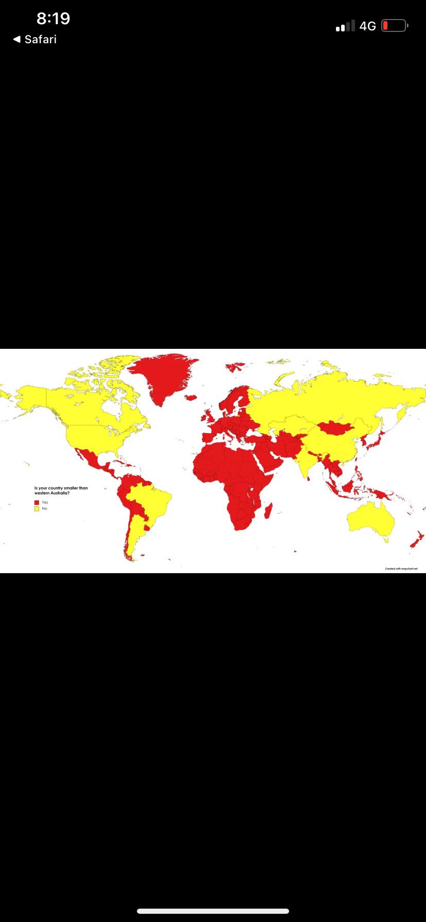
The visualization titled "Is your country smaller than the state of Western Australia?" provides a striking comparison of land areas between various countries and the state of Western Australia (WA). This map allows viewers to easily identify which nations have a smaller land area than WA, prompting a deeper understanding of geographical scales and the sizes of different countries around the globe. Western Australia, the largest state in Australia, boasts a vast area of approximately 2.65 million square kilometers (1.02 million square miles). This map effectively highlights the surprising fact that numerous countries, some of which are often perceived as significant on a global scale, are, in fact, smaller than this single state.
Deep Dive into Land Area and Geography
Land area is a fundamental aspect of geography that influences not just the physical landscape but also the population distribution, resource availability, and economic activities of a region. Western Australia, with its enormous expanse, is a great case study in understanding how land size can shape a nation or region's characteristics.
Interestingly, many countries that may come to mind when you think of vast nations, such as Japan or the United Kingdom, are actually smaller than WA, which can be quite surprising. For instance, Japan covers about 377,975 square kilometers, making it significantly smaller than Western Australia. Similarly, the UK spans approximately 243,610 square kilometers.
One of the key factors determining land area is geography's role in human settlement and economic development. Smaller countries often have denser populations and urbanized areas, while larger states like Western Australia are characterized by their vast, often sparsely populated regions. WA's landscape is dominated by arid deserts and rugged coastlines, which significantly influence its demographics and settlement patterns. Have you ever wondered how such a large area can support its economy primarily through mining and agriculture, given its challenging terrain?
In terms of demographics, Western Australia has a diverse population that is influenced by its size. The state is home to around 2.7 million people, concentrated mainly in the southwestern corner, particularly in cities like Perth. This is a stark contrast to smaller countries that might have similar population sizes but are densely packed, leading to different societal challenges and urban planning needs.
Regional Analysis
When analyzing the map's implications on a regional basis, it's fascinating to see that smaller nations often have distinct advantages and disadvantages. For example, countries like Luxembourg (2,586 square kilometers) and Malta (316 square kilometers) are not just smaller than WA, but they also boast high GDP per capita figures due to their economic structures, which are often service-oriented and highly developed.
On the other hand, regions within larger countries like the United States or Canada may have larger individual states or provinces that could dwarf many smaller nations. For instance, Alaska is over two and a half times larger than WA, while provinces like Quebec in Canada also have vast areas. However, the socio-economic dynamics in these larger regions can differ significantly from those in smaller nations, often leading to different political and environmental challenges.
Comparing the areas on the map reveals that many Caribbean nations such as Saint Kitts and Nevis (261 square kilometers) and Dominica (751 square kilometers) are substantially smaller than Western Australia. These nations often exhibit unique cultural and historical identities shaped by their size, isolation, and resources. It's intriguing to think about how geography influences cultural development and international relations.
Significance and Impact
Understanding the land area in relation to Western Australia is more than just a geographical curiosity; it has real-world implications. For instance, the comparisons made through this map underscore the importance of recognizing how geography influences resource allocation, environmental policies, and economic strategies. In larger regions like WA, the focus may be on mining and agriculture, while smaller nations might prioritize tourism or financial services.
Moreover, as climate change continues to impact various regions differently, the size of a country can play a crucial role in its adaptability and resilience. Larger states may have more resources at their disposal to address environmental issues, whereas smaller countries might face existential threats more acutely due to their limited land and resources.
Current trends indicate that as populations grow and climate challenges mount, the geopolitical significance of land area will likely shift. Understanding these dynamics can help us anticipate future challenges, whether they relate to resource scarcity or migration patterns. Have you considered how the size of a country could determine its political influence or economic stability in an increasingly interconnected world?
In conclusion, the map highlighting countries smaller than Western Australia opens up a world of discussion regarding land area, resources, and their implications on society. Exploring these geographical relationships enhances our understanding of the world around us and the diverse ways in which geography shapes human experience.
Visualization Details
- Published
- September 16, 2025
- Views
- 62
Comments
Loading comments...