Fractal Dimension of Isolines Map

David Chen
Data Visualization Specialist
David Chen is an expert in transforming complex geographic datasets into compelling visual narratives. He combines his background in computer science ...
Geographic Analysis
What This Map Shows
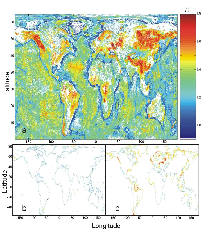
This visualization titled "Map of Fractal Dimension of Isolines" reveals the fractal dimensions of isolines across the globe. Each point on the map corresponds to a geographical region defined by a 0.1° latitude by 0.1° longitude grid. The color coding indicates the average fractal dimension of isolines for that specific area, with values ranging from 1.0 to about 1.8. This map not only highlights the fractal nature of isolines at varying altitudes and depths but also provides insight into the underlying geological processes that shape our planet.
Deep Dive into Fractal Dimensions
Fractal dimensions offer a unique lens through which to examine the complexity of natural features. In geography, isolines—or contour lines—represent areas of equal value, such as elevation, temperature, or pressure. Understanding the fractal dimension of these lines allows us to quantify how convoluted or intricate these features are. A fractal dimension close to 1 indicates a relatively smooth line, while a dimension approaching 2 suggests a more complex, convoluted structure.
Interestingly, fractal dimensions have been extensively studied in coastal geography, where they often reflect the degree of irregularity in coastlines. However, this map extends the concept of fractal dimensions beyond coastlines to all isolines, including those found in terrestrial landscapes and oceanic depths. For instance, the study referenced in the visualization shows that at a depth of -100 meters, the fractal dimension is relatively low due to the smoothing effects of water erosion and sedimentation. In contrast, as we move above sea level to areas around 100 meters altitude, we observe a notable increase in fractal dimensions, indicating a more rugged terrain with pronounced geological features.
This shift in fractal dimension not only highlights the varying geological processes at play but also reflects the diverse landscape that exists around the world. For instance, mountainous regions often exhibit higher fractal dimensions due to their steep slopes and complex topography, while flatter areas tend to have lower values. This characteristic can help geologists and environmental scientists understand the processes that shaped these landscapes over geological time scales.
Regional Analysis
When examining the map by region, significant variations in fractal dimensions emerge. For example, consider the Himalayas, where the fractal dimension of isolines is likely to be on the higher end of the spectrum. The dramatic topography, with its rugged peaks and deep valleys, creates a complex network of isolines that reflects the region's geological history of uplift and erosion.
Conversely, regions such as the Great Plains in North America present a different picture. Here, the fractal dimension is expected to be lower, reflecting the relatively smooth and flat terrain. The geological processes at play in these areas involve less dramatic shifts in elevation, leading to more uniform isoline patterns.
In coastal zones, the fractal dimensions can vary widely as well. Areas prone to significant erosion, such as the eastern shores of the United States, may show higher fractal dimensions due to the intricate shapes formed by the interplay of land and water. In contrast, more stable coastal regions may exhibit lower fractal dimensions, indicating less complexity in their isoline structures.
Significance and Impact
Understanding the fractal dimensions of isolines is more than just an academic exercise; it has real-world implications in fields such as geology, environmental science, and urban planning. For geologists, these fractal models can inform predictions about natural disasters such as landslides or flooding by providing insight into terrain stability. Environmental scientists can use fractal dimensions to study habitat diversity, as areas with more complex isolines often support a greater variety of ecosystems.
Moreover, as urban areas continue to expand, understanding the fractal nature of landscape features becomes increasingly important. Urban planners can leverage these insights to create more sustainable cities that work harmoniously with the natural contours of the land. Have you noticed how cities often develop along certain geographical features? This phenomenon is influenced by the fractal dimensions of the landscape, impacting everything from infrastructure development to environmental conservation.
In conclusion, the "Map of Fractal Dimension of Isolines" serves as a powerful tool for understanding the complexities of our planet’s surface. By examining the intricacies of isolines, we gain a deeper appreciation for the geological processes that shape our world, reminding us of the beautiful complexity inherent in nature.
Visualization Details
- Published
- September 14, 2025
- Views
- 58
Comments
Loading comments...