Topographic Map of Ukraine

Marcus Rodriguez
Historical Geography Expert
Marcus Rodriguez specializes in historical cartography and geographic data analysis. With a background in both history and geography, he brings unique...
Geographic Analysis
What This Map Shows
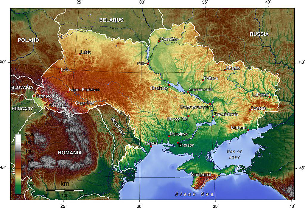
The Topographic Map of Ukraine provides a detailed visualization of the country's diverse terrain, showcasing its elevation changes, landforms, and physical features. From the majestic Carpathian Mountains in the west to the expansive plains of the central and eastern regions, this map captures the rich geographical tapestry of Ukraine. It highlights key features such as rivers, valleys, and natural resources, which play a vital role in shaping the country’s ecology and human activities.
Deep Dive into Ukraine's Topography
Ukraine's topography is characterized by a mix of lowlands, plateaus, and mountain ranges, making it one of the most geographically diverse countries in Eastern Europe. Covering an area of approximately 603,500 square kilometers, Ukraine has a varied landscape that significantly influences its climate, agriculture, and settlement patterns.
The Carpathian Mountains, which stretch across the western border, rise to an elevation of over 2,600 meters at their highest peak, Hoverla. This mountain range is not only a crucial watershed for the region but also supports a rich biodiversity, including many endemic species. Interestingly, the Carpathians are part of a larger system that extends into neighboring countries, showcasing the interconnectedness of regional geography.
In contrast, the central and eastern parts of Ukraine are dominated by vast plains known as the Steppe, characterized by fertile soil that has earned Ukraine the title of the "breadbasket of Europe." This fertile land is crucial for agriculture, supporting the cultivation of grains like wheat and barley. The black soil, known as Chernozem, is particularly rich in nutrients, making it one of the most productive soils in the world.
The Dnieper River, one of Europe's major rivers, flows through the heart of Ukraine, acting as a vital waterway for trade and transportation. Spanning over 2,200 kilometers, it has been instrumental in the development of cities like Kyiv and Dnipro. The river’s basin is home to numerous lakes and wetlands, which provide critical habitats for wildlife and serve as important resources for fishing and recreation.
Additionally, the Crimean Peninsula, with its unique topography and climate, stands out geographically. The peninsula features a mix of mountains and coastal areas, contributing to its popularity as a tourist destination. However, the region's geopolitical significance cannot be overlooked, as its landscape has been at the center of territorial disputes, impacting both its ecological and cultural heritage.
Regional Analysis
When examining Ukraine's topography regionally, we can observe distinct differences that shape local economies and lifestyles. In the western regions, such as Transcarpathia, the mountainous terrain supports a tourism industry centered around winter sports and hiking. The picturesque landscapes attract visitors, enhancing the local economy.
Conversely, the central regions, like Kyiv and Cherkasy, benefit from the fertile plains that dominate the area. Here, agriculture thrives, with large-scale farming operations producing significant yields of grains and sunflower oil. Interestingly, these areas also see urban development, with cities expanding outward from their historical cores, leading to a mix of rural and urban dynamics.
In the eastern part of the country, particularly in the Donetsk and Luhansk regions, the topography features rolling hills and valleys, but the landscape is heavily impacted by industrial activities, particularly coal mining. This has led to environmental concerns, including soil degradation and pollution, which affect local communities and ecosystems.
Significance and Impact
Understanding Ukraine's topography is essential for several reasons. Firstly, it provides insight into the country’s agricultural potential and natural resource distribution, both of which are significant for economic development. The fertile plains have historically made Ukraine a major grain exporter, contributing to global food security.
Moreover, topographical features influence climate patterns across the country, affecting everything from rainfall distribution to temperature variations. This, in turn, impacts agricultural practices and biodiversity. As climate change continues to pose challenges, understanding these geographical nuances becomes increasingly vital for effective environmental management and adaptation strategies.
Finally, the geopolitical implications of Ukraine's topography cannot be ignored. The diverse landscape has shaped historical conflicts and territorial disputes, particularly in regions like Crimea and the eastern provinces. As Ukraine navigates its path forward, the interplay between geography and politics remains a critical consideration.
In conclusion, the Topographic Map of Ukraine not only highlights the country’s physical characteristics but also serves as a lens through which we can understand its ecological, economic, and geopolitical complexities. As we look to the future, the topography will undoubtedly continue to play a pivotal role in shaping the nation’s identity and development.
Visualization Details
- Published
- September 11, 2025
- Views
- 68
Comments
Loading comments...