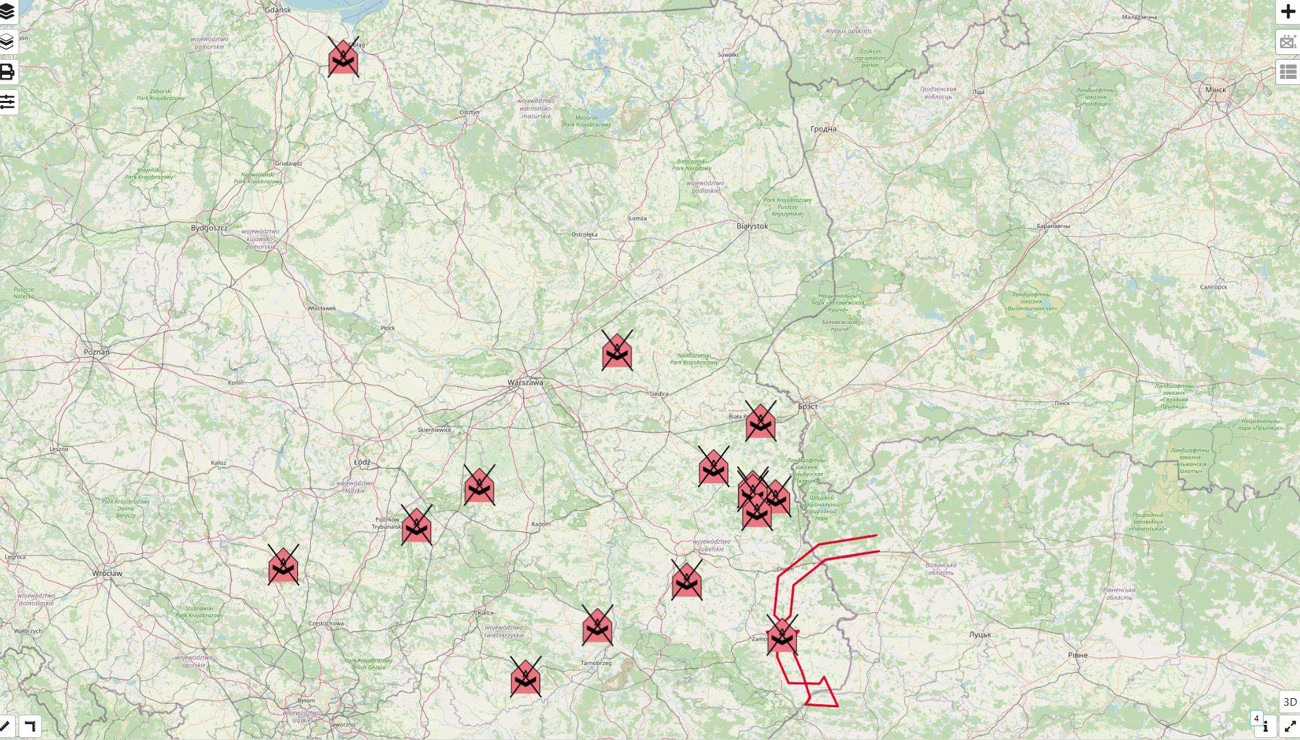
Map of Locations Where Poland Shot Down Russian Drones

Marcus Rodriguez
Historical Geography Expert
Marcus Rodriguez specializes in historical cartography and geographic data analysis. With a background in both history and geography, he brings unique...
Geographic Analysis
What This Map Shows
This map provides a detailed visualization of the locations in Poland where Russian drones were shot down. Specifically, it illustrates 15 distinct sites across the country where these unmanned aerial vehicles (UAVs)—identified as Gerber decoys—were recovered. Notably, some of these drones were equipped with additional fuel tanks, enhancing their operational range significantly, from approximately 600 kilometers to potentially 900 kilometers. This information sheds light on both the geographical distribution of drone activity and the implications for regional security.
Deep Dive into Drone Technology and Usage
Drones have revolutionized modern warfare and reconnaissance, providing strategic advantages on the battlefield. The Gerber decoy drones, in particular, are designed to mimic the signatures of more advanced military UAVs. This makes them valuable for misleading enemy defense systems and testing their response capabilities. Interestingly, the use of decoys is not new; militaries have employed such tactics for decades to gain the upper hand in aerial operations.
The fact that these drones were found across multiple locations in Poland suggests a systematic approach to utilizing drone technology for reconnaissance or even psychological operations. The ability of these drones to carry additional fuel tanks indicates an evolving strategy, allowing them to operate at greater distances from their launch points. This capability poses a significant concern for national security, as it enables the potential for surveillance or attacks deeper into enemy territory.
Moreover, the operational range of these drones—now between 700 to 900 kilometers—raises questions about the strategic intentions behind their deployment. As we analyze the trajectory of drone warfare, it's clear that nations are increasingly investing in UAV technology to enhance their military capabilities. The implications of this are profound, as it necessitates a reevaluation of air defense systems and counter-drone technologies.
Regional Analysis
When looking at the map, it's evident that the locations of the downed drones span various regions across Poland. Some areas, particularly near the borders, have seen a higher frequency of drone activity. For instance, eastern regions may experience heightened surveillance due to their proximity to conflict zones. In contrast, western areas could indicate a different strategic focus, perhaps aimed at testing NATO's response capabilities.
The geographical spread of these incidents is not merely random. It reflects broader geopolitical dynamics, including Poland's role within NATO and its proximity to the ongoing conflict in Ukraine. The map suggests a calculated deployment of drone technology, perhaps to gauge Poland's air defense readiness and to assess potential vulnerabilities in the region.
Interestingly, some of the locations where these drones were found are close to key military installations. This raises the possibility that the drones were not just random decoys but part of a broader strategy to gather intelligence on Polish military capabilities or to provoke a response.
Significance and Impact
The implications of this map extend beyond mere geographical data; they touch on critical issues of national security and international relations. Understanding where these drones have been shot down allows us to grasp the evolving nature of modern warfare, especially in the context of Eastern European geopolitics. As tensions continue to rise, the ability of nations to respond effectively to aerial threats is paramount.
Moreover, the ongoing development of drone technology will likely shape future military strategies worldwide. Countries are increasingly aware of the need for robust air defense systems, which can counter not only traditional aircraft but also the growing threat posed by UAVs. The presence of decoys such as the Gerber drones shows that adversaries are adapting and enhancing their tactics to exploit weaknesses in air defense.
In conclusion, the locations marked on this map are more than just dots on a geographical representation; they represent a critical front in the ongoing conflict and highlight the need for vigilance and preparedness in an age where drone technology is becoming increasingly sophisticated and prevalent. As we look to the future, monitoring these developments will be essential for gauging the evolving landscape of military strategy and international security.
Visualization Details
- Published
- September 11, 2025
- Views
- 86
Comments
Loading comments...