Eurasian Ice Sheets and Sea Level Map

David Chen
Data Visualization Specialist
David Chen is an expert in transforming complex geographic datasets into compelling visual narratives. He combines his background in computer science ...
Geographic Analysis
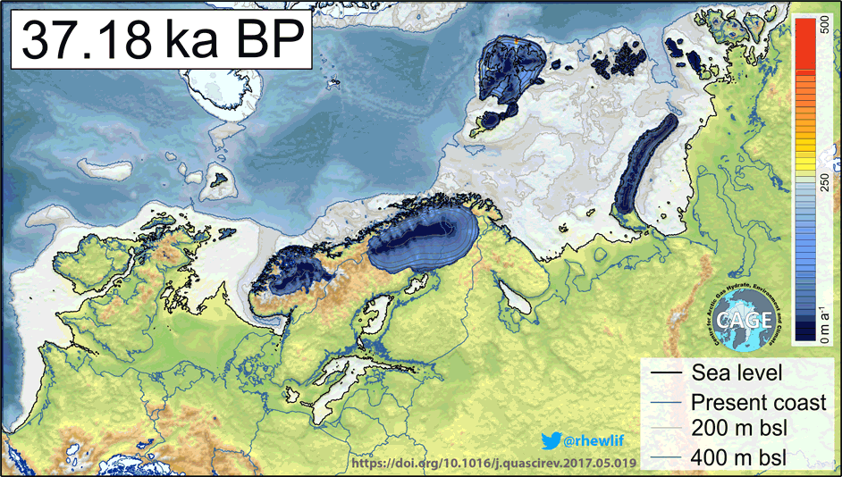
What This Map Shows
This map visualizes the distribution of Eurasian ice sheets and the corresponding sea levels during the Upper Paleolithic, specifically between 35,000 BCE and 6,000 BCE. It captures a pivotal moment in Earth's climatic history, illustrating how massive ice sheets sculpted the landscape of Europe and Asia, impacting not only the geography but also the human societies that inhabited these regions. The map highlights key features such as the extensive glacial coverage in Scandinavia, the formation of the Baltic Sea basin, and the fluctuating ice extent in Great Britain, particularly during the Younger Dryas period.
Deep Dive into Ice Sheets and Sea Levels
During the Upper Paleolithic, the most notable geological features were the vast ice sheets that covered significant portions of Eurasia. These ice sheets were remnants of the last glacial period, a time when Earth's climate was much colder than today. The Scandinavian Ice Sheet, in particular, played a crucial role in shaping the geography of Northern Europe. Its immense weight caused the land beneath it to depress, altering drainage patterns and influencing sea levels.
Interestingly, the ice sheets acted as natural barriers, impacting migration routes for prehistoric humans. The formation of the Baltic Sea was a direct consequence of these glacial movements. As the ice retreated, it left behind deep basins that would later fill with water, creating the unique maritime landscape we see today. This transformation is particularly evident in the map's depiction of the Baltic Sea, which was almost entirely encased by ice at certain points, presenting a stark contrast to the vibrant waterways that would emerge later.
Moreover, the map illustrates the complex network of river systems that formed as the glaciers melted. The meltwater from the ice sheets contributed to the rise in sea levels, leading to the development of extensive river valleys. These river systems were crucial for the Magdalenian people, who inhabited these regions. Rivers provided not only a source of freshwater but also a means of transportation and a rich ecosystem for hunting and gathering.
Have you ever wondered how these early humans navigated such landscapes? Crossing these river valleys would have required great skill and knowledge of the terrain. For instance, the melted waters from the glaciers would create fast-flowing rivers, requiring the Magdalenian people to adapt their hunting strategies and settlement patterns based on seasonal changes in water levels.
The Younger Dryas period, marked by a sudden return to glacial conditions around 12,900 to 11,700 years ago, saw the expansion of glaciers in Great Britain. This brief but significant climatic shift would have redefined the environment for those living in the area, further complicating their interactions with the landscape.
Regional Analysis
When analyzing the ice sheets and sea levels across different regions of Eurasia, notable contrasts emerge. Scandinavia, with its thick ice coverage, profoundly shaped the surrounding areas. The ice sheet's movement created distinct geological features, such as fjords along the Norwegian coast, which are still visible today. In contrast, the British Isles experienced a more complex interplay of glacial periods and interglacial warm phases. The map reveals how ice sheets waxed and waned, affecting the landscape and ecosystems in varying degrees.
In Eastern Europe, the Carpathian and Balkan regions were influenced by the proximity of the glaciers, leading to unique river systems that would later support early human settlements. The Danube River, for example, is believed to have been a vital artery for movement and trade during this time.
Interestingly, the map also highlights the draining of large lakes and rivers due to the retreat of the glaciers, which would have had significant implications for the flora and fauna of the regions. These changes not only impacted the environment but also played a role in the cultural developments of the people living there.
Significance and Impact
Understanding the dynamics of the Eurasian ice sheets during the Upper Paleolithic is crucial for comprehending the broader narrative of human history. The geographical changes brought about by these ice sheets influenced not only the migration patterns of prehistoric peoples but also the development of their societies. As the ice receded and landscapes transformed, it opened new avenues for exploration and resource utilization.
Today, studying such geological history helps us appreciate the profound impacts of climate change on our environment. It serves as a reminder of the planet's dynamic nature and the potential consequences of current climate trends. As we face rapid changes in our climate today, reflecting on these ancient transformations can provide valuable insights into how human societies can adapt to new environmental challenges.
In conclusion, the map of Eurasian ice sheets and sea levels during the Upper Paleolithic offers a fascinating glimpse into a world shaped by ice, water, and human resilience. It invites us to explore the intricate connections between geography and the evolution of human societies, a story that continues to unfold even in our modern age.
Visualization Details
- Published
- September 11, 2025
- Views
- 72
Comments
Loading comments...