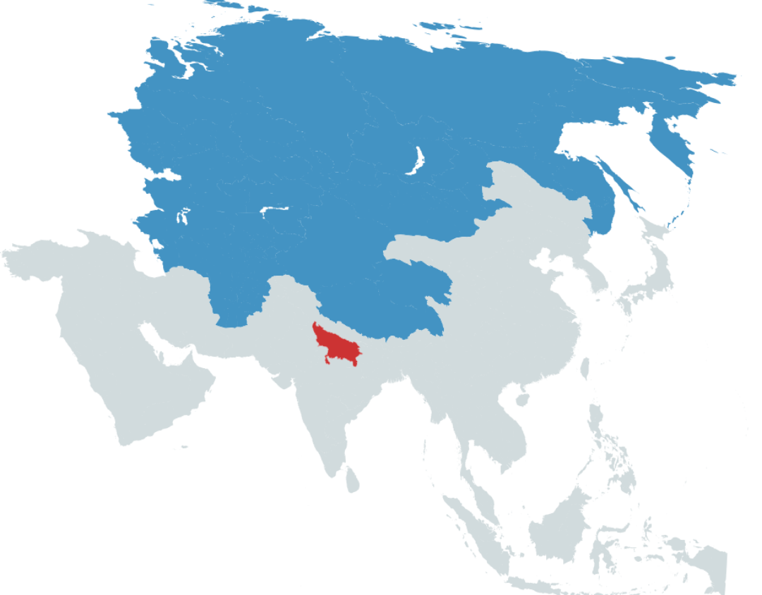
Population Comparison Map of Uttar Pradesh and Asia

Alex Cartwright
Senior Cartographer & GIS Specialist
Alex Cartwright is a renowned cartographer and geographic information systems specialist with over 15 years of experience in spatial analysis and data...
Geographic Analysis
What This Map Shows
This intriguing map visualizes an eye-opening comparison of population densities across vast regions, focusing on the surprising fact that more people live in the red area (Uttar Pradesh) than in the blue area, which comprises the Asian part of Russia, Mongolia, and several -stan countries. With a staggering population exceeding 200 million, Uttar Pradesh stands out as the most populous subdivision in the world. In contrast, the blue area collectively holds around 186 million inhabitants. This visualization starkly highlights the demographic contrasts between highly populated regions in South Asia and the relatively less populated expanses of Central and East Asia.
Deep Dive into Population Distribution
Population distribution is a critical aspect of human geography that examines how people are spread across different regions. In the case of Uttar Pradesh, we see a combination of historical, social, and economic factors that have led to its immense population. The state serves as a hub for agriculture, commerce, and education, which attracts people from various backgrounds, contributing to its growth. Additionally, Uttar Pradesh has one of the highest birth rates in India, further fueling its population growth.
Interestingly, urbanization plays a significant role in population density. Cities like Kanpur, Lucknow, and Agra are among the most populous in Uttar Pradesh, with urban areas experiencing rapid growth due to migration and natural increase. For instance, Kanpur, once known for its leather industry, has transformed into a major urban center, drawing individuals seeking better employment opportunities.
In contrast, the blue area, which includes the vast territories of Siberia, Mongolia, and several -stan countries, presents a very different demographic profile. Despite the sheer size of these regions, they are sparsely populated due to harsh climates, geographical barriers, and limited economic opportunities. For example, the Asian part of Russia, while rich in natural resources, faces challenges related to accessibility and infrastructure, leading to a low population density.
What’s fascinating is that while both regions are rich in cultural heritage, Uttar Pradesh’s rapid population growth contrasts sharply with the stagnation or even decline in population in some parts of the blue area. Factors like urban migration and economic opportunities significantly influence these demographic trends.
Regional Analysis
When we break down the population statistics further by regions, the differences become even more pronounced. Uttar Pradesh is not just populous; it also has a complex social structure with a diverse demographic composition that includes various ethnic and religious groups. This diversity is reflected in the state's vibrant culture, festivals, and languages spoken.
On the other hand, the blue area is characterized by vast but underutilized spaces. For instance, Mongolia, with its expansive steppes, has a population density of just about two people per square kilometer. In stark contrast, Uttar Pradesh boasts a density of over 400 people per square kilometer, showcasing how different environmental and socio-economic factors influence population distribution.
Moreover, the -stan countries, such as Kazakhstan and Uzbekistan, while historically rich and strategically located, face their own demographic challenges. Many of these nations have experienced population outflows due to economic migration, which impacts their population growth rates and urban planning.
Significance and Impact
Understanding population distribution is crucial for various reasons. Firstly, it helps policymakers in resource allocation, urban planning, and infrastructure development. For instance, cities in Uttar Pradesh require significant investment in housing, transportation, and healthcare to accommodate their growing populations.
Additionally, these demographic trends have real-world implications. For example, Uttar Pradesh's large population poses challenges related to sustainability, environmental resources, and socio-economic equity. Will the state be able to provide adequate services and opportunities for its vast population? Conversely, the blue area’s sparse population raises questions about the utilization of land and resources, especially in regions rich in natural resources but lacking human capital.
In conclusion, the comparison of population densities between Uttar Pradesh and the Asian part of Russia, Mongolia, and the -stan countries reveals significant insights into demographic trends and their implications. As global populations continue to shift and grow, understanding these dynamics will be essential for addressing the challenges and opportunities that lie ahead.
Have you ever considered how population distribution affects everything from local economies to international relations? It’s a fascinating topic that connects us all, no matter where we live.
Visualization Details
- Published
- September 10, 2025
- Views
- 78
Comments
Loading comments...