17th Century Ukrainian Map of Europe

David Chen
Data Visualization Specialist
David Chen is an expert in transforming complex geographic datasets into compelling visual narratives. He combines his background in computer science ...
Geographic Analysis
What This Map Shows
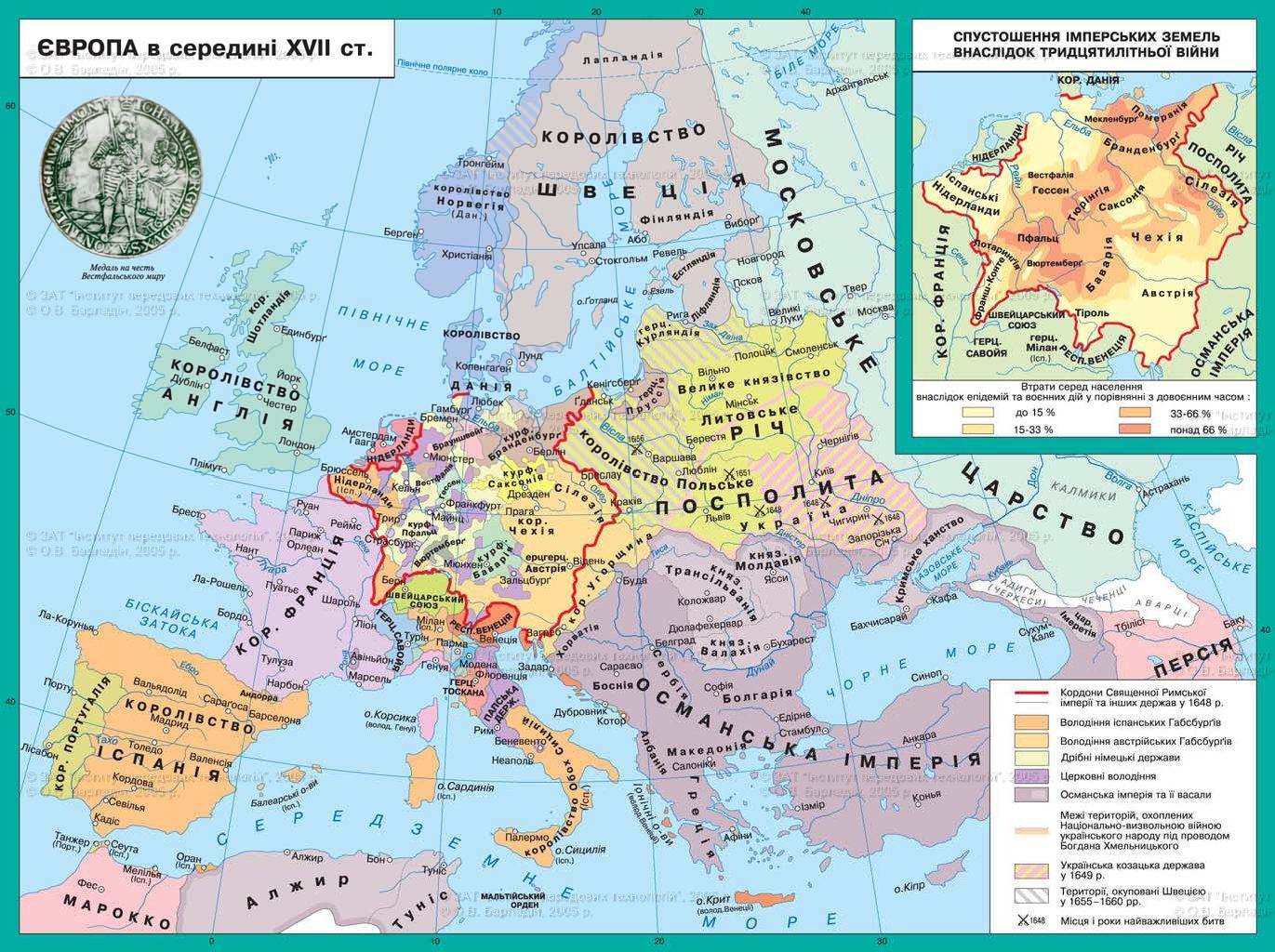
The Ukrainian map of 17th century Europe provides a rich and intricate view of a tumultuous period in European history, marked by the Deluge, the establishment of the Hetmanate, and the Thirty Years' War. This visual representation captures not just the geographical boundaries of the time, but also the socio-political dynamics that defined this era. The map illustrates the territories involved, the shifting borders, and the significant events that shaped the lives of people across Europe during this century.
Deep Dive into the Historical Context
The 17th century was a time of significant upheaval in Europe, particularly in Eastern Europe, where the Ukrainian Hetmanate emerged as a significant political entity. This region, primarily inhabited by the Cossacks, became a focal point of power struggles between neighboring states, including Poland, Russia, and the Ottoman Empire. The term "Deluge" refers to a series of wars and invasions that devastated Poland-Lithuania and Ukraine, particularly during the mid-17th century.
Interestingly, the Deluge (or "Potop" in Polish) involved a series of conflicts from 1655 to 1660, resulting in widespread destruction and a massive loss of life. The map highlights key battles and territorial changes that occurred during this period. Notably, the Cossack uprising led by Bohdan Khmelnytsky in 1648 marked the beginning of a significant shift in power dynamics, ultimately leading to the establishment of the Cossack Hetmanate in 1667.
The Thirty Years' War (1618-1648), although primarily centered in the Holy Roman Empire, also had ripple effects across Europe, impacting regions far beyond its immediate borders. The war, fueled by religious and political tensions, saw various powers, including Sweden and France, vying for dominance. The implications of this conflict extended into Ukraine as well, as different factions sought to exploit the chaos.
As we explore the map, we can observe the regions that were heavily influenced by these events. For instance, the territory of modern-day Ukraine is depicted with borders that reflect the shifting allegiances and territorial claims during this period. The map also illustrates the routes taken by invading armies, highlighting the strategic importance of Ukrainian lands as a corridor between East and West.
Regional Analysis
When examining the map, we can break down the regions it covers to understand the distinct impacts of the Deluge and the Thirty Years' War. In the northwest, Poland-Lithuania suffered immensely during the Deluge, with cities such as Warsaw and Kraków bearing the brunt of invasions. The aftermath left these cities devastated, leading to significant demographic shifts as populations fled to avoid conflict.
Meanwhile, in the east, the rise of the Hetmanate marked a new beginning for Ukrainian Cossacks. The map illustrates the borders of the Hetmanate, which expanded and contracted over the years, showcasing the fluid nature of political boundaries during this era. The Cossacks, known for their military prowess, played a crucial role in defending their lands against external threats and asserting their autonomy.
Interestingly, the division of Ukraine between Poland and Russia, as indicated on the map, set the stage for future conflicts that would continue to influence the region for centuries. The map also reveals the Ottoman Empire's influence in the south, where their territories bordered the Cossack lands. This proximity led to numerous skirmishes and alliances that further complicated the geopolitical landscape.
Significance and Impact
Understanding the historical context of the 17th century, as represented in this map, is crucial for grasping the contemporary political landscape of Eastern Europe. The conflicts of this era laid the groundwork for national identities and territorial boundaries that still resonate today. For instance, the legacy of the Hetmanate continues to influence Ukrainian nationalism and its struggle for independence in the modern era.
Moreover, the Thirty Years' War highlighted the destructive potential of religious and political conflict, a lesson that remains relevant in today's geopolitics. Ever wondered why certain regions are still fraught with tension? The historical roots can often be traced back to the conflicts illustrated in maps like this one.
In conclusion, this Ukrainian map of 17th century Europe is more than a mere representation of geographical boundaries; it serves as a narrative of human struggle, resilience, and the ongoing quest for autonomy. As we reflect on these events, we gain a deeper appreciation for the complexities of our world and the historical paths that have shaped it.
Visualization Details
- Published
- September 10, 2025
- Views
- 74
Comments
Loading comments...