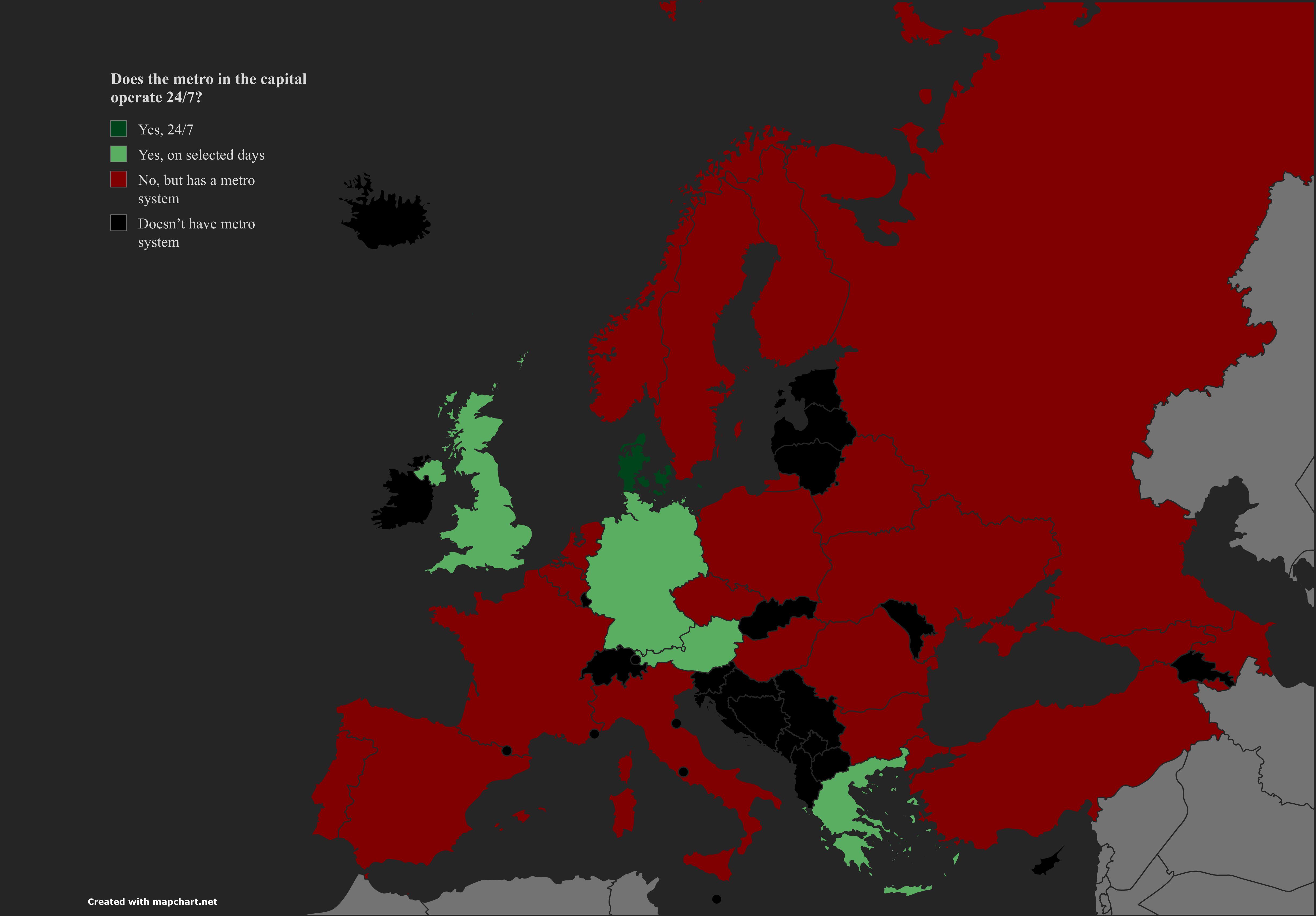
Metro Service in European Capitals Map


Marcus Rodriguez
Historical Geography Expert
Marcus Rodriguez specializes in historical cartography and geographic data analysis. With a background in both history and geography, he brings unique...
Geographic Analysis
What This Map Shows
The "Metro Service in European Capitals" map presents a comprehensive overview of the metro systems operational in various capitals across Europe. It highlights the extensive networks that facilitate urban mobility, showcasing the reach and efficiency of public transportation in some of the continent's most populated cities. As we delve deeper, we will explore the significance of these metro systems, their development, and how they shape the urban landscape.
Deep Dive into Metro Systems in Europe
Metro systems, commonly referred to as undergrounds or subways, are vital for urban transportation, especially in densely populated cities. They provide a fast and efficient means of travel, reducing congestion on the roads and minimizing the environmental impact of urban commuting. Interestingly, the development of metro systems in Europe began in the late 19th century, with London setting the stage for others to follow.
Today, cities like Paris, Berlin, and Madrid boast some of the most extensive metro networks in the world. For instance, the Paris Métro not only serves millions of passengers annually but also features 16 lines that span over 214 kilometers. Similarly, the Berlin U-Bahn encompasses 10 lines, extending over 146 kilometers, showcasing the significance of these networks in daily urban life.
What’s fascinating is that these metro systems are not just about transportation; they also reflect the cities' cultures, histories, and architectural styles. The Moscow Metro, for example, is famous for its ornate stations, often described as underground palaces. Each station tells a story, showcasing the artistic and architectural prowess of its time.
Moreover, metro systems greatly influence urban planning and development. Cities with well-established metro networks tend to experience higher levels of urban density, as these systems make it easier to commute from suburban areas. This phenomenon is evident in cities like Vienna and Stockholm, where metro accessibility has led to the development of vibrant neighborhoods and commercial hubs.
Regional Analysis
When analyzing the metro services across Europe, distinct regional patterns emerge. Western Europe, home to some of the oldest and most developed metro systems, includes cities like London, Paris, and Berlin. Each of these metros has a unique character and operational style. For instance, London’s Underground is known for its iconic map designed by Harry Beck, while the Paris Métro is famous for its Art Nouveau entrances.
In Central and Eastern Europe, cities like Budapest and Warsaw are making significant strides in improving their metro services. Budapest's Metro Line 1 is not only one of the oldest in the world, but it also serves as a UNESCO World Heritage site, emphasizing the blend of history and modernity in transportation.
Additionally, the map highlights cities that are in the early stages of metro development, such as Sofia and Bucharest. Interestingly, these cities are investing heavily in expanding their metro lines to alleviate traffic congestion and promote sustainable urban growth. As urban populations continue to rise, the demand for efficient public transport solutions becomes even more critical.
Significance and Impact
The significance of metro systems extends beyond mere transportation; they play a crucial role in addressing urban challenges. With increasing concerns about air pollution and traffic congestion, developing efficient metro networks serves as a proactive approach to creating sustainable cities. The European Union itself emphasizes sustainable urban mobility, urging member states to invest in public transportation solutions.
Current trends indicate a growing commitment to expanding and modernizing metro systems across Europe. Many cities are implementing new technologies, such as contactless payment systems and real-time tracking apps, to enhance user experience. Moreover, as cities strive to meet climate goals, metro systems are becoming a critical component of urban planning strategies.
In the coming years, we may see an even greater emphasis on integrating metro networks with other forms of public transit, such as trams and buses, to create seamless travel experiences. Have you noticed how interconnected transport systems can significantly improve city life? As we look ahead, the role of metro systems in shaping urban landscapes will undoubtedly continue to evolve, reflecting the dynamic nature of European cities.
Visualization Details
- Published
- September 10, 2025
- Views
- 66
Comments
Loading comments...