Political Map of Europe in 1812

Alex Cartwright
Senior Cartographer & GIS Specialist
Alex Cartwright is a renowned cartographer and geographic information systems specialist with over 15 years of experience in spatial analysis and data...
Geographic Analysis
What This Map Shows
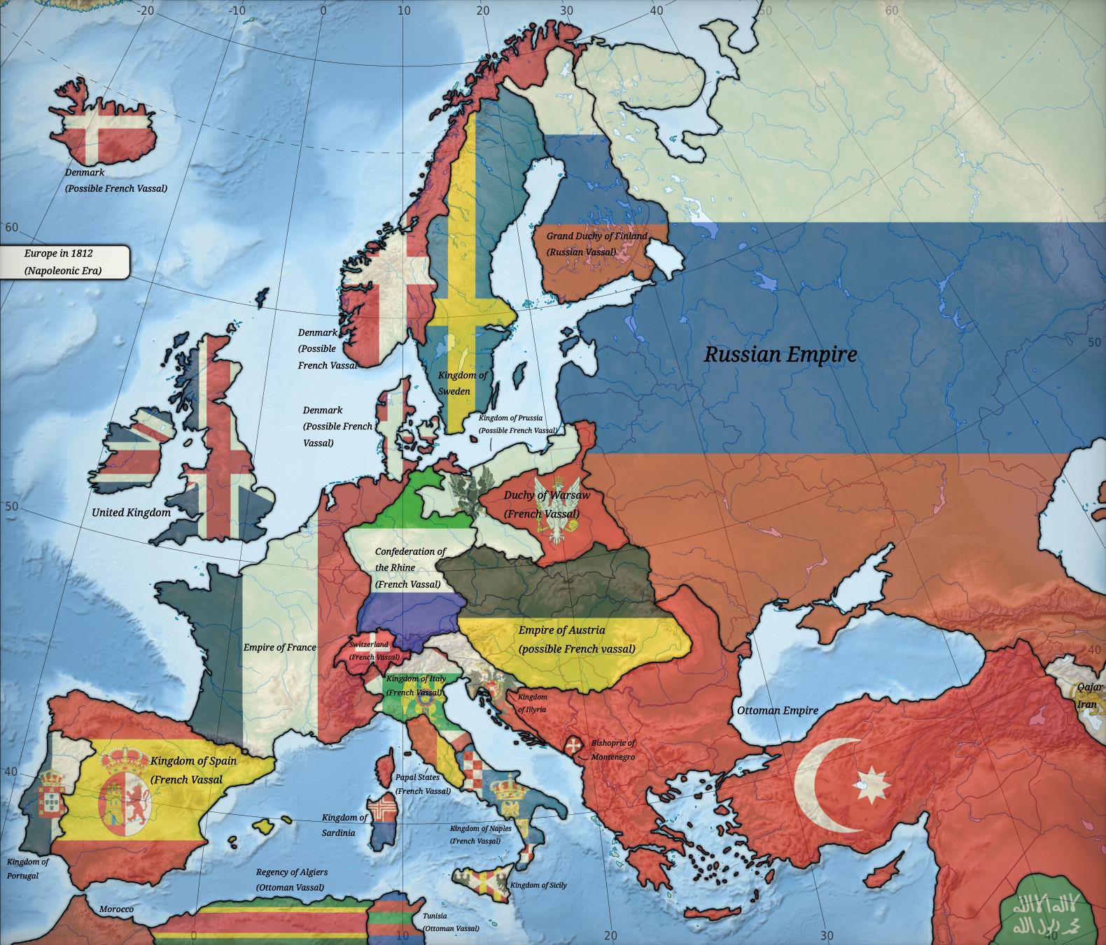
The map titled "Europe in 1812" provides a detailed political landscape of Europe during a pivotal moment in history. It illustrates the territorial boundaries, key political entities, and the various empires that dominated the continent at the start of the 19th century. This visualization is crucial for understanding the geopolitical dynamics of the time, particularly in relation to the Napoleonic Wars, which were reshaping national borders and influencing international relations across Europe.
Deep Dive into Political Changes in Europe
In 1812, Europe was undergoing significant transformations, largely instigated by the rise of Napoleon Bonaparte. The map showcases the vast French Empire, which had expanded dramatically since the late 18th century. At its zenith, the French Empire included much of Western and Central Europe, reflecting Napoleon's ambition and military prowess. Interestingly, this expansion brought about a wave of nationalism and the desire for autonomy among various ethnic groups and regions.
The political landscape was fragmented, with large empires such as the Russian Empire in the east, the Austrian Empire in the south, and the British Empire across the sea. These empires were often engaged in complex alliances and rivalries. For instance, the Treaty of Tilsit in 1807 had temporarily aligned France with Russia, but this cooperation was fragile and would soon dissolve, leading to conflicts that would reshape the map once again.
One notable aspect of the map is the presence of smaller countries and principalities, such as the Kingdom of Bavaria and the Duchy of Warsaw, which were often caught in the power struggles between the larger nations. The shifting borders indicated on the map are a testament to the ongoing conflicts and negotiations characterizing this era. For example, the Congress of Vienna, which would follow the Napoleonic Wars, sought to restore stability and redraw the boundaries once peace was achieved, highlighting the importance of this period in setting the stage for modern European politics.
Regional Analysis
Looking more closely at the regions displayed on the map, we can see distinct political climates and tensions. In Western Europe, the map highlights France, which not only held extensive territories but also had a profound influence on neighboring countries, such as the Netherlands and parts of Italy. The French Revolution's ideals of liberty and equality were seeping into these regions, leading to a rise in revolutionary sentiments.
In Central Europe, the Holy Roman Empire was in a state of decline, with Prussia and Austria emerging as significant powers. The fragmented nature of German states was a precursor to the later unification movements that would reshape the region in the latter half of the 19th century. Each region had its own unique challenges, contributing to a complex tapestry of alliances and hostilities.
Moving eastward, the Russian Empire presented a stark contrast, marked by its vastness and diversity. The map shows its extensive territory, including regions that would later become key components of modern Eastern Europe and Central Asia. The ambitions of Tsar Alexander I were evident, as he sought to expand Russian influence, particularly in the Balkans and towards the Ottoman Empire. The map thus reflects the intricate balance of power that was constantly in flux, with various nations vying for dominance or autonomy.
Significance and Impact
Understanding the political map of Europe in 1812 is crucial for grasping the subsequent historical developments that shaped the continent. This period set the stage for the rise of nationalism, the decline of empires, and the eventual emergence of nation-states. Moreover, the geopolitical tensions that surfaced during this time have had lasting effects on European and global politics.
What's fascinating is how the borders established or altered during this period influenced later events, including both World Wars. The concept of self-determination that gained traction after the Napoleonic Wars would come to define much of the 20th century, sparking movements for independence and national unity across various regions.
In today's context, the historical landscape illustrated by the map remains relevant. As Europe continues to navigate complex issues related to national identity, immigration, and political unity, the lessons learned from the past are invaluable. The ramifications of decisions made in 1812 still echo through modern political discourse, reminding us that geography and history are deeply intertwined.
This map is not just a representation of land and borders; it symbolizes the shifting tides of power, identity, and the quest for autonomy that continue to define Europe today.
Visualization Details
- Published
- September 9, 2025
- Views
- 116
Comments
Loading comments...