Historical Map of Albania 1939 to 1944

Alex Cartwright
Senior Cartographer & GIS Specialist
Alex Cartwright is a renowned cartographer and geographic information systems specialist with over 15 years of experience in spatial analysis and data...
Geographic Analysis
What This Map Shows
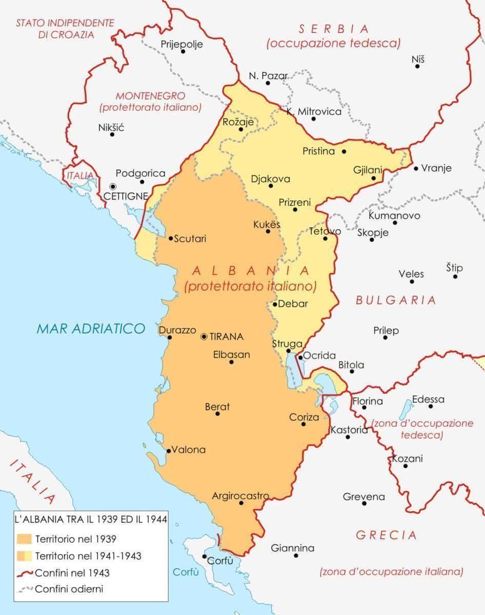
The map titled "Albania Between 1939 and 1944" provides a detailed visualization of Albania's geographical and political landscape during a tumultuous period marked by World War II. This period saw significant changes in territorial boundaries, population movements, and political governance. The map highlights not only the physical geography of Albania but also the shifts in control and influence exerted by various powers, including Italy and Germany, as well as the local resistance movements.
Deep Dive into Albania's History During 1939-1944
Albania's history between 1939 and 1944 is deeply intertwined with the larger narrative of World War II. In April 1939, Albania was invaded by Italy, marking the beginning of a tumultuous period. This invasion was largely motivated by Italy's Fascist regime under Benito Mussolini, who sought to expand Italy's territory and influence in the Balkans. It is intriguing to note that Albania was not just a target of aggression but also a strategic point for Italian control over the Adriatic Sea.
The Italian occupation brought significant changes to Albania’s political structure. The map illustrates how the country was divided into various administrative regions under Italian control, with a focus on the establishment of military bases and strategic locations. The central and southern regions, including the capital, Tirana, were heavily fortified, reflecting Italy's military objectives.
As the war progressed, the dynamics shifted dramatically. With the onset of the German invasion in 1943, Albania's political landscape became even more complex. Germany took over the Italian positions, leading to further changes in governance and military control. The map serves as a testament to these shifting powers, showcasing the regions that were under the control of different military forces throughout this period.
Interestingly, while the map highlights military control, it also hints at the burgeoning resistance movements within Albania. Groups such as the National Liberation Movement began to emerge, rallying support against both Italian and German forces. This internal struggle for autonomy and freedom is a crucial aspect of Albania's history during these years, reflecting the resilience of the Albanian people despite the oppressive regimes.
Regional Analysis
When examining the map closely, one can discern significant regional differences in terms of control and resistance. For instance, the northern regions of Albania, such as Shkodra and Kukës, experienced a different kind of occupation compared to the southern areas like Vlorë and Saranda. The northern regions were more influenced by local tribes and had a strong historical connection to resistance against foreign domination. In contrast, the south, being closer to Italy, faced earlier and more direct Italian military presence.
Moreover, the urban centers, particularly Tirana and Durrës, were focal points for the Italian military and administrative efforts. This led to an influx of Italian settlers and a transformation of urban landscapes, which is evident in the infrastructure developments that took place during this period. The map vividly illustrates these urban centers, showing where the effects of occupation were most pronounced.
Significance and Impact
Understanding the geographical and political shifts in Albania from 1939 to 1944 is vital for several reasons. First, it sheds light on the broader implications of World War II in the Balkans, highlighting how the war reshaped national identities and borders that would last long after the conflict ended. The repercussions of this period are still felt today, as Albania navigates its path in the modern geopolitical landscape of Southeast Europe.
Furthermore, the map is a reminder of the resilience of nations facing foreign domination. The story of Albania during these years is not just one of oppression but also of resistance and the fight for autonomy. As we reflect on this historical period, it raises questions about the nature of sovereignty and the lengths to which people will go to protect their identity and homeland.
In conclusion, the historical map of Albania from 1939 to 1944 provides a window into a critical period marked by conflict and change. It serves not only as a record of territorial shifts and military strategies but also as a testament to the enduring spirit of the Albanian people amidst adversity. Ever wondered how these historical events have shaped the contemporary landscape of Albania? The answers lie within the layers of history that this map encapsulates.
Visualization Details
- Published
- September 7, 2025
- Views
- 88
Comments
Loading comments...