Deadliest Earthquakes of the 21st Century Map

David Chen
Data Visualization Specialist
David Chen is an expert in transforming complex geographic datasets into compelling visual narratives. He combines his background in computer science ...
Geographic Analysis
What This Map Shows
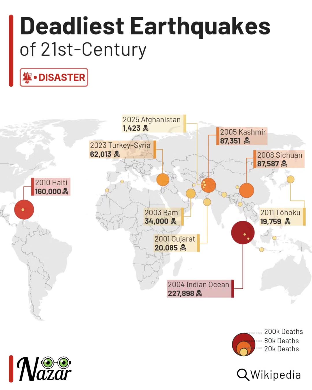
The "Deadliest Earthquakes of the 21st Century" map offers a stark visual representation of the most catastrophic seismic events that have occurred since the turn of the millennium. Each point on the map indicates the location of a major earthquake, accompanied by details such as the magnitude, date, and the resultant death toll. This visualization serves as a powerful reminder of the destructive potential of natural disasters and the vulnerability of various regions around the globe to seismic activity.
Earthquakes can occur with little warning, and their impacts can be devastating, affecting not just the immediate area but also leading to far-reaching consequences in terms of infrastructure, economy, and human lives. Understanding the geographical distribution of these seismic events helps us grasp the patterns and vulnerabilities associated with earthquake-prone regions.
Deep Dive into Earthquakes
Earthquakes are the result of sudden movements of the Earth's tectonic plates. Interestingly, the Earth's crust is divided into several large and small plates that float on the semi-fluid mantle beneath them. These plates constantly move, albeit very slowly, leading to stress accumulation at their boundaries. When the stress exceeds the strength of rocks, they break, resulting in an earthquake.
The magnitude of an earthquake is measured on the Richter scale or the moment magnitude scale (Mw), which quantifies the energy released during the event. For instance, the 2010 Haiti earthquake, which registered a magnitude of 7.0, resulted in over 200,000 fatalities, making it one of the deadliest in recorded history. On the other hand, the 2004 Indian Ocean earthquake and tsunami, with a magnitude of 9.1-9.3, caused massive devastation across several countries and led to more than 230,000 deaths across 14 nations.
What’s fascinating is that not all earthquakes lead to tsunamis, but when they occur under the ocean or near coastlines, the risk increases drastically. Regions along the Pacific Ring of Fire are particularly susceptible to such disasters due to their location near tectonic plate boundaries. This area is known for its seismic activity, and countries like Japan, Indonesia, and Chile frequently experience powerful quakes.
In terms of frequency, earthquakes are common across the globe, but their deadliness often correlates with population density and building practices. A low-magnitude earthquake in a densely populated urban area can result in catastrophic consequences, while a high-magnitude quake in a sparsely populated region might lead to minimal damage. For instance, the 2015 Nepal earthquake, with a magnitude of 7.8, devastated the capital city of Kathmandu and surrounding areas, causing over 9,000 deaths. This highlights the importance of preparedness and infrastructure resilience in mitigating the impacts of such natural disasters.
Regional Analysis
Looking at the map, one can discern distinct patterns in earthquake occurrences across different regions. For example, regions like South Asia, particularly India and Nepal, experience frequent seismic activity due to the collision of the Indian and Eurasian tectonic plates. This has resulted in a history of significant earthquakes, including the devastating 2001 Gujarat earthquake.
In contrast, the western coast of the United States, particularly California, is another hotspot due to the San Andreas Fault, which is a well-known transform boundary between the Pacific and North American plates. The 1994 Northridge earthquake in California, while technically occurring just before the 21st century, still serves as a relevant example of how even developed infrastructure can be susceptible to severe earthquakes.
Interestingly, while countries like Japan and Indonesia face severe risks due to their geographic positions, advanced engineering and preparedness strategies have significantly helped reduce fatalities. Japan's stringent building codes and early warning systems are prime examples of how preparedness can mitigate the impacts of such devastating events.
Conversely, countries with less developed infrastructure often suffer disproportionately high casualty rates during earthquakes. The 2010 Haiti earthquake starkly illustrates this point, where inadequate building standards and emergency response capabilities led to catastrophic loss of life.
Significance and Impact
Understanding the implications of earthquakes is crucial for many reasons. For one, it underscores the importance of disaster preparedness and the need for comprehensive urban planning that considers seismic risks. Countries with a history of seismic activity must invest in resilient infrastructure and public education to minimize casualties during such disasters.
Moreover, as urban populations continue to swell, the stakes become even higher. Ever wondered why cities in earthquake-prone regions often face greater risks? It’s due to the combination of increased density and often outdated infrastructure that cannot withstand significant seismic events.
Looking ahead, one can see that climate change may also play a role in changing seismic patterns, as melting glaciers and shifting tectonic stress could potentially lead to increased seismic activity in certain areas. Therefore, ongoing research and monitoring of seismic activity is crucial.
In conclusion, the "Deadliest Earthquakes of the 21st Century" map not only provides a visual representation of these tragic events but also serves as a call to action for governments and communities to prioritize earthquake preparedness and resilience.
Whether through better building standards, community education, or international cooperation in disaster response, the implications of understanding earthquake risks are profound and necessary for safeguarding lives.
Visualization Details
- Published
- September 5, 2025
- Views
- 64
Comments
Loading comments...