The Maghreb Map in the Year 1880

Alex Cartwright
Senior Cartographer & GIS Specialist
Alex Cartwright is a renowned cartographer and geographic information systems specialist with over 15 years of experience in spatial analysis and data...
Geographic Analysis
What This Map Shows
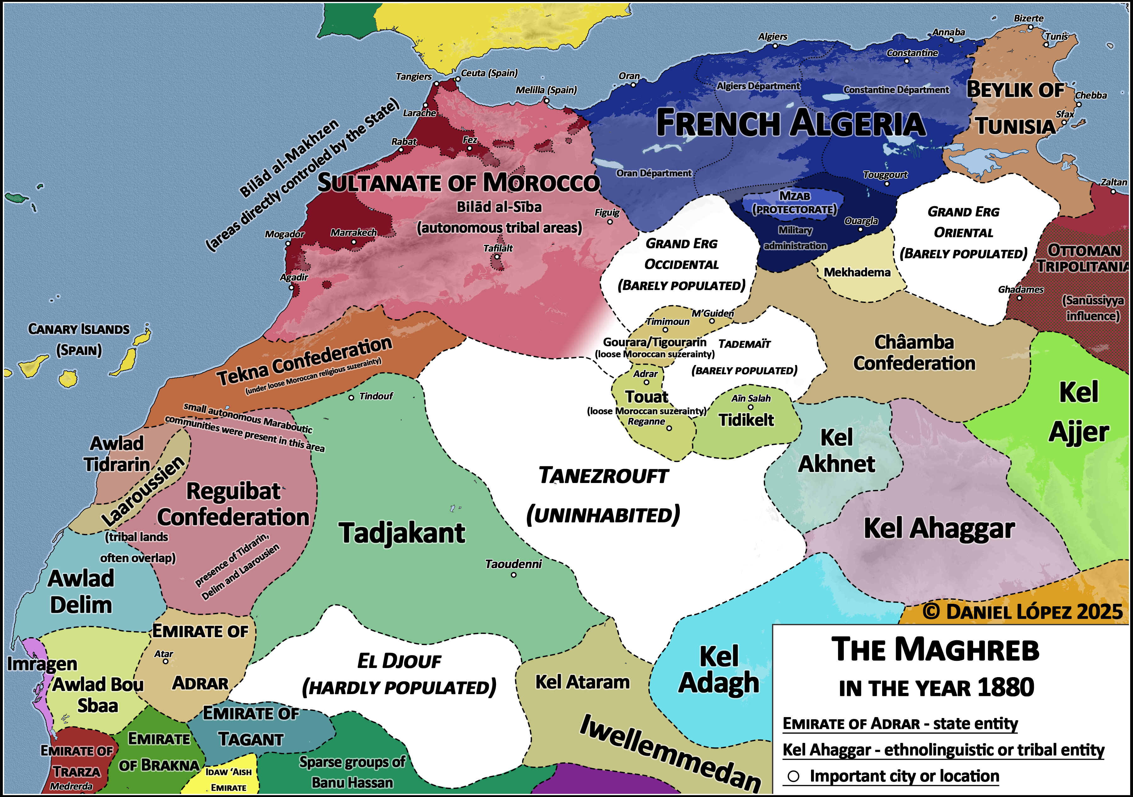
This map of the Maghreb region in the year 1880 provides a compelling visual representation of North Africa during a time of significant political and social change. The Maghreb, comprising modern-day Morocco, Algeria, Tunisia, and Libya, was characterized by a rich tapestry of cultures, economies, and landscapes. The map highlights not only territorial boundaries but also the various colonial influences that were beginning to take root in the region, particularly from European powers such as France and Spain. This visual snapshot enables us to better understand the historical context and the geopolitical dynamics at play during the late 19th century.
Deep Dive into Colonial Influences and Socio-Economic Structures
The late 19th century was a pivotal moment for the Maghreb, as colonial ambitions from European powers intensified. Interestingly, by 1880, France had already begun its military campaigns in Algeria, which had been under French control since 1830. The map reveals the territorial divisions and administrative regions established by the French, which would profoundly impact the socio-economic structures of the area.
Morocco, while remaining largely independent, was under increasing pressure from European nations, particularly Spain and France, which were vying for influence. Have you ever wondered how these colonial pressures shaped local governance and trade? In this period, the traditional systems of governance in these regions were often undermined or altered to suit colonial interests. Local leaders found themselves navigating a complex landscape of external pressures and internal dynamics.
Economically, the Maghreb was a region of agricultural richness and strategic trade routes. The Mediterranean Sea facilitated trade with Europe, while the Sahara connected sub-Saharan Africa with the Mediterranean and European markets. The map illustrates vital trade routes, highlighting the significance of cities such as Tangier, Algiers, and Tunis as commercial hubs. Additionally, the fertile plains of the Tell region in Algeria and Tunisia were crucial for agricultural production, primarily grain and olive oil, which were highly sought after in European markets.
Regional Analysis
When breaking down the Maghreb region by its constituent areas, we find distinct characteristics that defined each territory. Morocco, for instance, remained a kingdom with a robust cultural identity, evident in the preservation of its indigenous Berber and Arab traditions. However, the pressure from European powers led to the signing of treaties that eroded its sovereignty, which would culminate in the establishment of the French and Spanish protectorates in the early 20th century.
Algeria, on the other hand, was directly under French rule by 1880, which significantly altered its demographic and cultural landscape. The French settlers, known as pieds-noirs, began to appropriate fertile lands, displacing local populations and altering traditional farming practices. The map indicates the spread of European settlements and infrastructure, showcasing how colonialism reshaped the territory.
Tunisia, while also under French influence, maintained a degree of autonomy until a full protectorate was established in 1881. The map provides insight into the administrative districts that were established during this time, indicating how European powers sought to control governance and resources. Libya, at this time, was still largely under the Ottoman Empire, but colonial interests from Italy began to emerge, marking the beginning of a struggle for control that would escalate in the following decades.
Significance and Impact
Understanding the Maghreb in 1880 is critical for grasping the roots of modern political and social dynamics in North Africa. The colonial policies enacted during this period have had lasting impacts, influencing not only national boundaries but also cultural identities and economic structures. The legacy of colonialism continues to be felt today, as nations grapple with the consequences of past foreign interventions and the struggle for independence.
What's fascinating is that the geopolitical tensions present in the 1880s have echoes in contemporary issues, such as migration patterns, economic disparities, and political unrest. As we analyze current trends, it’s essential to recognize how historical contexts shape present-day realities. The Maghreb's transition from a region of rich indigenous cultures to one heavily influenced by colonialism has had profound implications for its development and continues to inform its future trajectory. As we look ahead, understanding these historical frameworks can provide valuable insights into the complexities of North African politics and society today.
Visualization Details
- Published
- September 5, 2025
- Views
- 94
Comments
Loading comments...