Modern Day Pangea Map with Current Borders

David Chen
Data Visualization Specialist
David Chen is an expert in transforming complex geographic datasets into compelling visual narratives. He combines his background in computer science ...
Geographic Analysis
What This Map Shows
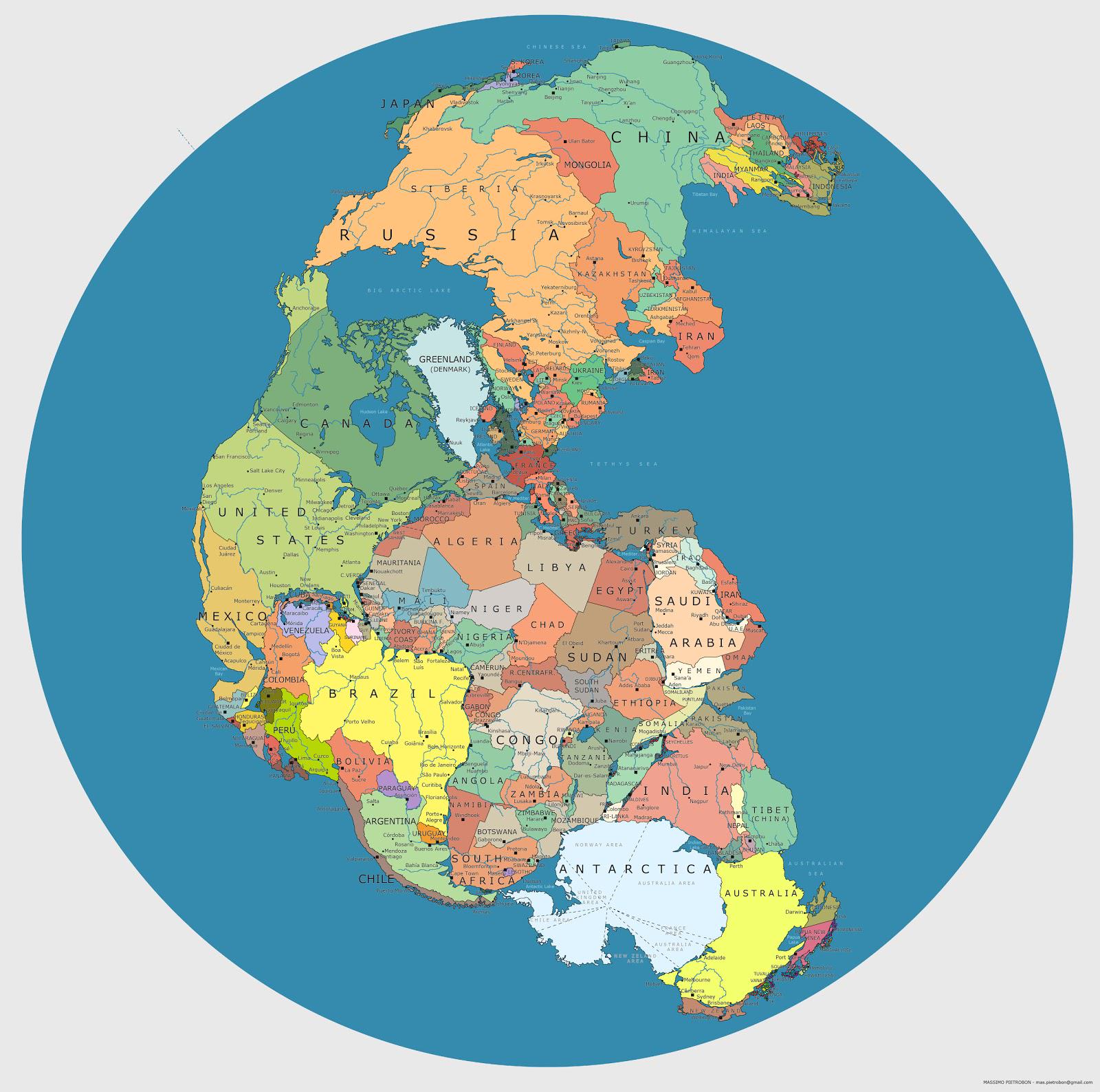
The "Modern Day Pangea" map is an incredible visualization that reimagines the supercontinent Pangea as it would appear in today's geopolitical landscape, overlaying modern national borders onto the ancient landmass. Pangea, which existed approximately 335 million years ago, was a colossal landmass that eventually broke apart, leading to the formation of our current continents. This map provides a striking visual contrast between the geological past and the present, highlighting how the earth’s tectonic movements have shaped the world we know today.
However, this isn't just a fascinating visual exercise; it also prompts us to consider the implications of continental drift, the movement of tectonic plates, and how these processes affect our planet’s geography.
Deep Dive into Continental Drift and Tectonic Activity
Continental drift is a fundamental geological theory that describes how continents move over geological time due to the activity of tectonic plates. The earth's lithosphere (the outer shell) is divided into several plates that float on the semi-fluid asthenosphere beneath. Interestingly, these plates are constantly in motion, albeit at a slow pace of about 2 to 5 centimeters per year.
The breakup of Pangea, which occurred during the Jurassic period, was primarily driven by the movements of these tectonic plates. As the plates separated, distinct geological features began to form. For example, the Mid-Atlantic Ridge emerged as the North American and Eurasian plates drifted apart, creating new oceanic crust.
What's fascinating is how this ancient split continues to influence modern geological activity. The boundaries of tectonic plates are often the sites of earthquakes, volcanic eruptions, and mountain formation. For instance, the Pacific Ring of Fire is an area with high seismic activity, largely due to the movements of the Pacific Plate.
Moreover, the redistribution of landmasses has significant implications for biodiversity. As continents separated, species evolved in isolation, leading to the rich variety of flora and fauna we see today. For instance, the unique wildlife of Australia developed largely because it became isolated from other landmasses.
Statistics reveal that nearly 75% of the earth’s surface is covered by water, and the arrangement of continents affects global climate patterns. Ocean currents, formed largely due to the positioning of continents, play a crucial role in regulating temperatures and weather systems around the globe.
Regional Analysis
When we look at the map of Modern Day Pangea, we can see how various regions would align if they were part of a single landmass. For example, the eastern coast of South America aligns closely with the western coast of Africa, which is a clear indication of their shared geological history.
In North America, states like Florida would sit adjacent to parts of Europe, such as the Iberian Peninsula, illustrating how the Atlantic Ocean's formation altered the landscape. The Himalayas, a region formed from the collision of the Indian and Eurasian plates, would also be prominent in this reimagined landmass, showcasing the dynamic nature of plate tectonics.
Comparatively, regions like Madagascar, isolated from mainland Africa, highlight how the drift has influenced not just geography but also ecosystems. Madagascar is home to many unique species that evolved independently after it separated from the African continent around 160 million years ago.
Significance and Impact
Understanding the concept of continental drift and the visualization of Modern Day Pangea is crucial for several reasons. It helps us comprehend the geological processes that shape our planet and the historical context behind current land formations. Moreover, recognizing how these processes affect climate patterns, biodiversity, and even human civilization is vital in today’s context.
For instance, as climate change accelerates, the shifting of tectonic plates may also lead to new geological formations, affecting sea levels and weather patterns further. Additionally, the understanding of tectonic activity is essential for disaster preparedness, particularly in regions prone to earthquakes and volcanic eruptions.
In conclusion, the Modern Day Pangea map is more than just a visualization; it is a reminder of the dynamic and ever-changing nature of our planet. It encourages us to think critically about the past, present, and future of the earth's geography and the intricate connections between its various regions.
Whether you're a geography enthusiast or simply curious about the world, this map opens up a dialogue about our planet's history and its ongoing transformation.
Visualization Details
- Published
- September 4, 2025
- Views
- 82
Comments
Loading comments...