
David Chen
Data Visualization Specialist
David Chen is an expert in transforming complex geographic datasets into compelling visual narratives. He combines his background in computer science ...
Geographic Analysis
What This Map Shows
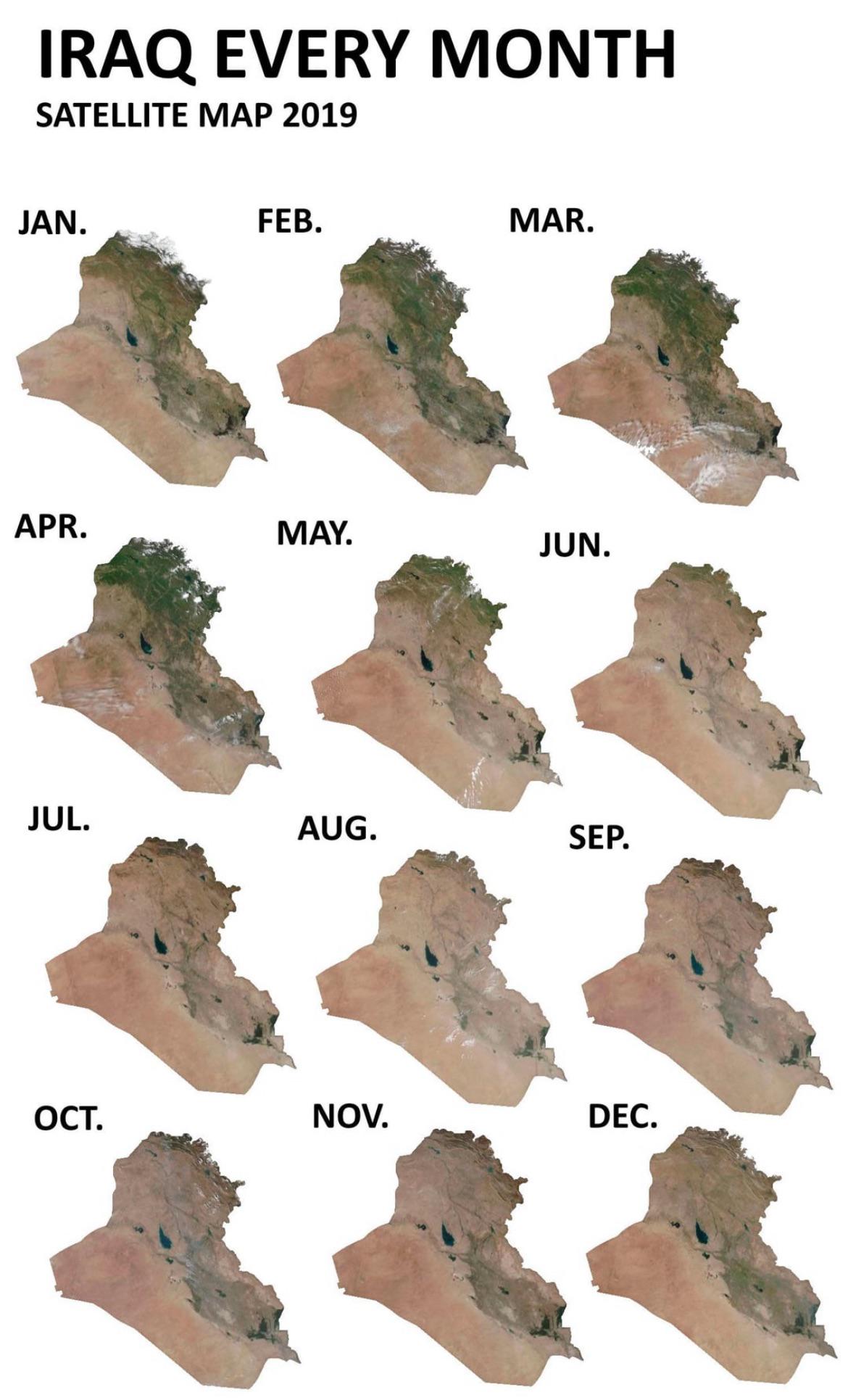
This map visualizes how Iraq’s greenery fluctuates throughout the seasons, particularly focusing on satellite imagery captured by NASA in 2019. The visualization highlights the stark contrast in vegetation cover during different months of the year, showcasing how the steppe regions of Iraq transform from barren land to lush greenery in the first part of the year. As temperatures shift dramatically between winter and summer, this map serves as a compelling illustration of the relationship between climate and vegetation in Iraq.
Deep Dive into Iraq's Seasonal Greenery
Iraq's steppe regions are characterized by their unique climatic conditions that significantly influence their greenery. During the first four to five months of the year, specifically from January to May, Iraq experiences milder temperatures, which are conducive to the growth of vegetation. These months are marked by moderate weather, with average temperatures that allow for the germination and growth of various plant species.
Interestingly, the temperature in Iraq can vary drastically between winter and summer, with differences reaching up to 40-50 degrees Celsius, particularly in areas of varying elevation. The winter months, while relatively cool, provide necessary moisture through rain, creating an optimal environment for the seeds lying dormant in the soil. As spring approaches, the increased temperatures combined with the moisture lead to a remarkable transformation where the barren steppe transitions into a vibrant green landscape.
During these months, you might notice wildflowers blooming across the steppe, along with grasses that thrive in the cooler temperatures. This seasonal burst of greenery is essential not just for the local ecosystem but also for the agriculture that many communities rely upon.
Moreover, what’s fascinating is that this seasonal shift doesn’t just impact flora; it also affects fauna. As the vegetation flourishes, it attracts various migratory birds and other wildlife, creating a lively ecological tapestry. The presence of greenery during this period provides crucial habitats for these species, underlining the interconnectedness of climate and biodiversity.
Regional Analysis
Breaking down the map by region, we find significant variations in greenery across different parts of Iraq. For instance, southern Iraq, which typically experiences hotter temperatures, sees a more pronounced green-up in the early months of the year compared to the northern regions. In the north, areas such as the Kurdistan region may retain some greenery into the summer due to their higher elevation and cooler climates, while the southern regions may quickly dry out by June.
In Baghdad and its surrounding areas, the seasonal transition is quite dramatic. The map reveals how the Tigris River's proximity influences local vegetation, as the river provides necessary irrigation during the dry summer months. On the contrary, desert areas such as Al-Najaf and Al-Qadisiyyah may experience a limited green period, as the extreme heat in summer can lead to rapid desiccation of plants.
This geographical contrast is essential in understanding regional agricultural practices. Farmers in the fertile crescent region are keenly aware of these seasonal shifts and often plan their sowing and harvesting cycles accordingly. The timing of rainfall, which peaks in the winter and early spring, is critical for crop yields, influencing everything from wheat to barley production.
Significance and Impact
Understanding how seasons affect Iraq's greenery is crucial for several reasons. Firstly, it impacts food security in a country that has faced numerous challenges over the years, including conflicts and climate change. With agriculture being a primary livelihood for many, recognizing these seasonal patterns can help in planning for sustainable farming practices.
Additionally, as climate change continues to alter weather patterns globally, monitoring how Iraq's vegetation responds to these changes is vital. Trends indicate that warmer temperatures may lead to shorter green periods, which could threaten biodiversity and food production.
Furthermore, this information is essential for policymakers who need to create effective environmental management strategies. By recognizing the importance of seasonal vegetation patterns, they can better address issues like water resource management and land use planning. The map serves as a crucial tool for visualizing the delicate balance between climate, ecology, and human activity in Iraq, emphasizing the need for thoughtful practices to protect and enhance this vital resource.
In conclusion, the transformation of Iraq's greenery throughout the seasons is not just a beautiful spectacle but also a complex interplay of climatic factors, ecological dynamics, and human dependency. By understanding and appreciating these changes, we can foster a more sustainable future for Iraq’s environment and its people.
Visualization Details
- Published
- September 3, 2025
- Views
- 72
Comments
Loading comments...