Chile and Argentina Size Comparison Map

Marcus Rodriguez
Historical Geography Expert
Marcus Rodriguez specializes in historical cartography and geographic data analysis. With a background in both history and geography, he brings unique...
Geographic Analysis
What This Map Shows
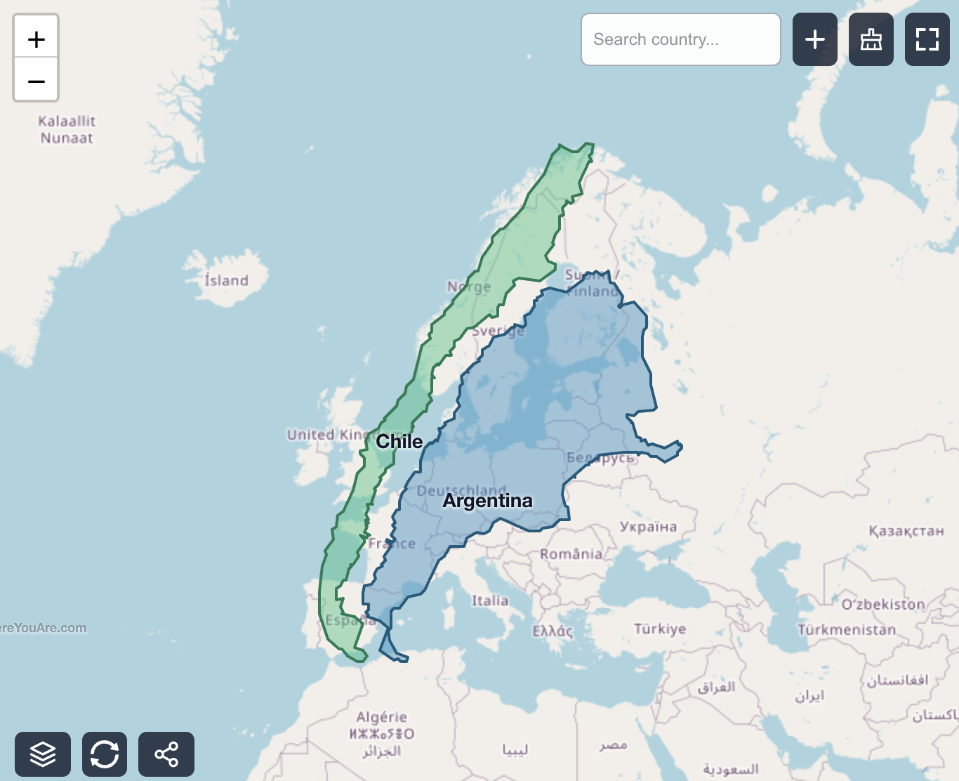
This map provides a striking visualization of the sheer size of Chile and Argentina by overlaying them onto Europe. At first glance, it’s hard to grasp the scale of these South American countries until you see them compared to a familiar continent like Europe. Chile, stretching approximately 756,102 km², occupies around 7.4% of Europe’s total area. In contrast, Argentina is a behemoth at about 2,780,400 km², covering roughly 27.3% of Europe. Together, these two countries represent about 34.7% of Europe’s landmass. This comparison not only highlights the vastness of these nations but also clarifies why traversing southern South America is no small feat.
Deep Dive into Geography of Chile and Argentina
Understanding the geography of Chile and Argentina requires more than just looking at their shapes on a map; it involves delving into their unique landscapes, climates, and ecological zones. Chile is renowned for its elongated shape, stretching about 4,270 km from north to south, making it one of the longest countries in the world. This extreme latitudinal span contributes to diverse climatic conditions. The northern regions, such as the Atacama Desert, are among the driest places on Earth, while the southern regions experience a temperate maritime climate, characterized by lush forests and abundant rainfall.
Argentina, on the other hand, showcases a remarkable variety of geographical features. The country spans several climate zones, from the subtropical north to the arid Patagonian steppe in the south. The Andes mountain range runs along the western edge of Argentina, creating a natural border with Chile and providing some of the most stunning landscapes on the continent. These mountains are not just geographical features; they are crucial for biodiversity, housing numerous endemic species and unique ecosystems.
Moreover, both countries have significant river systems that play a vital role in their geography. The Paraná and Río de la Plata are major waterways in Argentina, crucial for agriculture and trade. In Chile, the Loa River, the longest river in the country, is essential for water supply and irrigation. Interestingly, these rivers also highlight how water resources are distributed across such vast landscapes, affecting agriculture, urban development, and environmental sustainability.
Regional Analysis
Let's break down the geographical features of these two countries by region, starting with Chile. In the north, the arid desert landscapes of the Atacama contrast sharply with the fertile valleys found in the central region, where the majority of Chile's population resides. Cities like Santiago and Valparaíso are not only cultural hubs but also economic centers, benefiting from the country's diverse geography.
Moving south, the temperate rainforest region of Patagonia showcases an entirely different landscape, rich in biodiversity and natural beauty. This area is significant for conservation efforts and ecotourism, drawing visitors who seek to experience its unique ecosystems.
In Argentina, the north is predominantly agricultural, with the Gran Chaco region producing soybeans and other crops. The Pampas, known for their fertile soils, are crucial for cattle ranching and agriculture. However, as you move south towards Patagonia, the landscape transforms into a mix of mountains, glaciers, and plains, offering a stark contrast to the agricultural heartland.
Interestingly, the Pampas and the Andes illustrate the economic disparities between regions. While the northern and central areas thrive economically due to agriculture, tourism in Patagonia is vital for local economies, focusing on sustainability and conservation.
Significance and Impact
Understanding the geography of Chile and Argentina is essential for comprehending their socio-economic dynamics and environmental challenges. The vastness of these countries means that transportation and infrastructure development are significant issues. For instance, the distance between urban centers can be daunting, often leading to logistical challenges in trade and travel. Ever wondered why “just drive it” isn’t really a thing in southern South America? The sheer scale of these countries makes long-distance travel complex, and many regions remain remote.
Additionally, climate change poses serious threats to both nations. The melting glaciers in Patagonia, for example, not only impact local ecosystems but also have broader implications for sea-level rise. This underscores the need for sustainable development practices that balance economic growth with environmental stewardship.
In conclusion, the size comparison of Chile and Argentina against Europe not only provides a visual perspective but also invites us to explore the rich geographical and ecological diversity of these nations. As we continue to navigate challenges posed by climate change and urbanization, understanding the geography of these vast landscapes will be crucial for future planning and conservation efforts.
Visualization Details
- Published
- September 3, 2025
- Views
- 74
Comments
Loading comments...