Napoleon's Battles Map

Alex Cartwright
Senior Cartographer & GIS Specialist
Alex Cartwright is a renowned cartographer and geographic information systems specialist with over 15 years of experience in spatial analysis and data...
Geographic Analysis
What This Map Shows
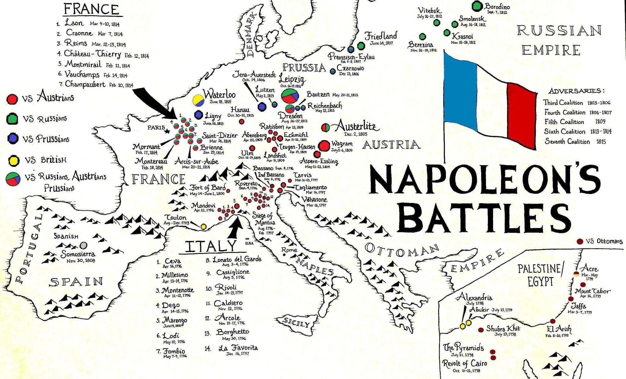
The "Napoleon's Battles Map" provides a comprehensive overview of the key military engagements led by Napoleon Bonaparte during the early 19th century. Each marked battle reveals the geographical context in which these significant historical events transpired, showcasing the locations across Europe where strategies were tested and empires were challenged. By visualizing these battles, the map not only highlights the military prowess of Napoleon but also emphasizes the political and cultural shifts that occurred as a result of his campaigns.
Deep Dive into Napoleon's Military Campaigns
Napoleon Bonaparte, a figure often synonymous with military genius, engaged in numerous battles that reshaped Europe. His campaigns spanned various terrains, from the frozen landscapes of Russia to the sun-drenched plains of Italy. One of the most pivotal aspects of these battles was the strategic use of geography. For instance, the Battle of Austerlitz in 1805, often regarded as Napoleon's greatest victory, took place on a series of rolling hills which he cleverly used to gain the upper hand against the Austro-Russian forces. This battle showcased not only his tactical acumen but also the importance of terrain in warfare.
Interestingly, Napoleon’s military campaigns were not just about brute strength; they also involved significant logistical challenges. Supply lines were critical, especially during the ill-fated Russian campaign of 1812, where harsh winter conditions and extended distances severely hampered his army’s capability. This underscores how geography can influence the outcome of military actions. The vast expanses of Russia presented not just a physical barrier but also a psychological one, leading to one of the most dramatic retreats in military history.
Another fascinating battle illustrated on the map is the Battle of Waterloo in 1815, which marked the end of Napoleon's reign. The terrain played a crucial role here as well; the muddy fields were detrimental to the movement of troops and artillery, ultimately contributing to Napoleon's defeat against the Duke of Wellington and his coalition forces. The topography of the battlefield, combined with weather conditions, can often tilt the balance in warfare—an aspect that is vividly illustrated by the outcomes of Napoleon’s battles.
Regional Analysis
When examining the map, it's evident that Napoleon's campaigns were concentrated in key regions of Europe, primarily France, Italy, and parts of Eastern Europe. In France, Napoleon utilized his knowledge of local geography to execute rapid troop movements, allowing him to outmaneuver opposition forces. The Italian Campaign (1796-1797) is a prime example, where he achieved a series of victories against Austria and its allies, leveraging the mountainous terrain to his advantage.
In contrast, the campaigns in Eastern Europe presented unique challenges. The vastness of Russia, for example, forced Napoleon to adapt his strategies significantly. The map illustrates significant battles like Borodino, which were fought over an expansive area and featured fierce engagement. The sheer scale of these battles often led to staggering casualties, with Borodino resulting in about 70,000 total casualties, a testament to the brutal realities of Napoleonic warfare.
The influence of geography can also be seen in the varied outcomes of battles across different terrains. In general, battles fought in open plains tended to favor Napoleon's aggressive tactics and rapid maneuvers, while those in more complex terrains presented greater challenges and often resulted in higher casualties.
Significance and Impact
The significance of Napoleon’s battles extends beyond mere military history; they have profound implications for our understanding of European politics and national boundaries. His campaigns led to the rise of nationalism and the re-drawing of the map of Europe, as various nations sought to assert their independence or expand their reach in response to Napoleon's conquests. Have you noticed how many modern European borders can trace their origins back to this tumultuous period?
Current geopolitical landscapes still reflect the historical shifts initiated by these battles. For instance, the impact of the Congress of Vienna in 1815, which aimed to restore stability in Europe after the Napoleonic Wars, is evident in today’s political alliances and conflicts. Furthermore, the lessons learned from Napoleon's campaigns continue to influence military strategies and geopolitical theories.
As we analyze these historical battles, it's crucial to understand their lasting legacies. The geographical insights gained from studying Napoleon's campaigns can inform modern military and political strategies, reminding us that geography is not just a backdrop but a dynamic element that shapes conflicts and resolutions. What’s fascinating is how the contours of the land can dictate the tide of history, making geography an essential aspect of understanding warfare.
So, the next time you look at the "Napoleon's Battles Map," consider not just the battles fought, but the geographical narratives that shaped them and how those narratives continue to echo in today's world.
Visualization Details
- Published
- September 1, 2025
- Views
- 92
Comments
Loading comments...