Relief Population Density Map of Iraq

David Chen
Data Visualization Specialist
David Chen is an expert in transforming complex geographic datasets into compelling visual narratives. He combines his background in computer science ...
Geographic Analysis
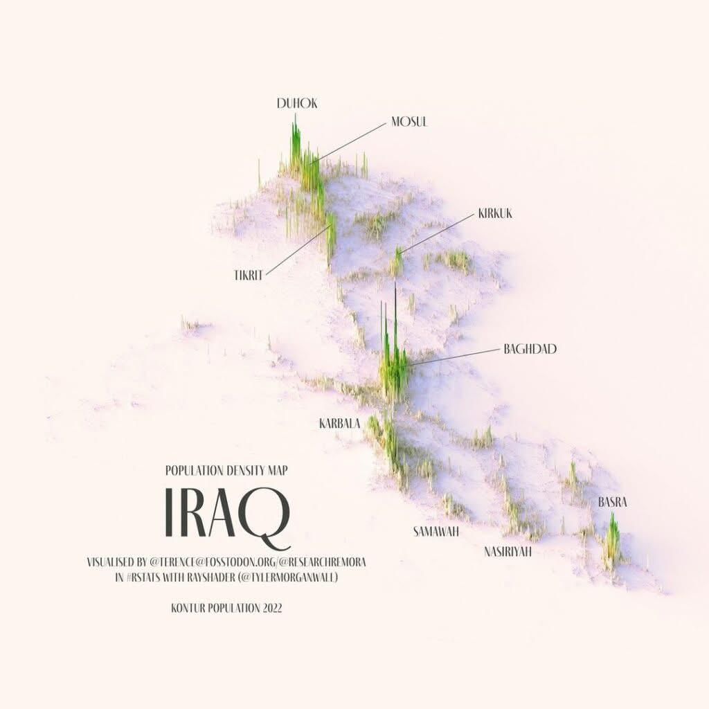
What This Map Shows\nThe Relief Population Density Map of Iraq provides a clear visualization of how the population is distributed across the country's varied terrain. The map highlights urban versus rural population concentrations, revealing significant insights into demographic trends and settlement patterns throughout Iraq. According to the February 2025 national census, a striking 70.17% of Iraq's population lives in urban areas, leaving 29.83% in rural regions. This urbanization trend is crucial for understanding how people are adapting to their environments and what this means for future development.
Deep Dive into Population Distribution\nPopulation density is an important metric that tells us not just how many people live in a given area, but also how they interact with their environment. In Iraq, the urban population is overwhelmingly concentrated in a few major cities, with over 20% of the entire population residing in the Baghdad metropolitan area alone. This figure dwarfs the combined populations of the Kurdistan region's governorates, showcasing Baghdad's role as a central hub of economic, social, and cultural activity.
Baghdad, with a population of approximately 8 million, is not just the capital but also the largest city in the country, serving as a focal point for migration and urbanization. Following Baghdad, we see Mosul (1.8 million), Basra (1.5 million), Kirkuk (1.1 million), Erbil (1 million), and Najaf (1 million). Together, these cities account for over 55% of Iraq's total population, underlining a troubling trend: the increasing strain on urban infrastructure and resources.
Interestingly, the distinct demographic patterns reflect not only the historical significance of these cities but also their economic opportunities. Baghdad's metropolitan area, for instance, is known for its diverse job market, educational institutions, and healthcare facilities, attracting individuals from rural areas seeking better livelihoods. However, this urban influx comes with challenges, including overcrowding, pollution, and increased pressure on public services.
As we look deeper into the population density figures, we see that urban areas tend to have better access to amenities such as education, healthcare, and infrastructure compared to rural locales. This disparity raises questions about how to improve living conditions in less populated regions, where only about 30% of the population resides. The rural areas often struggle with limited access to essential services, agricultural dependency, and economic stagnation.
Regional Analysis\nThe map indicates that the central and southern regions of Iraq, particularly around Baghdad, Basra, and Najaf, experience the highest population densities. In contrast, the northern regions, including parts of the Kurdistan region, show a more dispersed population. This difference can be attributed to various factors such as historical migration patterns, economic opportunities, and even political stability.
For example, Basra is an economic powerhouse due to its proximity to vital oil resources, attracting many individuals seeking work in the energy sector. Meanwhile, cities like Erbil have become increasingly significant as a hub for trade and investment, particularly after the rise of the Kurdistan Regional Government (KRG). The combination of modern infrastructure and relative stability in the Kurdistan region has fostered urban growth, making it a desirable destination for migrants.
In stark contrast, rural areas in the western provinces often face challenges such as security concerns and inadequate infrastructure, which can hinder population growth and economic development. Hence, while urban areas flourish, rural regions are left grappling with issues that can lead to further urban migration.
Significance and Impact\nUnderstanding population density and distribution in Iraq is crucial for policymakers, urban planners, and social scientists alike. The implications are vast: from resource allocation and urban planning to economic development strategies and social services. As Iraq continues to navigate its post-conflict landscape, addressing the needs of both urban and rural populations will be essential for fostering national stability and growth.
What's fascinating is that as urban areas expand, they often do so at the expense of rural communities, leading to a potential future where rural lifestyles diminish. Therefore, it's imperative for government initiatives to focus on rural development strategies that can create economic opportunities and improve living conditions. This balanced approach could help mitigate the urban-rural divide and promote a more equitable distribution of resources.
In conclusion, the Relief Population Density Map of Iraq serves as an essential tool for understanding demographic trends and their implications for the country's future. As urbanization continues to rise, the challenge remains: how can Iraq effectively manage this growth while ensuring that rural areas are not left behind? The answers to these questions will shape the nation’s trajectory in the years to come.
Visualization Details
- Published
- August 29, 2025
- Views
- 66
Comments
Loading comments...