Political Map of Southeastern Europe in the Late 9th Century

David Chen
Data Visualization Specialist
David Chen is an expert in transforming complex geographic datasets into compelling visual narratives. He combines his background in computer science ...
Geographic Analysis
What This Map Shows
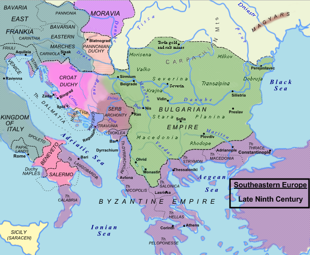
The map of Southeastern Europe in the late 9th century AD provides a detailed representation of the political landscape during a transformative period in European history. It illustrates the territories, borders, and key political entities that shaped the region at the time. The map captures the complexity of alliances, conflicts, and the evolving nature of governance in a time when empires were rising and falling, and cultures were blending.
Transitioning from the visual aspect, let’s delve into the political dynamics that characterized this era. The late 9th century was a period marked by the fragmentation of power and the emergence of various kingdoms and principalities. The map reveals a tapestry of diverse cultures, religions, and ethnicities that contributed to the rich historical narrative of Southeastern Europe.
Deep Dive into Political Entities
In the late 9th century, Southeastern Europe was a mosaic of different political entities, each with its own unique identity and governance structure. The Byzantine Empire, a formidable force during this time, controlled vast territories across the Balkans and beyond. Known for its sophisticated administration and cultural achievements, the Byzantine Empire was a center for commerce, education, and the arts. Interestingly, it was during this time that the empire faced significant challenges, including territorial disputes with emerging Slavic tribes and the rising influence of Bulgaria.
The First Bulgarian Empire was a notable entity on the map, having expanded rapidly and becoming a significant power in the region. Founded by Khan Asparuh, Bulgaria's influence grew due to its strategic location and military prowess. The Bulgarian state not only contended with the Byzantines but also played a crucial role in the spread of Christianity in the region, which would later shape the cultural landscape of Southeastern Europe.
Meanwhile, the map also highlights various smaller principalities and regions such as Dalmatia, Croatia, and Serbia, which were beginning to assert their identities and autonomy. These areas were often caught in the crossfire of the larger powers, leading to shifting allegiances and conflicts. For instance, the interactions between the Byzantine Empire and the emerging Slavic nations were complex, marked by both conflict and cooperation.
What’s fascinating is that this era laid the groundwork for the national identities that would emerge in later centuries. The establishment of trade routes, cultural exchanges, and even conflicts during this time would contribute to the formation of modern nation-states in the region.
Regional Analysis
When examining the map closely, we can see distinct political variations across regions. For example, the northern parts, such as modern-day Romania and Bulgaria, were influenced heavily by the Slavic migrations that transformed the demographic landscape. These migrations led to the establishment of various tribes and clans that would later unite under the banner of early Bulgarian kings.
Contrastingly, in the southern regions, particularly those under Byzantine control, one can observe a more centralized form of governance, characterized by the presence of large cities such as Thessalonica and Constantinople. These urban centers became hubs of cultural and economic activity, attracting people from diverse backgrounds and fostering a unique blend of traditions.
In the western parts of Southeastern Europe, areas like Croatia were navigating their paths toward autonomy while still being influenced by the larger powers surrounding them. The interaction between local rulers and the Byzantine Empire often led to a delicate balancing act, with local leaders vying for power while also maintaining favorable relations with their more powerful neighbors.
Significance and Impact
Understanding the political landscape of Southeastern Europe in the late 9th century is crucial for grasping the historical context that shaped modern Europe. This era was not just about borders and kingdoms; it was about the intertwining of cultures, religions, and identities that would influence the region for centuries to come.
The significance of this map extends beyond the past. Today, the legacies of these political entities are still felt in the contemporary geopolitical landscape. The historical conflicts and alliances formed during this time have had lasting impacts on national identities and regional stability. Furthermore, as we look to the future, the dynamics established in the late 9th century continue to resonate, influencing current discussions on nationalism, ethnic identity, and international relations in Southeastern Europe.
In conclusion, the map of Southeastern Europe in the late 9th century AD is not merely a snapshot of political boundaries; it is a window into a time of significant transformation that laid the foundation for the diverse and complex region we know today. By understanding this historical context, we can better appreciate the intricate tapestry of cultures and histories that define Southeastern Europe.
Visualization Details
- Published
- August 27, 2025
- Views
- 80
Comments
Loading comments...