North American Rail System Map

Alex Cartwright
Senior Cartographer & GIS Specialist
Alex Cartwright is a renowned cartographer and geographic information systems specialist with over 15 years of experience in spatial analysis and data...
Geographic Analysis
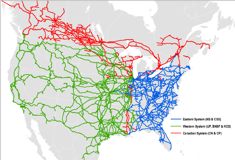
What This Map Shows
The North American Rail System Map provides a comprehensive visualization of the extensive rail network that spans the United States, Canada, and Mexico. This intricate web of tracks and lines highlights not only the major freight corridors but also passenger routes, connecting cities and regions across the continent. By examining this map, we can uncover the critical role railroads play in facilitating trade, transportation, and economic development in North America.
Deep Dive into the North American Rail System
Rail transport in North America is a vital component of the continent's infrastructure, enabling the movement of goods and people over long distances efficiently and cost-effectively. Interestingly, the rail system in the U.S. is the largest in the world, stretching over 138,000 miles, with Canada and Mexico adding substantial mileage to the network. This extensive reach allows for the transport of a diverse range of commodities, from agricultural products to manufactured goods, making railroads a backbone of the North American economy.
One of the most significant aspects of the North American rail system is its freight capacity. In 2020, North American railroads transported approximately 1.5 billion tons of cargo. Commodities such as coal, chemicals, and intermodal containers dominate freight traffic. Interestingly, intermodal transport, which involves moving cargo in standardized containers across different modes of transport, has seen significant growth in recent years due to globalization and the rise of e-commerce.
Passenger rail services, while not as dominant as freight, are also an important part of the rail landscape. Amtrak, the primary passenger rail service in the U.S., operates over 21,000 miles of track, serving over 30 million passengers annually. In Canada, Via Rail plays a similar role, connecting major cities and providing scenic routes through some of the country's most beautiful landscapes. What's fascinating is that despite the dominance of cars and air travel, there is a growing interest in enhancing passenger rail services to promote sustainable transportation options.
The rail system's impact extends beyond transportation; it influences urban development patterns and economic opportunities. Cities that are part of major rail corridors often experience increased investment and population growth. For instance, the Chicago rail hub is one of the busiest in the world, significantly contributing to the city’s economy. However, not all regions benefit equally; rural areas may face challenges in accessing rail services, leading to disparities in economic development.
Regional Analysis
When examining the North American Rail System Map, distinct regional characteristics emerge. The U.S. rail network is primarily divided into major freight corridors, such as the Union Pacific and BNSF Railway lines which dominate the western part of the country. In contrast, the eastern U.S. features a denser concentration of railroads, where historical routes established during the industrial revolution still play a crucial role today.
In Canada, the rail system is marked by its vastness, with the Canadian National Railway and Canadian Pacific Railway being the two major players. The geography of Canada—with its expansive wilderness and low population density—presents unique challenges for rail transport. Interestingly, the Quebec-Windsor Corridor is one of the most densely populated rail areas, linking major cities like Toronto and Montreal.
Mexico’s rail system, though smaller, has seen significant growth and modernization in recent years. The Mexican government has invested in upgrading rail infrastructure, particularly in freight transport, enhancing connections to U.S. markets. The Ferromex and Kansas City Southern de México lines are crucial for cross-border trade.
Significance and Impact
The North American Rail System is not just a network of tracks; it represents a lifeline for trade and mobility across the continent. Understanding this system is essential for grasping the economic dynamics that shape North America. As the demand for efficient transportation rises, the rail industry is poised for innovations, such as the adoption of greener technologies and the expansion of high-speed rail options.
Moreover, with growing concerns about climate change, the rail system offers a more sustainable alternative to road and air transport. Railroads are significantly more energy-efficient, producing lower greenhouse gas emissions per ton-mile than trucks or planes. As urban populations grow and the need for sustainable solutions intensifies, the rail system will likely play an increasingly important role in addressing transportation challenges.
In conclusion, the North American Rail System Map is not just a visual representation of tracks; it reflects the interconnectedness of economies, communities, and industries across the continent. By delving into the specifics of this network, we can appreciate its profound impact on our daily lives and future trajectories in transportation.
Visualization Details
- Published
- August 23, 2025
- Views
- 178
Comments
Loading comments...